• Welcome to TalkWeather!
    We see you lurking around TalkWeather! Take the extra step and join us today to view attachments, see less ads and maybe even join the discussion.
    CLICK TO JOIN TALKWEATHER

Severe WX April 3-6 Severe weather

Also, note for Georgia folks: this line may not be the last you get today. Models predict a reinvigoration of convection coinciding with LLJ-fueled instability flowing back into eastern Alabama and western Georgia. As such, additional storms are possible, especially in west-central Georgia and east-central Alabama. Helicity will also be strongest with those additional storms, so watch out for that.
View attachment 39352View attachment 39353
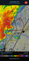
Seems like my model concurs with this. Stay vigilant in eastern central AL and west central GA
 
I'm somewhat dubious of the prospect of atmospheric recovery in western Georgia. While it's not impossible, I'm not sure if there will really be enough time for instability to move back into the area. Additionally, the northward extent of instability is far more meager than that modelled at this hour, although the pocket of instability in the Panhandle is actually a little stronger than forecast. We shall see.
1743966744377.png1743966755224.png
 
Didn't even notice it, but the Tornado Watch has been cancelled for northwest Georgia and some of north-central Georgia. FFC expects the remaining threat to exist south of I-20.
1743967298884.png
 
Yeah, the line looks to be basically out of steam at the moment and is just a rain/lightning threat. We'll see if that continues, but that's a good sign.
RAP still predicts some atmospheric recovery behind this MCS, but I just find it hard to believe. However, the system as a whole is moving slowly, and HRRR depicts re-intensification of convection come Monday morning in central Georgia.
 
Back
Top