Navigation
Install the app
How to install the app on iOS
Follow along with the video below to see how to install our site as a web app on your home screen.
Note: This feature may not be available in some browsers.
More options
-
Welcome to TalkWeather! We see you lurking around TalkWeather! Take the extra step and join us today to view attachments, see less ads and maybe even join the discussion. CLICK TO JOIN TALKWEATHER
You are using an out of date browser. It may not display this or other websites correctly.
You should upgrade or use an alternative browser.
You should upgrade or use an alternative browser.
Severe WX April 3-6 Severe weather
- Thread starter UncleJuJu98
- Start date
snostorm21
Member
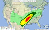
04z HRRR continues to paint a bad picture over East Texas and AR tmrw. Extreme parameters in place and if storms can remain discrete, could be a very dangerous day.
Kds86z
Member
Welcome btw! @snostorm21 . Appreciate your input this week.04z HRRR continues to paint a bad picture over East Texas and AR tmrw. Extreme parameters in place and if storms can remain discrete, could be a very dangerous day.
US_Highway15
Member
Kds86z
Member
AJS
Member
- Thread starter
- #287
Latest HRRR runs are not as impressive for Arkansas today as they were.
Uh, are you sure about that? The 10z had multiple long tracked supercells in the MDT risk.Latest HRRR runs are not as impressive for Arkansas today as they were.
brianc33710
Member
Apparently the straight line wind threat is comparatively low. I see nothing higher than 15% & nothing hatched despite the SPC using "Damaging," the 80 mph criteria at local NWS offices. This sets off STWarns emergency devices & sirens in polygons. Will they upgrade that later to match the other threats? Should they? This took place in a later update Wed.
- Thread starter
- #290
I see what your talking about, I was mainly referencing the 12z and 18z yesterday and what they showed. 10z and some of the other runs still looks dangerous though. (Looking closer at the 10z though it has multiple supercells close to the line which wouldn't be good)Uh, are you sure about that? The 10z had multiple long tracked supercells in the MDT risk.


- Thread starter
- #291
AJS
Member
Brad Arnold isn’t one to overhype or hyperbolize either. Based on the HRRR and parameters in place, it sure seems like today could be another ugly day.
- Thread starter
- #293
I'll be curious to see where him and copic start there chaseBrad Arnold isn’t one to overhype or hyperbolize either. Based on the HRRR and parameters in place, it sure seems like today could be another ugly day.
Keldeo
Member
Keldeo
Member
Also not severe but LOL
Also not severe but LOL
"If you don't like the weather, wait five minutes."
It really is wild how parameters have to be in almost perfect balance to get an outbreak. Moisture? Got to have it, but not that deep. Daytime heating? Helps a lot, but it can’t get too hot (see Wednesday day). Forcing? Essential, but not too much or you’ll have too many storms go up. Cap/EML? Essential and helps, but if it’s too stout and there’s a mistimed trough/shortwave ejection, you may not get a drop of rain.02Z HRRR forecast sounding for somewhere in the vicinity of Little Rock at 20Z tomorrow, with active supercells to the west and initiation of others underway at FH018 (end of the run).
That's...some hodograph.
Of note is also the moisture depth. That's almost deeper than you want it to be ideal for tornado production, so something to keep an eye on.
View attachment 38962
kcyalater
Member
did arkansas steal nature’s puppy or something? this svr szn seems a bit personal.


