
Navigation
Install the app
How to install the app on iOS
Follow along with the video below to see how to install our site as a web app on your home screen.
Note: This feature may not be available in some browsers.
More options
-
Welcome to TalkWeather! We see you lurking around TalkWeather! Take the extra step and join us today to view attachments, see less ads and maybe even join the discussion. CLICK TO JOIN TALKWEATHER
You are using an out of date browser. It may not display this or other websites correctly.
You should upgrade or use an alternative browser.
You should upgrade or use an alternative browser.
Severe WX April 11-14th, 2022 Severe Weather Threat
- Thread starter KevinH
- Start date
- Moderator
- #142
The GFS most notably since yesterday’s 18z run has trended toward the more severe solution for Wednesday. Finally, falling in line with the other models.
Last edited:

Brice Wood
Member
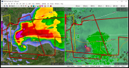
Structure reminds me of the beginning stages of the Moore 2013 tornadoDefinitely trying to do something right now
View attachment 13363
CheeselandSkies
Member
TH2002
Member
- Messages
- 4,974
- Reaction score
- 11,116
- Location
- California, United States
- Special Affiliations
- SKYWARN® Volunteer
Only thing missing now is the CC drop

CheeselandSkies
Member
Now if only there could be 2 or 3 of these down the dryline tomorrow for the Plains chasers...
cincywx
Member
insane radar presentation
TornadoFan
Member
Now if only there could be 2 or 3 of these down the dryline tomorrow for the Plains chasers...

Multi-vortex tornado has been down based on multiple chaser streams.
OHWX97
Member
Should note that this is not supposed to peak until around 00z or even after per most high res guidance. Think Conway might have some issues later if this cell keeps going into Central AR.
Agreed. All we've really done so far is establish surface-based perturbations for when the low-level jet ramps up after sunset.Should note that this is not supposed to peak until around 00z or even after per most high res guidance. Think Conway might have some issues later if this cell keeps going into Central AR.
OHWX97
Member
Likely a new tornado developing near Ratcliff and Caulksville, AR.
TH2002
Member
- Messages
- 4,974
- Reaction score
- 11,116
- Location
- California, United States
- Special Affiliations
- SKYWARN® Volunteer
Is it possible more cells could fire in the S to NE OK vicinity as the LLJ increases in strength?Agreed. All we've really done so far is establish surface-based perturbations for when the low-level jet ramps up after sunset.
MattPetrulli
Member
Imo the thing preventing it from taking off is meager low level shear, as seen from Ft Smith VWP and as mentioned in previous commentsThe cell just to the west near Lavaca is interacting with the main one, which could be holding it back from taking off, at least for the moment.

Should improve as evening goes on, however. Especially watch those cells in SE Oklahoma that are currently severe warned.
Edit: Cell behind it as said could also factor in to this.
TH2002
Member
- Messages
- 4,974
- Reaction score
- 11,116
- Location
- California, United States
- Special Affiliations
- SKYWARN® Volunteer
Looks like a CC drop at first glance, but could just be radar noise given the lackluster velocity presentation?

TornadoFan
Member
Wonder if that western storm is gonna become the main show.