MattPetrulli
Member
HRRR has been pretty consistent with developing a single monster supercell in the Ft Dodge, IA area in the evening, along with the line of storms after that showing some discrete characteristics.

Follow along with the video below to see how to install our site as a web app on your home screen.
Note: This feature may not be available in some browsers.
For fun this is just in front of that cell developingHRRR has been pretty consistent with developing a single monster supercell in the Ft Dodge, IA area in the evening, along with the line of storms after that showing some discrete characteristics.
View attachment 13382


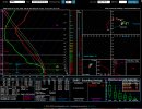
Agreed, hopefully we can avoid towns, but I really personally think we have violent tornado potential if HRRR plays out correctly.Really concerned personally about Iowa this evening. Absolute masses of low-level helicity. Given consistent modelling of discrete supercells by HRRR, I am worried as any discrete storm must have very significant tornado potential. Does anyone know when the last time we had discrete storms in this kind of shear profile was? Wouldn't be surprised to see some very intense tornadoes possibly, but hopefully I am wrong. View attachment 13385
I don’t believe you are.. we will seeReally concerned personally about Iowa this evening. Absolute masses of low-level helicity. Given consistent modelling of discrete supercells by HRRR, I am worried as any discrete storm must have very significant tornado potential. Does anyone know when the last time we had discrete storms in this kind of shear profile was? Wouldn't be surprised to see some very intense tornadoes possibly, but hopefully I am wrong. View attachment 13385


HRRR looks horrible for that area.Really concerned personally about Iowa this evening. Absolute masses of low-level helicity. Given consistent modelling of discrete supercells by HRRR, I am worried as any discrete storm must have very significant tornado potential. Does anyone know when the last time we had discrete storms in this kind of shear profile was? Wouldn't be surprised to see some very intense tornadoes possibly, but hopefully I am wrong. View attachment 13385

50/50 split of CAMS for initiation. I think that initiation seems quite likely. Could be a long evening for some... potential to be one of the higher end events of the year i think.HRRR looks horrible for that area.
I’m afraid you’re right. Today and tomorrow may both be long ones, unfortunately.50/50 split of CAMS for initiation. I think that initiation seems quite likely. Could be a long evening for some... potential to be one of the higher end events of the year i think.
Those stations have considerably higher DPs than the surrounding ones. Could they be errors? (Not to discount the environment that is otherwise setting itself up there)Dewpoints are already into the 70's in SW Iowa.
Look like errors to me - some nearby stations not even into the 60s yet.Those stations have considerably higher DPs than the surrounding ones. Could they be errors?
The two soundings you linked have some of the craziest hodos I’ve seen. Man. I am hoping things don’t pan out as modeled…I mean this is a joke... some of the most favourable wind profiles I have ever seen in the path of a modelled discrete supercell. I am seriously worried.
View attachment 13388