• Welcome to TalkWeather!
    We see you lurking around TalkWeather! Take the extra step and join us today to view attachments, see less ads and maybe even join the discussion.
    CLICK TO JOIN TALKWEATHER

2025 Global Tropical Cyclone Season Discussion

Tropical Depression 26W was given the international name of Bualoi earlier today and it also received the Philippine name Opong (which is the replacement name of Odette in the Philippines after Super Typhoon Rai carried the name Odette in 2021 and became a destructive typhoon, warranting its retirement in the spring of 2022)
 
Bualoi is steadily improving in organization as it approaches the Philippines. Neoguri and Ragasa are on their way out and Narda in the Eastern Pacific is mostly holding steady right now with brief expected weakening back to a Category 1 from its current Category 2 due to wind shear. It will likely reintensify into a Category 2 before turning poleward and crossing into cold waters and dissapting.
 
From S2K:
IMG_8110.jpeg
We have Tropical Storm Humberto now.
 
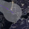
It’s not that often that an Atlantic tropical cyclone has a cone of uncertainty including some form of land from Africa, especially Morocco.
Gabrielle has a cone of uncertainty as such right now:
IMG_8114.jpeg
 
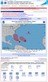
The famous banner from the NHC has appeared:
IMG_8119.jpeg
 
Almost all of the hurricane-regional models like HAFS-A and B are trying to make both Humberto and Invest 94L into hurricanes and the most recent run time has gone on to having like 95% of all of the hurricane models making 94L a MH.

On a related note, the NHC now expects Humberto to become a 100-kt (115 mph) major hurricane near the end of the five day forecast period.
 
Well, well… the 06Z intensity of 55 kts (65 mph) on Humberto was overridden and changed to 65 kts (75 mph), so say hello to another Hurricane Humberto and the sixth consecutive iteration of Humberto to become a hurricane in a row since its Category 2 debut in 1995.
 
Hurricane Humberto is trying to rotate duel hot towers around where its eye will appear in the future.

To note, no season in the 21st century so far has had its first three hurricanes all become major hurricanes, and the last season to have all of its first 3 hurricanes all become major hurricanes was this season below:

1935 was the year of the strongest landfalling hurricane ever recorded on U.S. soil, the 1935 Labor Day Hurricane.
 
Last edited:
Hurricane Humberto is trying to rotate duel hot towers around where its eye will appear in the future.

To note, no season in the 21st century so far has had its first three hurricanes all become major hurricanes, and the last season to have all of its first 3 hurricanes all become major hurricanes was this season below:

1935 was the year of the strongest landfalling hurricane ever recorded on U.S. soil, the 1935 Labor Day Hurricane.

Well Humberto became a major hurricane, which means that 2025 is 3 for 3 for the first time in 90 years.
 
Bualoi in the Western Pacific has become the 11th typhoon of the season with a current intensity of 65 kts (75 mph). The JTWC expects Bualoi to intensify to 85 kts (100 mph) over the warm waters of the South China Sea and into the Gulf of Tonkin before moving inland and dissipating.
 
All Category 5s or Category 5-equivalent cyclones I’ve tracked
————————————————————
Rai 2021 (WPAC)

Ian 2022 (NATL)

Nanmadol 2022 (WPAC) (tracked the storm, but missed the Cat 5 peak)

Otis 2023 (EPAC) (tracked the storm, but missed the Cat 5 peak)

Lee 2023 (NATL)

Jova 2023 (EPAC)

Mawar 2023 (WPAC)

Bolaven 2023 (WPAC)

Mocha (NIO, 2023)

Ilsa 2023 (AR)

Freddy 2023 (AR to SWIO)

Beryl 2024 (NATL)

Milton (NATL, 2024)

Kristy 2024 (EPAC)

Man-yi 2024 (WPAC)

Yagi 2024 (WPAC)

Errol 2025 (AR)

Erin 2025 (NATL)

Ragasa 2025 (WPAC)
If the year is in parentheses, then it was used only once.
 
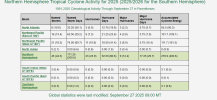
The Atlantic currently is below normal ACE by 25 points. I figure after Humberto and Imelda, the Atlantic will surge above normal. The Eastern Pacific is 7 points off normal ACE. But the most remarkable thing is that, even though the Western Pacific has had quite the uptick in activity recently, their normal ACE is still off by 79.6 points.
 

Attachments

  • Screenshot 2025-09-27 155757.png
    Screenshot 2025-09-27 155757.png
    75.2 KB · Views: 0
With Humberto now a cat 5, this is the first time in 92 years with multiple Category 5 hurricanes in back to back years. The previous time was during in the Great Depression in 1932/1933.
 
Also, this marks only the 3rd time since 1950 that 3 or 4 consecutive Atlantic hurricane seasons have had at least one or more category 5 hurricanes.

2003 thru 2005
2016 thru 2019
2022 thru 2025
 
 
The Atlantic currently is below normal ACE by 25 points. I figure after Humberto and Imelda, the Atlantic will surge above normal. The Eastern Pacific is 7 points off normal ACE. But the most remarkable thing is that, even though the Western Pacific has had quite the uptick in activity recently, their normal ACE is still off by 79.6 points.
The Atlantic is making a very impressive comeback
 
The Atlantic is making a very impressive comeback
Yeah. It's getting back at the folks who said hurricane season was over with.
 
Yeah. It's getting back at the folks who said hurricane season was over with.
I told @Kds86z the same thing I’m about to tell you about October.

I won’t be surprised if October was a decently active to very active month after seeing what the end of September had in store.
 
Back
Top