- Thread starter
- #1,061
Navigation
Install the app
How to install the app on iOS
Follow along with the video below to see how to install our site as a web app on your home screen.
Note: This feature may not be available in some browsers.
More options
-
Welcome to TalkWeather! We see you lurking around TalkWeather! Take the extra step and join us today to view attachments, see less ads and maybe even join the discussion. CLICK TO JOIN TALKWEATHER
You are using an out of date browser. It may not display this or other websites correctly.
You should upgrade or use an alternative browser.
You should upgrade or use an alternative browser.
2025 Global Tropical Cyclone Season Discussion
- Thread starter Atlantic
- Start date
- Thread starter
- #1,062
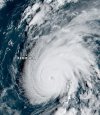
And this is definitely a change from about 4 days ago when Gabrielle was a naked swirl practically.Gabrielle may be near MH status right now. Current intensity is 80 kts (90 mph) and the NHC expects it to peak at 105 kts (120 mph).
View attachment 46599
- Thread starter
- #1,063
- Admin
- #1,064
- Messages
- 2,307
- Reaction score
- 1,921
- Location
- Meridianville, Al
- Special Affiliations
- SKYWARN® Volunteer
Yet another rapidly intensifying storm.
As for Ragasa, its headed for China, as is iCyclone. I think that will be his first chase in China.
As for Ragasa, its headed for China, as is iCyclone. I think that will be his first chase in China.
- Thread starter
- #1,065
Kds86z
Member
- Thread starter
- #1,067
- Thread starter
- #1,068
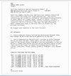
Found this on Storm2K and because it’s so accurate I thought I should share it here.For context of this slow hurricane season
View attachment 46601
- Thread starter
- #1,069
I predicted 16/9/5 in my final preseason prediction in May.
Now here is my updated September prediction:
I expect the season will end on 15/7/3 pending a moderately active October-November timeframe.
My final prediction will be up on October 15.
————————————————————
My new range is:
13-17 NS
5-8 HU
2-4 MH
(^Includes storms that have occurred already)
————————————————————
Background on my predictions:
————————————————————
I watch the trends in models and in realtime as they occur. I then formulate analogs based off of these trends and data. I put out predictions starting in late-November for the following year’s hurricane season before the previous one has ended. I have do this since 2022 privately, but I put it out online for the first time in November 2024. I release my predictions once a month (November, December, January, February, March, April and May) before the season starts. I release my last prediction of the preseason in May and then lay it to rest for the summer.
I then release two final late season predictions in September and October as corrections to my preseason numbers based off of how the season has progressed up to August. The final two predictions are meant to hew as closely as possible to whatever the season’s final numbers are.
- Thread starter
- #1,070
Kds86z
Member
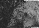
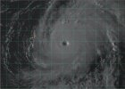
Gabrielle goes…Four. Days. Difference.
September 18
View attachment 46607
September 22 (today)
View attachment 46608

Kds86z
Member
- Thread starter
- #1,073
Invest 92W in the Western Pacific has been upgraded to a High Chance with a TCFA having been issued earlier this morning by the JTWC. 92W is likely anytime now to receive the Philippine name Opong and it is forecast by the models to go through the central Philippines before moving into the South China Sea.

WTPN21 PGTW 230200
MSGID/GENADMIN/JOINT TYPHOON WRNCEN PEARL HARBOR HI//
SUBJ/TROPICAL CYCLONE FORMATION ALERT (INVEST 92W)//
RMKS/
1. FORMATION OF A SIGNIFICANT TROPICAL CYCLONE IS POSSIBLE WITHIN
100 NM EITHER SIDE OF A LINE FROM 10.2N 138.4E TO 10.5N 134.3E
WITHIN THE NEXT 12 TO 24 HOURS. AVAILABLE DATA DOES NOT JUSTIFY
ISSUANCE OF NUMBERED TROPICAL CYCLONE WARNINGS AT THIS TIME.
WINDS IN THE AREA ARE ESTIMATED TO BE 18 TO 22 KNOTS. METSAT
IMAGERY AT 230000Z INDICATES THAT A CIRCULATION CENTER IS LOCATED
NEAR 10.2N 138.2E. THE SYSTEM IS MOVING WESTWARD AT 03 KNOTS.
2. REMARKS: THE AREA OF CONVECTION (INVEST 92W) PREVIOUSLY LOCATED NEAR
11.1N 138.2E IS NOW LOCATED 10.2N 138.2E, APPROXIMATELY 40.3 NM NORTH OF
YAP. ANIMATED MULTISPECTRAL SATELLITE IMAGERY (MSI) SHOWS PERSISTENT
DEEP CONVECTION CONSOLIDATING OVER A DEVELOPING LOW LEVEL CIRCULATION
CENTER. A 230035Z ASCAT VERIFIES A CLOSED CIRCULATION HAS DEVELOPED,
WITH 15-20 KNOT WINDS WRAPPING FROM THE NORTH OF THE CIRCULATION CENTER.
THE ENVIRONMENT IS FAVORABLE FOR DEVELOPMENT WITH WARM SEA SURFACE
TEMPERATURES (29-30 C) AND MODERATE VERTICAL WIND SHEAR (15-20 KTS) AND
GOOD EQUATORWARD OUTFLOW ALOFT. GLOBAL DETERMINISTIC MODELS ARE IN GOOD
AGREEMENT THAT 92W WILL INTENSIFY OVER THE NEXT 24 HOURS. GLOBAL
ENSEMBLE MODELS ARE IN AGREEMENT AS WELL THAT 92W WILL CONTINUE TO MOVE
WESTWARD AND INTENSIFY OVER THE NEXT 24 HOURS. MAXIMUM SUSTAINED SURFACE
WINDS ARE ESTIMATED AT 18 TO 22 KNOTS. MINIMUM SEA LEVEL PRESSURE IS
ESTIMATED TO BE NEAR 1007 MB. THE POTENTIAL FOR THE DEVELOPMENT OF A
SIGNIFICANT TROPICAL CYCLONE WITHIN THE NEXT 24 HOURS IS HIGH.
3. THIS ALERT WILL BE REISSUED, UPGRADED TO WARNING OR CANCELLED BY
240200Z.
//
NNNN
Kds86z
Member
- Thread starter
- #1,075
Storm formation by month:
Color legend:
NATL
EPAC/CPAC
WPAC
NIO
SPAC
AR
SWIO
SATL
MED
————————————————————
January 2025-
Intense Tropical Cyclone Dikeledi - 115 mph
Tropical Cyclone Pita - 50 mph
Tropical Cyclone Nine - 35 mph
Severe Tropical Cyclone Sean - 130 mph
Moderate Tropical Storm Faida - 50 mph
Moderate Tropical Storm Elvis - 50 mph
February 2025-
Intense Tropical Cyclone Vince - 155 mph
Severe Tropical Cyclone Taliah - 105 mph
Tropical Cyclone Fifteen - 50 mph
Tropical Cyclone Sixteen - 45 mph
Severe Tropical Cyclone Zelia - 150 mph
Severe Tropical Cyclone Alfred - 130 mph
Tropical Cyclone Rae - 105 mph
Severe Tropical Cyclone Bianca - 115 mph
Tropical Cyclone Seru - 75 mph
Intense Tropical Cyclone Garance - 120 mph
Tropical Cyclone Honde - 80 mph
March 2025-
Severe Tropical Storm Ivone - 65 mph
Tropical Cyclone Jude - 90 mph
Tropical Cyclone Twenty-Six - 50 mph
Intense Tropical Cyclone Courtney - 150 mph
Tropical Cyclone Dianne - 50 mph
April 2025-
Severe Tropical Cyclone Errol - 160 mph
Tropical Cyclone Tam - 60 mph
Tropical Cyclone Thirty-One - 40 mph
May 2025-
Tropical Cyclone Thirty-Two - 40 mph
Tropical Storm Alvin - 65 mph
June 2025-
Hurricane Barbara - 75 mph
Tropical Storm Cosme - 70 mph
Typhoon Wutip - 75 mph
Tropical Storm Dalila - 65 mph
Hurricane Erick - 140 mph
Tropical Storm Sepat - 45 mph
Tropical Storm Andrea - 40 mph
Tropical Depression 03W - 35 mph
Tropical Storm Barry - 45 mph
Hurricane Flossie - 120 mph
July 2025-
Tropical Storm Mun - 70 mph
Typhoon Danas - 115 mph
Tropical Storm Chantal - 60 mph
Tropical Storm Nari - 60 mph
Subtropical Depression 07W - 35 mph
Tropical Storm 08W - 45 mph
Typhoon Wipha - 75 mph
Moderate Tropical Storm One - 40 mph
Typhoon Co-May - 80 mph
Tropical Storm Francisco - 45 mph
Typhoon Krosa - 90 mph
Hurricane Iona - 125 mph
Tropical Storm Keli - 40 mph
Hurricane Gil - 75 mph
- Thread starter
- #1,076
August 2025-Storm formation by month:
Color legend:
NATL
EPAC/CPAC
WPAC
NIO
SPAC
AR
SWIO
SATL
MED
————————————————————
January 2025-
Intense Tropical Cyclone Dikeledi - 115 mph
Tropical Cyclone Pita - 50 mph
Tropical Cyclone Nine - 35 mph
Severe Tropical Cyclone Sean - 130 mph
Moderate Tropical Storm Faida - 50 mph
Moderate Tropical Storm Elvis - 50 mph
February 2025-
Intense Tropical Cyclone Vince - 155 mph
Severe Tropical Cyclone Taliah - 105 mph
Tropical Cyclone Fifteen - 50 mph
Tropical Cyclone Sixteen - 45 mph
Severe Tropical Cyclone Zelia - 150 mph
Severe Tropical Cyclone Alfred - 130 mph
Tropical Cyclone Rae - 105 mph
Severe Tropical Cyclone Bianca - 115 mph
Tropical Cyclone Seru - 75 mph
Intense Tropical Cyclone Garance - 120 mph
Tropical Cyclone Honde - 80 mph
March 2025-
Severe Tropical Storm Ivone - 65 mph
Tropical Cyclone Jude - 90 mph
Tropical Cyclone Twenty-Six - 50 mph
Intense Tropical Cyclone Courtney - 150 mph
Tropical Cyclone Dianne - 50 mph
April 2025-
Severe Tropical Cyclone Errol - 160 mph
Tropical Cyclone Tam - 60 mph
Tropical Cyclone Thirty-One - 40 mph
May 2025-
Tropical Cyclone Thirty-Two - 40 mph
Tropical Storm Alvin - 65 mph
June 2025-
Hurricane Barbara - 75 mph
Tropical Storm Cosme - 70 mph
Typhoon Wutip - 75 mph
Tropical Storm Dalila - 65 mph
Hurricane Erick - 140 mph
Tropical Storm Sepat - 45 mph
Tropical Storm Andrea - 40 mph
Tropical Depression 03W - 35 mph
Tropical Storm Barry - 45 mph
Hurricane Flossie - 120 mph
July 2025-
Tropical Storm Mun - 70 mph
Typhoon Danas - 115 mph
Tropical Storm Chantal - 60 mph
Tropical Storm Nari - 60 mph
Subtropical Depression 07W - 35 mph
Tropical Storm 08W - 45 mph
Typhoon Wipha - 75 mph
Moderate Tropical Storm One - 40 mph
Typhoon Co-May - 80 mph
Tropical Storm Francisco - 45 mph
Typhoon Krosa - 90 mph
Hurricane Iona - 125 mph
Tropical Storm Keli - 40 mph
Hurricane Gil - 75 mph
Tropical Storm Bailu - 40 mph
Tropical Storm Dexter - 50 mph
Tropical Depression 14W - 30 mph
Hurricane Henriette - 85 mph
Tropical Depression 15W - 30 mph
Tropical Storm Ivo - 65 mph
Moderate Tropical Storm Awo - 40 mph
Typhoon Podul - 110 mph
Hurricane Erin - 160 mph
Tropical Depression 17W - 35 mph
Tropical Storm Lingling - 50 mph
Typhoon Kajiki - 110 mph
Tropical Storm Fernand - 60 mph
Tropical Storm Juliette - 70 mph
Tropical Storm Nongfa - 40 mph
Hurricane Kiko - 145 mph
- Thread starter
- #1,077
September 2025 -Storm formation by month:
Color legend:
NATL
EPAC/CPAC
WPAC
NIO
SPAC
AR
SWIO
SATL
MED
————————————————————
January 2025-
Intense Tropical Cyclone Dikeledi - 115 mph
Tropical Cyclone Pita - 50 mph
Tropical Cyclone Nine - 35 mph
Severe Tropical Cyclone Sean - 130 mph
Moderate Tropical Storm Faida - 50 mph
Moderate Tropical Storm Elvis - 50 mph
February 2025-
Intense Tropical Cyclone Vince - 155 mph
Severe Tropical Cyclone Taliah - 105 mph
Tropical Cyclone Fifteen - 50 mph
Tropical Cyclone Sixteen - 45 mph
Severe Tropical Cyclone Zelia - 150 mph
Severe Tropical Cyclone Alfred - 130 mph
Tropical Cyclone Rae - 105 mph
Severe Tropical Cyclone Bianca - 115 mph
Tropical Cyclone Seru - 75 mph
Intense Tropical Cyclone Garance - 120 mph
Tropical Cyclone Honde - 80 mph
March 2025-
Severe Tropical Storm Ivone - 65 mph
Tropical Cyclone Jude - 90 mph
Tropical Cyclone Twenty-Six - 50 mph
Intense Tropical Cyclone Courtney - 150 mph
Tropical Cyclone Dianne - 50 mph
April 2025-
Severe Tropical Cyclone Errol - 160 mph
Tropical Cyclone Tam - 60 mph
Tropical Cyclone Thirty-One - 40 mph
May 2025-
Tropical Cyclone Thirty-Two - 40 mph
Tropical Storm Alvin - 65 mph
June 2025-
Hurricane Barbara - 75 mph
Tropical Storm Cosme - 70 mph
Typhoon Wutip - 75 mph
Tropical Storm Dalila - 65 mph
Hurricane Erick - 140 mph
Tropical Storm Sepat - 45 mph
Tropical Storm Andrea - 40 mph
Tropical Depression 03W - 35 mph
Tropical Storm Barry - 45 mph
Hurricane Flossie - 120 mph
July 2025-
Tropical Storm Mun - 70 mph
Typhoon Danas - 115 mph
Tropical Storm Chantal - 60 mph
Tropical Storm Nari - 60 mph
Subtropical Depression 07W - 35 mph
Tropical Storm 08W - 45 mph
Typhoon Wipha - 75 mph
Moderate Tropical Storm One - 40 mph
Typhoon Co-May - 80 mph
Tropical Storm Francisco - 45 mph
Typhoon Krosa - 90 mph
Hurricane Iona - 125 mph
Tropical Storm Keli - 40 mph
Hurricane Gil - 75 mph
Hurricane Lorena - 75 mph
Tropical Storm Peipah - 60 mph
Typhoon Tapah - 75 mph
Moderate Tropical Storm Blossom - 45 mph
Tropical Storm Mario - 65 mph
Tropical Storm Mitag - 50 mph
Super Typhoon Ragasa - 165 mph
Typhoon Neoguri - 145 mph
Hurricane Narda -
Typhoon Bualoi -
- Thread starter
- #1,078
Tropical Depression/Subtropical Depression
Tropical Storm/Subtropical Storm
Category 1
Category 2
Category 3
Category 4
Category 5
————————————————————
January 2025-
Dikeledi - 115 mph
Pita - 50 mph
09S - 35 mph
Sean - 130 mph
Faida - 50 mph
Elvis - 50 mph
February 2025-
Vince - 155 mph
Taliah - 105 mph
15P - 50 mph
16P - 45 mph
Zelia - 150 mph
Alfred - 130 mph
Rae - 105 mph
Bianca - 115 mph
Seru - 75 mph
Garance - 120 mph
Honde - 80 mph
March 2025-
Ivone - 65 mph
Jude - 90 mph
26S - 50 mph
Courtney - 150 mph
Dianne - 50 mph
April 2025-
Errol - 160 mph
Tam - 60 mph
31S - 40 mph
May 2025-
32P - 40 mph
Alvin - 65 mph
June 2025-
Barbara - 75 mph
Cosme - 70 mph
Wutip - 75 mph
Dalila - 65 mph
Erick - 140 mph
Sepat - 45 mph
Andrea - 40 mph
03W - 35 mph
Barry - 45 mph
Flossie - 120 mph
July 2025-
Mun - 70 mph
Danas - 115 mph
Chantal - 60 mph
Nari - 60 mph
07W - 35 mph
08W - 45 mph
Wipha - 75 mph
01S - 40 mph
Co-May - 80 mph
Francisco - 45 mph
Krosa - 90 mph
Iona - 125 mph
Keli - 40 mph
Gil - 75 mph
- Thread starter
- #1,079
August 2025-
Bailu - 40 mph
Dexter - 50 mph
14W - 30 mph
Henriette - 85 mph
15W - 30 mph
Ivo - 65 mph
Awo - 40 mph
Podul - 110 mph
Erin - 160 mph
17W - 35 mph
Lingling - 50 mph
Kajiki - 110 mph
Fernand - 60 mph
Juliette - 70 mph
Nongfa - 40 mph
Kiko - 145 mph
Bailu - 40 mph
Dexter - 50 mph
14W - 30 mph
Henriette - 85 mph
15W - 30 mph
Ivo - 65 mph
Awo - 40 mph
Podul - 110 mph
Erin - 160 mph
17W - 35 mph
Lingling - 50 mph
Kajiki - 110 mph
Fernand - 60 mph
Juliette - 70 mph
Nongfa - 40 mph
Kiko - 145 mph
- Thread starter
- #1,080

