
Yeah. I'm not well versed in the Western Pacific tropical mechanisms. However, I really need to do a spreadsheet like I did with the Atlantic systems with the MJO correlation. I just have a lot of projects on my plate, but I'll get to that eventually.2024 was odd, but 2023 was odder.
2024 I could understand, with a strong El Niño degrading into a neutral phase.
2023 is an anomaly to me. A strong El Niño, but the season was the second least active on record.
Heck, the ATL was the opposite; producing a near-hurricane in January and the turning around and producing 19 additional storms by the end of October.
102 days now, what has been happening to the WPAC these past five years?
Navigation
Install the app
How to install the app on iOS
Follow along with the video below to see how to install our site as a web app on your home screen.
Note: This feature may not be available in some browsers.
More options
-
Welcome to TalkWeather! We see you lurking around TalkWeather! Take the extra step and join us today to view attachments, see less ads and maybe even join the discussion. CLICK TO JOIN TALKWEATHER
You are using an out of date browser. It may not display this or other websites correctly.
You should upgrade or use an alternative browser.
You should upgrade or use an alternative browser.
2025 Global Tropical Cyclone Season Discussion
- Thread starter Atlantic
- Start date
- Thread starter
- #282

- Thread starter
- #283
The only things I could think of that killed activity in 2023 was all that warmth near Japan and the -PDO which apparently appears to still be ongoing.Yeah. I'm not well versed in the Western Pacific tropical mechanisms. However, I really need to do a spreadsheet like I did with the Atlantic systems with the MJO correlation. I just have a lot of projects on my plate, but I'll get to that eventually.
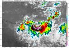
It is. And to add to your analysis above, it also has more to do with the difference in pressure patterns too. I just don't know how to explain that part.I’ve been seeing this trending on the GFS near the end of the past several consecutive runs; @JPWX do you know if this is in Port Moresby’s AoR of the Australian Region?
View attachment 39728
IdaliaHelene
Member
- Messages
- 475
- Reaction score
- 610
- Location
- Keaton Beach
- Special Affiliations
- SKYWARN® Volunteer
- ARRL Member
JFL AT ERROL
- Thread starter
- #286
- Thread starter
- #287
Invest 97P (Tropical Low 30U) has a high chance of development in the next 24-48 hours according to the JTWC. As with all high chance invests the JTWC has issued a TCFA on it:

WTPS21 PGTW 172130
MSGID/GENADMIN/JOINT TYPHOON WRNCEN PEARL HARBOR HI//
SUBJ/TROPICAL CYCLONE FORMATION ALERT (INVEST 97P)//
RMKS/
1. FORMATION OF A SIGNIFICANT TROPICAL CYCLONE IS POSSIBLE WITHIN
160 NM EITHER SIDE OF A LINE FROM 9.8S 138.6E TO 13.1S 140.2E
WITHIN THE NEXT 12 TO 24 HOURS. AVAILABLE DATA DOES NOT JUSTIFY
ISSUANCE OF NUMBERED TROPICAL CYCLONE WARNINGS AT THIS TIME.
WINDS IN THE AREA ARE ESTIMATED TO BE 28 TO 33 KNOTS. METSAT
IMAGERY AT 171800Z INDICATES THAT A CIRCULATION CENTER IS LOCATED
NEAR 10.0S 138.6E. THE SYSTEM IS MOVING SOUTHEASTWARD AT 08
KNOTS.
2. REMARKS: THE AREA OF CONVECTION (INVEST 97P) PREVIOUSLY LOCATED
NEAR 9.7N 137.9E IS NOW LOCATED NEAR 10.0N 138.6E, APPROXIMATELY
172 NM NORTHEAST OF GOVE AIRPORT, AUSTRALIA. ANIMATED MULTISPECTRAL
SATELLITE IMAGERY DEPICTS A DEEP AND PERSISTENT AREA OF CONVECTION.
UPPER-LEVEL ANALYSIS REVEALS A FAVORABLE ENVIRONMENT WITH WARM SEA
SURFACE TEMPERATURES (30C), LOW VERTICAL WIND SHEAR (10-15KT), DEEP
TROPICAL MOISTURE, AND GOOD POLEWARD OUTFLOW. GLOBAL MODELS ARE IN
GOOD AGREEMENT WITH 97P TRACKING SOUTHEASTWARD WITH DEVELOPMENT AND
STEADY INTENSIFICATION IN THE NEXT 24 HOURS. MAXIMUM SUSTAINED SURFACE
WINDS ARE ESTIMATED AT 28 TO 33 KNOTS. MINIMUM SEA LEVEL PRESSURE IS
ESTIMATED TO BE NEAR 998 MB. THE POTENTIAL FOR THE DEVELOPMENT OF A
SIGNIFICANT TROPICAL CYCLONE WITHIN THE NEXT 24 HOURS IS HIGH.
3. THIS ALERT WILL BE REISSUED, UPGRADED TO WARNING OR CANCELLED BY
182130Z.
//
NNNN
—-—————————————————
The BoM does not expect this system to become a TC, as evident by their forecast;

Invest 99S is now a Zone of Disturbed Weather without a number ID according to Meteo-France. The JTWC is still maintaining this disturbance as a low chance invest.
Meteo-France is also noting the possibility of subtropical development a little ways south of Madagascar too. Note: top half is the JTWC’s 99S.


WTPS21 PGTW 172130
MSGID/GENADMIN/JOINT TYPHOON WRNCEN PEARL HARBOR HI//
SUBJ/TROPICAL CYCLONE FORMATION ALERT (INVEST 97P)//
RMKS/
1. FORMATION OF A SIGNIFICANT TROPICAL CYCLONE IS POSSIBLE WITHIN
160 NM EITHER SIDE OF A LINE FROM 9.8S 138.6E TO 13.1S 140.2E
WITHIN THE NEXT 12 TO 24 HOURS. AVAILABLE DATA DOES NOT JUSTIFY
ISSUANCE OF NUMBERED TROPICAL CYCLONE WARNINGS AT THIS TIME.
WINDS IN THE AREA ARE ESTIMATED TO BE 28 TO 33 KNOTS. METSAT
IMAGERY AT 171800Z INDICATES THAT A CIRCULATION CENTER IS LOCATED
NEAR 10.0S 138.6E. THE SYSTEM IS MOVING SOUTHEASTWARD AT 08
KNOTS.
2. REMARKS: THE AREA OF CONVECTION (INVEST 97P) PREVIOUSLY LOCATED
NEAR 9.7N 137.9E IS NOW LOCATED NEAR 10.0N 138.6E, APPROXIMATELY
172 NM NORTHEAST OF GOVE AIRPORT, AUSTRALIA. ANIMATED MULTISPECTRAL
SATELLITE IMAGERY DEPICTS A DEEP AND PERSISTENT AREA OF CONVECTION.
UPPER-LEVEL ANALYSIS REVEALS A FAVORABLE ENVIRONMENT WITH WARM SEA
SURFACE TEMPERATURES (30C), LOW VERTICAL WIND SHEAR (10-15KT), DEEP
TROPICAL MOISTURE, AND GOOD POLEWARD OUTFLOW. GLOBAL MODELS ARE IN
GOOD AGREEMENT WITH 97P TRACKING SOUTHEASTWARD WITH DEVELOPMENT AND
STEADY INTENSIFICATION IN THE NEXT 24 HOURS. MAXIMUM SUSTAINED SURFACE
WINDS ARE ESTIMATED AT 28 TO 33 KNOTS. MINIMUM SEA LEVEL PRESSURE IS
ESTIMATED TO BE NEAR 998 MB. THE POTENTIAL FOR THE DEVELOPMENT OF A
SIGNIFICANT TROPICAL CYCLONE WITHIN THE NEXT 24 HOURS IS HIGH.
3. THIS ALERT WILL BE REISSUED, UPGRADED TO WARNING OR CANCELLED BY
182130Z.
//
NNNN
—-—————————————————
The BoM does not expect this system to become a TC, as evident by their forecast;
Invest 99S is now a Zone of Disturbed Weather without a number ID according to Meteo-France. The JTWC is still maintaining this disturbance as a low chance invest.
Meteo-France is also noting the possibility of subtropical development a little ways south of Madagascar too. Note: top half is the JTWC’s 99S.
slenker
Member
I had no idea what Errol did until I checked the wikipedia page just now - wow. Incredible rate of intensification, TS to Cat-5 equivalent in 18 hours is absolutely bonkers. It looks like the wind shear picked up drastically very quickly afterwards though. What a weird storm lolYes! Errol went crazy!
We also had our 30th JTWC TC of the year, first time in 26 years.
We are still watching 97P and 99S too.
- Thread starter
- #289
Still apparently 70 kts though as of this writing. It might just barely make it to near where Dianne landfalled at.I had no idea what Errol did until I checked the wikipedia page just now - wow. Incredible rate of intensification, TS to Cat-5 equivalent in 18 hours is absolutely bonkers. It looks like the wind shear picked up drastically very quickly afterwards though. What a weird storm lol
- Thread starter
- #290


- Thread starter
- #291
IdaliaHelene
Member
- Messages
- 475
- Reaction score
- 610
- Location
- Keaton Beach
- Special Affiliations
- SKYWARN® Volunteer
- ARRL Member
Over for southpacificcelsThe Australian Region and South-Western Indian Ocean have produced average to above-average activity while the South Pacific has done literally zilch.
- Thread starter
- #293
- Thread starter
- #294
- Thread starter
- #295
Here are the number of JTWC designated TCs as of today, April 20th;
1997-98 - 36
1984-85 - 35
1996-97 - 34
1998-99 - 33
1974-75, 1977-78, 1983-84 - 32
2024-25 - 31
1985-86 - 30
1991-92, 1993-94, 2007-08, 2020-21 - 29
1979-80, 1980-81, 1989-90 - 28
1995-96, 1999-2000, 2002-03, 2008-09 - 27
1978-79, 1981-82, 1986-87, 1988-89, 2004-05, 2019-20 - 26
1975-75, 1992-93 - 25
1976-77, 2021-22 - 24
1982-83, 2005-06, 2006-07, 2009-10, 2014-15, 2018-19 - 23
1994-95, 2001-02, 2003-04, 2012-13, 2023-24 -22
2010-11 -21
1990-91, 2000-01, 2015-16, 2017-18 -20
1987-88 - 19
2011-12, 2022-23 - 18
2016-17 - 17
- Thread starter
- #296
Here is the ACE ranking for today (the 2024-25 SHEM season is now in 8th place)
1996-97 = 358.4
1991-92 = 318.2
1993-94 = 317.6
2018-19 = 282.9
1988-89 = 269.5
2002-03 = 262.5
2004-05 = 259.5
2024-25 = 259.0 (Currently)
1997-98 = 258.4
1995-96 = 235.4
1979-80 = 231.1
2022-23 = 231.0
1992-93 = 227.4
2003-04 = 226.2
1999-2000 = 224.6
1998-99 = 213.2
2015-16 = 209.3
1989-90 = 206.4
2014-15 = 205.2
1984-85 = 202.6
- Thread starter
- #297

- Thread starter
- #298
Oh and I have a loop that I found on the 2024-25 Australian Region Tropical Cyclone Season article on the Wikipedia site of just how quickly (apparently according to the Wikipedia description of the loop; 16 hours) Severe Tropical Cyclone Errol intensifies into the first Category 5 globally of 2025 below;
(File too large apparently )
(File too large apparently )
- Thread starter
- #299

- Thread starter
- #300
