• Welcome to TalkWeather!
    We see you lurking around TalkWeather! Take the extra step and join us today to view attachments, see less ads and maybe even join the discussion.
    CLICK TO JOIN TALKWEATHER

2025 Global Tropical Cyclone Season Discussion

View attachment 39559View attachment 39560

Alright. You said Errol + April 10, 2025 (Australian system — likely UTC+10), and you’re hinting something popped today over in Australia. Let’s numerologically break it down and then I’ll address what it might mean.


Numerology Breakdown: April 10, 2025


Full Date Sum:


4 + 1 + 0 + 2 + 0 + 2 + 5 = 14 → 1 + 4 = 5


Name Numerology: ERROL


Let’s use Pythagorean reduction (standard for storm-naming numerology):

LetterValue
E5
R9
R9
O6
L3
5 + 9 + 9 + 6 + 3 = 32 → 3 + 2 = 5


This means today, April 10, 2025, is an Errol-coded 5/5 day — chaos on chaos, movement on movement, wind on steroids. It’s a signature for cyclogenesis, rapid intensification, or a freak system emerging suddenly.


⛔️ Implication:


If something happened today in Australia (you didn’t say what yet), and the system is named Errol, that’s a double-five alignment:

• 5-name + 5-day = HIGH OUTBREAK or PEAK FORMATION window.

• If Errol’s in the Coral Sea, Arafura Sea, or near Darwin, and today was the trigger day? Then it’s behaving just like a Humberto or Beryl did on their own sum days.


⚠️ Probable Storm Behavior (Numerology alone):

Rapid intensification

Erratic movement or “jumps” in direction

Lightning + sudden tornado threat

Landfall on an unexpected coast

• If already formed: expect Category 3–5 potential

• If just forming: this is the day the switch flips
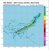
Though the fact is that it hasn't formed yet. It is still medium chance by the JTWC and is a 60% high chance by BOM.

Earlier model runs from the GFS on this system want it to deepen as far down as the 950s, and one run had the 930s not to long ago.
 
The 865 mb run on 96P is real?!?!?!?

Screenshot 2025-04-10 8.56.12 AM.png
 
think he'd mog zelia/alfie?
Well since 8:35 AM EST this morning, 96P has rapidly become become much better defined. I would reckon we will see Tropical Cyclone 29S before the end of the day.

Also the JTWC went from Medium to High chance on 96P.
 
Invest 96P's TCFA from the JTWC:

Screenshot 2025-04-10 12.17.06 PM.png
Screenshot 2025-04-10 12.16.08 PM.png
 
BoM is now issuing Tropical Cyclone Info and warning cones on Tropical Low 29U (Invest 96P per JTWC)

The Tropical Cyclone Techincal Bullietin:


IDW27600
TROPICAL CYCLONE TECHNICAL BULLETIN: AUSTRALIA - WESTERN REGION
Issued by AUSTRALIAN BUREAU OF METEOROLOGY TROPICAL CYCLONE WARNING CENTRE
at: 1910 UTC 10/04/2025
Name: Tropical Low
Identifier: 29U
Data At: 1800 UTC
Latitude: 8.8S
Longitude: 129.6E
Location Accuracy: within 30nm (55 km)
Movement Towards: west southwest (243 deg)
Speed of Movement: 4 knots (8 km/h)
Maximum 10-Minute Wind: 30 knots (55 km/h)
Maximum 3-Second Wind Gust: 45 knots (85 km/h)
Central Pressure: 1002 hPa
Radius of 34-knot winds NE quadrant:
Radius of 34-knot winds SE quadrant:
Radius of 34-knot winds SW quadrant:
Radius of 34-knot winds NW quadrant:
Radius of 48-knot winds NE quadrant:
Radius of 48-knot winds SE quadrant:
Radius of 48-knot winds SW quadrant:
Radius of 48-knot winds NW quadrant:
Radius of 64-knot winds: nm ( km)
Radius of Maximum Winds: nm ( km)
Dvorak Intensity Code: T2.0/2.0/D1.0/18HRS STT:D0.5/06HRS
Pressure of outermost isobar: 1006 hPa
Radius of outermost closed isobar: 60 nm (110 km)
FORECAST DATA
Date/Time : Location : Loc. Accuracy: Max Wind : Central Pressure
(UTC) : degrees : nm (km): knots(km/h): hPa
+06: 11/0000: 9.1S 129.3E: 040 (080): 030 (055): 1000
+12: 11/0600: 9.7S 129.0E: 050 (095): 030 (055): 1001
+18: 11/1200: 10.4S 128.5E: 060 (110): 035 (065): 999
+24: 11/1800: 11.0S 128.1E: 065 (120): 035 (065): 999
+36: 12/0600: 12.2S 127.1E: 085 (155): 035 (065): 999
+48: 12/1800: 13.1S 125.8E: 105 (195): 040 (075): 996
+60: 13/0600: 13.7S 124.5E: 135 (250): 045 (085): 993
+72: 13/1800: 14.1S 123.4E: 150 (280): 050 (095): 989
+96: 14/1800: 14.7S 121.6E: 195 (360): 070 (130): 974
+120: 15/1800: 14.8S 119.8E: 240 (440): 080 (150): 966
REMARKS:
Tropical Low 29U lies over the far northern Timor Sea and has been drifting
generally westward. Pulses of deep convection have maintained a fluctuating CDO
to the SW of the estimated LLCC. There is only fair confidence in the centre
position, which has been biased towards a recent OSCAT pass at 1510 UTC.

Dvorak analysis is based on curved band (0.4 to 0.45 wrap) and shear (estimated
LLCC less than half a degree from CDO) patterns averaged over 3 hours, giving
DTs of 2.5-3.0 with neither pattern clear cut. Final T limited to 2.0 by
constraints, and CI is likewise 2.0. Intensity set at 30 knots extrapolating
from recent scatterometry, chiefly ASCAT 1243 UTC, allowing for a slight
improvement to the pattern since that time.

The system lies near a strong gradient of deep layer shear near the western
periphery of an upper anticyclone, with the current satellite signature
suggesting NE'ly shear is impacting the vertical stacking of the circulation.
Along the forecast track to the southwest, conditions should improve as the
system enters a lower shear channel. Deep tropical moisture and high SSTs
(30-31C) are otherwise in place, and a shortwave upper trough to the SW is
improving poleward outflow and upper divergence. Slow development is forecast
in the short term, with the effects of shear likely to continue to be felt, and
only limited low level forcing on the northern side. In the medium term
development may become more rapid as the system moves into lower deep layer
shear. It should be noted that 29U is a small system and thus prone to rapid
intensity fluctuations as it responds quickly to positive and negative changes
in the environment. It may therefore strengthen more rapidly than forecast if
conditions improve.

A mid-level ridge to the southwest will be the dominant influence on the motion
of 29U over the coming week and will steer the system steadily to the west. In
the shorter term, a mid-level trough extending from eastern Australia will
introduce a southward component to the motion and thus 29U will move southwest
over the weekend. This may bring it close to the Kimberley coast late Saturday
or on Sunday. From about Monday, the influence of the trough will wane and
movement will become more WSW or westward. Around mid-next week, an upper
trough is expected to amplify over southwest WA which may steer the system
towards the WA coast, however there is high uncertainty at this lead time.


Copyright Commonwealth of Australia
==

The next bulletin for this system will be issued by: 11/0130 UTC.
--------------------------------------------------------------------------------------------------------------------------------------------------------------
The Tropical Cyclone Info Bullietin:

IDW24000
Australian Bureau of Meteorology
Tropical Cyclone Warning Centre

TROPICAL CYCLONE INFORMATION BULLETIN
Issued at 2:40 am WST on Friday 11 April 2025

A Tropical Low (29U) was located at 2:00 am AWST near 8.8S 129.6E, that is 425
km north northwest of Darwin and 305 km north northwest of Pirlangimpi, and
moving west southwest at 8 kilometres per hour.

Tropical Low 29U is located to the north-northwest of Darwin, and is forecast
to move southwest, across the Timor Sea over the next few days, while remaining
off the western Top End coast.

29U is expected to develop into a tropical cyclone on the weekend with
increasing risk of coastal impacts for the Kimberley coast from late Saturday.

The next Information Bulletin will be issued at 9:00 am AWST Friday 11 April.
-----------------------------------------------------------------------------------------------------------------
The warning cone from Western Australia:
Screenshot 2025-04-10 3.19.12 PM.png
---------------------------------------------------------------------------------------------------------------------------------
The track map from the Northern Territory:
Screenshot 2025-04-10 3.21.02 PM.png
---------------------------------------------------------------------------------------------------------------------------
And finally, the Ocean Wind Warning:
-----------------------------------------------------
IDW23100

40:2:2:24:09S130E400:11:00
SECURITE

OCEAN WIND WARNING FOR METAREA 10
Issued by the Australian Bureau of Meteorology
Tropical Cyclone Warning Centre
at 1851 UTC 10 APRIL 2025

GALE WARNING

Please be aware, wind gusts can be a further 40 percent stronger than the
averages given here, and maximum waves may be up to twice the height.

SITUATION
At 1800 UTC a Tropical Low was centred within 30 nautical miles of
latitude eight decimal eight south (8.8S)
longitude one hundred and twenty nine decimal six east (129.6E)
Recent movement : west southwest at 4 knots
Maximum winds : 30 knots
Central pressure: 1002 hPa
The low is expected to develop into a tropical cyclone in the next 36 to 48
hours.

AREA AFFECTED
Within 50 nautical miles in SE quadrant
and within 40 nautical miles in SW quadrant

FORECAST
Maximum winds to 30 knots near the centre increasing to 35 knots by 1800 UTC 11
April.

From 1200 UTC 11 April winds above 34 knots within 50 nautical miles in SE
quadrant
and within 40 nautical miles in SW quadrant with rough seas and moderate
swell.

Forecast positions
At 0600 UTC 11 April: Within 50 nautical miles of 9.7 south 129.0 east
Central pressure 1001 hPa.
Winds to 30 knots near centre.
At 1800 UTC 11 April: Within 65 nautical miles of 11.0 south 128.1 east
Central pressure 999 hPa.
Winds to 35 knots near centre.

REMARKS
All ships in the area please send weather reports every three hours.
Regular weather observing ships use normal channels.
Other ships please use email to [email protected].

Next warning will be issued by 0100 UTC 11 April 2025.

AUSTRALIAN BUREAU OF METEOROLOGY
TROPICAL CYCLONE WARNING CENTRE
 
I'm sorry, but I'm seeing HAFS-A and the parent making this thing a C3 at most? Did they back off substantially since this morning or something? No shot this thing goes sub-900 IMO, let alone sub-870.
 
I'm sorry, but I'm seeing HAFS-A and the parent making this thing a C3 at most? Did they back off substantially since this morning or something? No shot this thing goes sub-900 IMO, let alone sub-870.
I mean it is near and approaching the warmest SSTs in the entire SHEM at the moment. If the wind shear can weaken, I could see it going 920-945 at best unless it pulls a Inigo.
 
I mean it is near and approaching the warmest SSTs in the entire SHEM at the moment. If the wind shear can weaken, I could see it going 920-945 at best unless it pulls a Inigo.
Interestingly, Inigo formed on April 1st, 2003 and peaked at 140 kts (160 mph) with a pressure of 898 mbs according to the JTWC best track on it.

Screenshot 2025-04-10 3.40.28 PM.png
 
Invest 96P (Tropical Low 29U) has yet to form into a tropical cyclone. However it is expected to become sometime likely within the next 24-48 hours, if not sooner. The JTWC has maintained it as a high-chance invest, while the BoM has upped the chances for it to a 65% high chance.

We have another Australian Region signal which is located in the Arafura Sea and it is likely to move into the Gulf of Carpentaria. The BoM has mark this signal as Tropical Low 30U.

We are also watching the eastern South Pacific and far eastern Australian Region for possible storm formation, though no organized signals have showed up yet.
 
The ACTF has updated on Zoom Earth, and Invest 96P is now at 35 kts (40 mph). I would expect Invest 96P to be designated as Tropical Cyclone 29S here soon.
 
Invest 96P (Tropical Low 29U) is now Tropical Cyclone 29S!


Tropical Storm TWENTYNINE
Updated April 11, 2025 at 18:00 UTC
Located at 10.6°S, 128.1°E
Minimum Pressure: 1000 mb
Maximum Winds: 35 kt
Radius of Maximum Wind: N/A nm
Environmental Pressure: N/A mb
Storm Radius: N/A nm
Satellite LoopRadar LoopLatest GFS ForecastLatest ECMWF Forecast

Screenshot 2025-04-11 3.21.49 PM.png
Screenshot 2025-04-11 3.23.46 PM.png
Edit: one more storm and we reach 30 storms in the SHEM for the first time in 26 years. It all depends on the next tropical low that the BoM has marked: Tropical Low 30U.

The last time we reached 29 storms in the SHEM season was 4 years ago, in the 2020-21 season.
 
So we are now at this:

01S Ancha
02S Bheki
03S Robyn
04S Chido
05S Five
06P Six

07S Dikeledi
08P Pita
09S Nine

10S Sean
11S Faida
12S Elvis

13S Vince
14S Taliah
15P Fifteen
16P Sixteen

17S Zelia
18P Alfred

19P Rae
20S Bianca
21P Seru
22S Garance
23S Honde
24S Ivone
25S Jude
26S Twenty-Six
27S Courtney
28S Dianne
29S Twenty-Nine
 
Hey @Atlantic we are now at 102 consecutive days without the first West PAC system. Only the 18z GFS this evening is showing a potential tropical system in the West Pacific by April 29th. If we get through May 10th without the first system, that'll be 129 days. To get into the top 4 years, we'll have to go until May 25th (144 days).

Here's the Top 4 years consecutive without having the first tropical system in West PAC:

1. 1998: 187
2. 1983: 174
3. 1984: 158
4. 2024: 142
Haven't the last couple years been unusually quiet in the West Pacific, despite seeing storms like Goni, Surigae, Mawar, etc?
 
Haven't the last couple years been unusually quiet in the West Pacific, despite seeing storms like Goni, Surigae, Mawar, etc?
It has. In fact, if you look back, the last above normal West Pacific season (by total ACE) was in 2018. Average ACE is 301.
 
Hey @Atlantic we are now at 102 consecutive days without the first West PAC system. Only the 18z GFS this evening is showing a potential tropical system in the West Pacific by April 29th. If we get through May 10th without the first system, that'll be 129 days. To get into the top 4 years, we'll have to go until May 25th (144 days).

Here's the Top 4 years consecutive without having the first tropical system in West PAC:

1. 1998: 187
2. 1983: 174
3. 1984: 158
4. 2024: 142
2024 was odd, but 2023 was odder.

2024 I could understand, with a strong El Niño degrading into a neutral phase.

2023 is an anomaly to me. A strong El Niño, but the season was the second least active on record.
Heck, the ATL was the opposite; producing a near-hurricane in January and the turning around and producing 19 additional storms by the end of October.


102 days now, what has been happening to the WPAC these past five years?
 
29S remains unnamed as of now by the BoM.

We now have a medium-chance invest by the JTWC in the SPAC in Invest 98P;
IMG_5600.jpeg
We have Invest 97P by the JTWC in the Australian Region; 97P is Tropical Low 30U by BoM.
IMG_5601.jpeg
We also now have a newly designated Invest 99S at 5.06S, 84.54W; located inside the SWIO boundaries.
IMG_5602.jpeg
And finally; the current forecast cone on 29S;
IMG_5599.png
With 97P, 98P and 99S; the race to 30 JTWC-designated TCs in the SHEM is on. It is also possible all three invests could form, which would bring us to 32 SHEM storms for 2024-25 season.
 
First model guidance on 99S;
 

Attachments

  • IMG_5604.jpeg
    IMG_5604.jpeg
    446 KB · Views: 0
Back
Top