- Admin
- #81
- Messages
- 3,611
- Reaction score
- 3,415
- Location
- Fayetteville, AR
- Special Affiliations
- SKYWARN® Volunteer
So agreed... especially if the next storm heads toward TexasThis thing seems like a waste of a storm name.
Follow along with the video below to see how to install our site as a web app on your home screen.
Note: This feature may not be available in some browsers.
So agreed... especially if the next storm heads toward TexasThis thing seems like a waste of a storm name.
I see what you did there.So agreed... especially if the next storm heads toward Texas
I think there will be some organization of the disturbance east of the Lesser Antilles over the next few days. Perhaps it can get organized enough to be labeled an invest, and run other models on it.
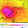
There may finally be some tropical development to be concerned about for the US. GFS ensembles, CMC, EURO, and Navy showing organization of a tropical wave as it gets closer to home. 1st week of September is when I’d look for a possible impact.
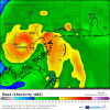
maybe finally things will get interesting out there... though I do wish more models than the Euro would develop the Gulf already
3 named storms showing on most models by next week. Florence, Helene, and Issac.
Yeah, the NHC has no set criteria when it comes to retirement. Hurricane Isaac is one of only a few multi-billion dollar storms that was not retired. It was the last hurricane I rode out in Louisiana and for a category 1, that sucker packed a punch. Likely because it stalled on the coast for about 12 hours and was strengthening at landfall.Huh. TIL that Issac isn't retired. Kind of shocking considering that 2012's rendition of it was devastating for LA.