• Welcome to TalkWeather!
    We see you lurking around TalkWeather! Take the extra step and join us today to view attachments, see less ads and maybe even join the discussion.
    CLICK TO JOIN TALKWEATHER

2018 Atlantic Hurricane Season

akt1985

Member
Messages
1,009
Reaction score
509
Location
Madison, Alabama
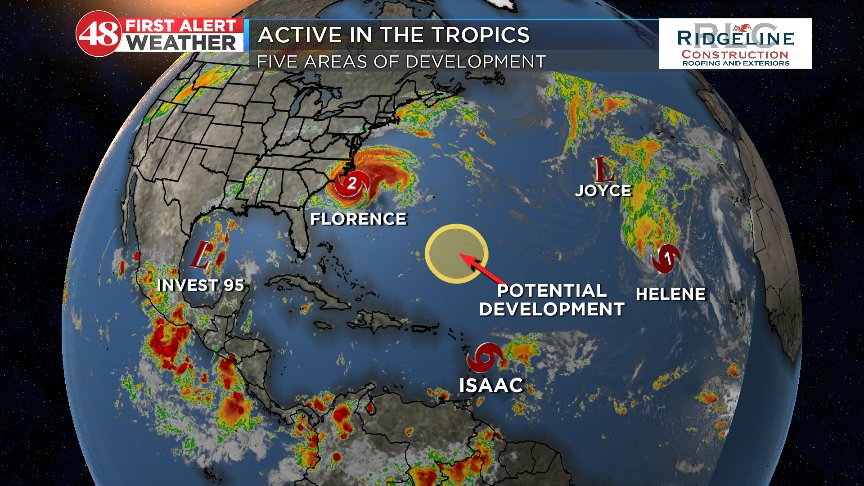
If tropical depressions eight and nine become tropical storms at the same time, how will the National Hurricane Center decide which system gets which name? Since Tropical Depression Nine is more likely to wind up as a named storm that will be retired next year versus tropical depression eight near the Cabo Verde Islands, do you think Tropical Depression Nine would become Helene and Tropical Depression Eight becomes Issac since right now Tropical Depression Eight is likely to be a fish storm and the World Meteorological Association can avoid having to come up a replacement name for yet another I named storm in 2019 since the World Meteorological Association is running out of I names?
 

Mike S

Administrator
Staff member
Administrator
Moderator
PerryW Project Supporter
Messages
1,991
Reaction score
1,115
Location
Meridianville, Al
Special Affiliations
  1. SKYWARN® Volunteer
Noticed this when check the NHC site for Florence information.....

1. The combination of an upper-level trough and a tropical wave over
the northwestern Caribbean Sea is producing a large area of
disorganized showers and thunderstorms between Cuba and Honduras.
The disturbance is forecast to move slowly west-northwestward to
northwestward across the northwestern Caribbean Sea and the
Yucatan peninsula during the next couple of days, with little or no
development expected due to unfavorable upper-level winds and land
interaction. However, upper-level winds are forecast to become a
little more conducive for development when the system moves across
the western Gulf of Mexico Wednesday through Friday.
* Formation chance through 48 hours...low...near 0 percent.
* Formation chance through 5 days...low...30 percent.
 

Taylor Campbell

Moderator
Moderator
PerryW Project Supporter
Messages
2,102
Reaction score
2,189
Location
Wedowee, AL
Special Affiliations
  1. SKYWARN® Volunteer
There could be 5 named storms by the end of this week.
 

WesL

"Bill, I'm talkin' imminent rueage"
Staff member
Administrator
Moderator
Sustaining Member
Messages
3,344
Reaction score
2,614
Location
Fayetteville, AR
Special Affiliations
  1. SKYWARN® Volunteer
I just want one ride with them.


Mike S

Administrator
Staff member
Administrator
Moderator
PerryW Project Supporter
Messages
1,991
Reaction score
1,115
Location
Meridianville, Al
Special Affiliations
  1. SKYWARN® Volunteer
Dm9_0LpW0AAo-_t.jpg
 

rolltide_130

Member
Messages
828
Reaction score
378
Location
Harvest, Alabama
Special Affiliations
Looks like we may hit a lull after Florence as Isaac has officially transitioned to a remnant low and Joyce and Helene are meandering their way towards Europe.

There's still some time, but the Cape Verde window may be closing for the season within the next two or so weeks before we move further W to the Caribbean and Gulf being our hotspots. Those can produce some nasty ones though (Matthew, Wilma), so we are not anywhere close to out of the woods yet even if the Cape Verde window closes.
 

rolltide_130

Member
Messages
828
Reaction score
378
Location
Harvest, Alabama
Special Affiliations
The Atlantic decided to take a week off after Florence but she is awakening with a vengeance including another potential Cape Verde system that's at a more typical latitude than Florence was. This could bear watching over the next week or so.

Also the two systems off the east coast are bizzare. I think the red one is technically the remnant low of Florence so I don't know what the process is for naming that if it indeed is Florence's remains and it become a TC again.

two_atl_5d0.png
 

Mike S

Administrator
Staff member
Administrator
Moderator
PerryW Project Supporter
Messages
1,991
Reaction score
1,115
Location
Meridianville, Al
Special Affiliations
  1. SKYWARN® Volunteer
actually, I think it is the yellow x that is some sort of Florence remnant. IIRC, this was even predicted by some of the models leading up to landfall. I'd have to go back through the thread to see for sure.
 

JayF

Technical Administrator
Staff member
Administrator
Moderator
Sustaining Member
Technical Admin
Messages
1,624
Reaction score
878
Location
Hartselle, al
HAM Callsign
KB4JCS
Subtropical storm Leslie is not a threat to land at this time.
 

Kory

Member
Messages
4,928
Reaction score
2,119
Location
Tuscaloosa, Alabama
Indications of lowering pressures in the Caribbean in the 5-10 day range with Euro/CMC ensembles. Some pretty significant troughing developing over the Central U.S. will probably will whatever forms down there into the Gulf. At the very least, it looks like a surge of tropical moisture in the 5-10+ day period.
^^^^
 

Taylor Campbell

Moderator
Moderator
PerryW Project Supporter
Messages
2,102
Reaction score
2,189
Location
Wedowee, AL
Special Affiliations
  1. SKYWARN® Volunteer

I’m with ya! I see it too. Thunderstorm activity is pretty active down there. We may have a named system by the end of this week, and like you said, the pattern appears to support a track into the Gulf!
 

WesL

"Bill, I'm talkin' imminent rueage"
Staff member
Administrator
Moderator
Sustaining Member
Messages
3,344
Reaction score
2,614
Location
Fayetteville, AR
Special Affiliations
  1. SKYWARN® Volunteer
I’m with ya! I see it too. Thunderstorm activity is pretty active down there. We may have a named system by the end of this week, and like you said, the pattern appears to support a track into the Gulf!

Of course. I'm sailing out of Mobile next week.
 

WesL

"Bill, I'm talkin' imminent rueage"
Staff member
Administrator
Moderator
Sustaining Member
Messages
3,344
Reaction score
2,614
Location
Fayetteville, AR
Special Affiliations
  1. SKYWARN® Volunteer
NO! GO AWAY! We are sailing from Mobile on Thursday. Need this to dissipate. The only reason I'm taking this cruise is that we didn't make it to Cozumel in late May/early June thanks to Tropical Storm Alberto.


1. A broad low pressure area centered near the northeastern coasts of
Nicaragua and Honduras is producing an extensive area of
disorganized clouds and thunderstorms over the central and western
Caribbean Sea, as well as portions of Central America. While
surface pressures are relatively low in the area, upper-level winds
are currently not favorable for tropical cyclone formation.
Environmental conditions could become less hostile by late this
weekend or early next week, and a tropical depression could form as
the system moves slowly northwestward across the northwestern
Caribbean Sea and the southern Gulf of Mexico.
* Formation chance through 48 hours...low...near 0 percent.
* Formation chance through 5 days...medium...40 percent.

1538679276485.png
 

Kory

Member
Messages
4,928
Reaction score
2,119
Location
Tuscaloosa, Alabama
Pretty good chance we will be dealing with a tropical system in the Gulf in October. The signs have been here for a while now.
 

Taylor Campbell

Moderator
Moderator
PerryW Project Supporter
Messages
2,102
Reaction score
2,189
Location
Wedowee, AL
Special Affiliations
  1. SKYWARN® Volunteer
Please come into my backyard like I’ve seen some model runs do with it.
 

WesL

"Bill, I'm talkin' imminent rueage"
Staff member
Administrator
Moderator
Sustaining Member
Messages
3,344
Reaction score
2,614
Location
Fayetteville, AR
Special Affiliations
  1. SKYWARN® Volunteer
Is that you Nadine?

1539030506906.png
 

Mike S

Administrator
Staff member
Administrator
Moderator
PerryW Project Supporter
Messages
1,991
Reaction score
1,115
Location
Meridianville, Al
Special Affiliations
  1. SKYWARN® Volunteer
Poor Leslie. It has been 16 days since her initial advisory and is now a Cat 1 Hurricane yet she never merited a thread of her own.
 

warneagle

Member
Messages
3,729
Reaction score
3,208
Location
Arlington, VA
Special Affiliations
  1. SKYWARN® Volunteer
She might get one if she gets close to breaking the longevity record. She's the Atlantic's answer to John in the Pacific in '87: do nothing but do it for a really really long time.
 
Logo 468x120
Back
Top