Navigation
Install the app
How to install the app on iOS
Follow along with the video below to see how to install our site as a web app on your home screen.
Note: This feature may not be available in some browsers.
More options
-
Welcome to TalkWeather! We see you lurking around TalkWeather! Take the extra step and join us today to view attachments, see less ads and maybe even join the discussion. CLICK TO JOIN TALKWEATHER
You are using an out of date browser. It may not display this or other websites correctly.
You should upgrade or use an alternative browser.
You should upgrade or use an alternative browser.
Significant Tornado Events
- Thread starter locomusic01
- Start date
Putting my reply in this thread since I think we can all agree that 3/14-3/15 etched itself a place in the significant tornado event book.Even the northern or southern high risks of 3/31/23 (taken individually) didn't quite achieve a look like that. Certainly none of the Plains high risks since 2012 have.
That radar presentation is exactly how I imagine some of the higher end historical outbreaks would look on WSR 88D. A Northeast-to-Southwest Oriented line of pure discrete supercells, all very obviously tornadic. Very textbook, aesthetically pleasing radar image.
Of course, when you get a cooperating storm mode in an area that real time mesoanalysis was showing SCP over 30, that’s the result.
Last edited:
Kds86z
Member
Exactly. Classic line of tornadic supercells perfectly spread apart. Very rare.Putting my reply in this thread since I think we can all agree that 3/14-3/15 etched itself a place in the significant tornado event book.
That radar presentation is exactly how I imagine some of the higher end historical outbreaks would look on WSR 88D. A Northeast-to-Southwest Oriented line of pure discrete supercells, all very obviously tornadic. Very textbook, aesthetically pleasing radar image.
Of course, when you get a cooperating storm mode in an area that real time mesoanalysis was showing SCP over 30, that’s the result.
Central Ohio Wx
Member
Just finished up the Wikipedia page for the Rockford tornado of 1928. Funny enough, the NWS rated it an EF3 in the Damage Assessment Toolkit and on its website despite it happening in the 1920s. It’s (iirc) the oldest tornado to be rated on the EF scale. The same thing happened to the Depauw F5, Belvidere F4, both Nashville F3s, and the Brandenburg F5.
Kds86z
Member
following that event with yall here was crazy. Multiple pds warnings and tornado warnings. Hard to keep track. Of course it took until after dark before it took off and kept telling yall to hold up LOL because tornado warnings were hour or hours before anything hit the ground but SPC said it wouldn’t be until after dark.Exactly. Classic line of tornadic supercells perfectly spread apart. Very rare.
Last edited:
CheeselandSkies
Member
Just finished up the Wikipedia page for the Rockford tornado of 1928. Funny enough, the NWS rated it an EF3 in the Damage Assessment Toolkit and on its website despite it happening in the 1920s. It’s (iirc) the oldest tornado to be rated on the EF scale. The same thing happened to the Depauw F5, Belvidere F4, both Nashville F3s, and the Brandenburg F5.
Pretty sure they're not supposed to be doing that.
Central Ohio Wx
Member
You'd think it's just a limitation with the DAT only allowed to input EF scale parameters, but then they go and legitimately rate it "EF/F3+" on the official website.Pretty sure they're not supposed to be doing that.
AJS
Member
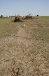
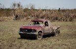
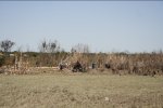
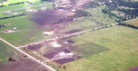
The Westminster, TX tornado of May 9, 2006 was NOT an “ F3. “
Also wanted to give a warm welcome back this forum after a bit of a mental health break. Life can get kinda crazy at times, especially during senior year of high school, but thankfully doing a lot better and got some great research and images ready to share with all of y’all.
N0mz
Member
The last years of the classic fajita scale got almost as bad as the stretch we're currently in with the EF scaleView attachment 46448View attachment 46449View attachment 46445View attachment 46446
The Westminster, TX tornado of May 9, 2006 was NOT an “ F3. “
Also wanted to give a warm welcome back this forum after a bit of a mental health break. Life can get kinda crazy at times, especially during senior year of high school, but thankfully doing a lot better and got some great research and images ready to share with all of y’all.
Kds86z
Member
Sorry to hear @AJS and as always appreciate your honest and authenticity.View attachment 46448View attachment 46449View attachment 46445View attachment 46446
The Westminster, TX tornado of May 9, 2006 was NOT an “ F3. “
Also wanted to give a warm welcome back this forum after a bit of a mental health break. Life can get kinda crazy at times, especially during senior year of high school, but thankfully doing a lot better and got some great research and images ready to share with all of y’all.
Kds86z
Member
AJS
Member
Man, cannot believe it’ll be ten years since that day. Vividly remember watching TWC as it was happening.
Kds86z
Member
warneagle
Member
idk, I always thought the best modern analog was Hackleburg, just based on how people described it
Kds86z
Member
Apparently survivors of tri state were shown tornado photos and they said this one. But yeah .idk, I always thought the best modern analog was Hackleburg, just based on how people described it
Central Ohio Wx
Member
Does anyone know how to open drafts? I had one saved for September 11 but can’t open it as a test.
From Trey’s case study on the 3/14 outbreak, a RAP proximity sounding taken near the Fifty-Six Arkansas long track EF4. Very rare environment those storms were in that night.
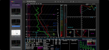
Also didn’t realize a cold front/psuedo dry-line was the main boundary initiator that night for the supercells. There was a small temperature gradient on both sides, so the forcing was more subtle. Kind of like the cold front on Palm Sunday 1965 and 5/31/85. I always thought it was a straight up dryline the night of the 14th.
I was ping ponging back and forth with each model run from nothing burger to high end outbreak. Moisture issues, lead wave placement, mixing etc. I distinctly remember @Clancy and @JPWX being insistent throughout the week leading up to that Friday that the synoptics were just so overwhelming there was bound to be some kind of tornado outbreak somewhere. They nailed it.
I’m always interested in these case studies because it seems like your higher end outbreaks take instances that would easily stifle any other outbreak and just push them aside. 4/3/74 had a large MCS move through the outbreak areas not even 4 hours before initiation time and had decently overcast skies over the norther portion. 4/27/11 and it’s two morning rounds. 5/3/99 with a cirrus canopy and dual dryline structure. I would laugh if you told me an area with high 30s to mid 50s dew points the late morning/early afternoon of an event later had multiple, high end discrete supercells rolling through it. That’s exactly what happened in Northern Arkansas/Southern Missouri on 3/14.
Kds86z
Member
Don’t forget @UK_EF4 calling for a violent tornado in discussion and was pretty point on. Evn SPC wasn’t saying V word. However I think they said intense tornadoes though.From Trey’s case study on the 3/14 outbreak, a RAP proximity sounding taken near the Fifty-Six Arkansas long track EF4. Very rare environment those storms were in that night.
View attachment 46515
Also didn’t realize a cold front/psuedo dry-line was the main boundary initiator that night for the supercells. There was a small temperature gradient on both sides, so the forcing was more subtle. Kind of like the cold front on Palm Sunday 1965 and 5/31/85. I always thought it was a straight up dryline the night of the 14th.
I was ping ponging back and forth with each model run from nothing burger to high end outbreak. Moisture issues, lead wave placement, mixing etc. I distinctly remember @Clancy and @JPWX being insistent throughout the week leading up to that Friday that the synoptics were just so overwhelming there was bound to be some kind of tornado outbreak somewhere. They nailed it.
I’m always interested in these case studies because it seems like your higher end outbreaks take instances that would easily stifle any other outbreak and just push them aside. 4/3/74 had a large MCS move through the outbreak areas not even 4 hours before initiation time and had decently overcast skies over the norther portion. 4/27/11 and it’s two morning rounds. 5/3/99 with a cirrus canopy and dual dryline structure. I would laugh if you told me an area with high 30s to mid 50s dew points the late morning/early afternoon of an event later had multiple, high end discrete supercells rolling through it. That’s exactly what happened in Northern Arkansas/Southern Missouri on 3/14.
Last edited:

