Welp, time to get started… Tornado Warning in Nebraska now as well.
View attachment 45239
829
WFUS53 KLBF 190121
TORLBF
NEC017-190200-
/O.NEW.KLBF.TO.W.0024.250719T0121Z-250719T0200Z/
BULLETIN - EAS ACTIVATION REQUESTED
Tornado Warning
National Weather Service North Platte NE
821 PM CDT Fri Jul 18 2025
The National Weather Service in North Platte has issued a
* Tornado Warning for...
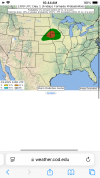
West central Brown County in north central Nebraska...
* Until 900 PM CDT.
* At 820 PM CDT, a severe thunderstorm capable of producing a tornado
was located 7 miles south of Johnstown, or 13 miles southwest of
Ainsworth, moving south at 15 mph.
HAZARD...Tornado and half dollar size hail.
SOURCE...Radar indicated rotation.
IMPACT...Flying debris will be dangerous to those caught without
shelter. Mobile homes will be damaged or destroyed.
Damage to roofs, windows, and vehicles will occur. Tree
damage is likely.
* This tornadic thunderstorm will remain over mainly rural areas of
west central Brown County, including the following locations...
Moon Lake.
This includes Highway 20 between mile markers 233 and 238.
PRECAUTIONARY/PREPAREDNESS ACTIONS...
TAKE COVER NOW! Move to a basement or an interior room on the lowest
floor of a sturdy building. Avoid windows. If you are outdoors, in a
mobile home, or in a vehicle, move to the closest substantial shelter
and protect yourself from flying debris.
&&
LAT...LON 4233 9985 4232 10016 4237 10017 4253 10019
4254 10018 4259 9994
TIME...MOT...LOC 0120Z 349DEG 11KT 4247 10009
TORNADO...RADAR INDICATED
MAX HAIL SIZE...1.25 IN