
So when's the moderate risk for the coastline going to come out? It's inevitable lol
Navigation
Install the app
How to install the app on iOS
Follow along with the video below to see how to install our site as a web app on your home screen.
Note: This feature may not be available in some browsers.
More options
-
Welcome to TalkWeather! We see you lurking around TalkWeather! Take the extra step and join us today to view attachments, see less ads and maybe even join the discussion. CLICK TO JOIN TALKWEATHER
You are using an out of date browser. It may not display this or other websites correctly.
You should upgrade or use an alternative browser.
You should upgrade or use an alternative browser.
Severe WX Severe Weather Threat January 23-25, 2023
- Thread starter Lake Martin EF4
- Start date
KevinH
Member
The last D2 already came out, so tomorrow’s D1 should be MOD if they upgradeSo when's the moderate risk for the coastline going to come out? It's inevitable lol
Wut....?.png")
CheeselandSkies
Member
This is a tricky forecast. Another one of those highly conditional setups where the shear is there for something very bad, IF a storm or two can find a sweet spot of "just enough" instability to keep the updraft from being sheared apart. The majority of these don't produce, but when they do...
...reminds me of the Sunset Beach, NC high-end EF3 of February 15-16, 2021 that killed three people, touching down in the middle of the night, with no watch or warning issued until it was already in progress. Sufficient instability wasn't expected to exist on land as a surface low and associated fronts moved up the coast, but just a small pocket was enough with the other parameters in place near the triple point that night.
...reminds me of the Sunset Beach, NC high-end EF3 of February 15-16, 2021 that killed three people, touching down in the middle of the night, with no watch or warning issued until it was already in progress. Sufficient instability wasn't expected to exist on land as a surface low and associated fronts moved up the coast, but just a small pocket was enough with the other parameters in place near the triple point that night.
Last edited:
Woa
TileDude
Member
Wind advisories out from the gulf coast to Nashville. 40 to 50 mph gusts from gradient winds. Going to be a noisy night even outside of the areas receiving severe storms.
One thing I've noticed in lower instability events is that sometimes very high vertical velocity, (synoptic lifters, mesoscale features) can negate some of the lack of instability. Sure you'll end up with a wispy tornsdo but it'll be rather strong. It's always a hard medium to figure out whats enough, skip talbot has hit the nose on some of these issues and really cashed out on days where many people wouldn't chase due to questionable mositure.This is a tricky forecast. Another one of those highly conditional setups where the shear is there for something very bad, IF a storm or two can find a sweet spot of "just enough" instability to keep the updraft from being sheared apart. The majority of these don't produce, but when they do...
...reminds me of the Sunset Beach, NC high-end EF3 of February 15-16, 2021 that killed three people, touching down in the middle of the night, with no watch or warning issued until it was already in progress. Sufficient instability wasn't expected to exist on land as a surface low and associated fronts moved up the coast, but just a small pocket was enough with the other parameters in place near the triple point that night.
We've had many relatively strong tornadoes in lower instability thresholds in the south, numerous ef4s and ef3s. I'm not sure whether it's the lack of dry air we have in the south that makes this possible or what. Probably other weather enthusiasts that have studied some of this but the souths environments in the winter, a range of 800-1500sb cape is generally enough to support a violent tornado in Alabama with other supporting factors.
Another things that people don't recognize unless you live in the deep south is that most.of our tornado days are not your typical discrete convection ones. They end up being a sloppy quick strong tornado from a "kinky" broken line. It's quite phenomenal how flexible the south is in terms of producing with non ideal setups.
Last edited:
It'd be interesting if just based on data on some of your major factors if we grouped thresholds to a certain standard in winter events compared to spring or fall events.
ashtonlemleywx
Member

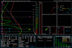
This sounding from 18z HRRR for Houston TX is nucking futs.
MattPetrulli
Member
I probably wouldn't go 15% yet at least for supercell tornado potential. I don't think there is nearly enough confidence to go 15% for that. HOWEVER, I do think a 15% can verify for QLCS tors. More than everything, I think tomorrow can be a QLCS galore with the extreme shear present. Supercell threat seems too conditional for that to be the main reason for a moderate upgrade.
That calculation of STP, amongst other things, looks very off.
It's his own formula for 0-100 meters,That calculation of STP, amongst other things, looks very off.
I'd keep a eye on it though his model has a decent track record.
If anything I think it highlights the extremely sheared low levels. Which is important for violent tornadoes.
Last edited:
CheeselandSkies
Member
This sounding from 18z HRRR for Houston TX is nucking futs.
Looks convectively contaminated (as in, the sounding was taken from within a modeled storm's updraft). That will artificially inflate your SRH values. The tell is the pink lines on the bottom left. I'm not really sure what the threshold is, but when they extend that far to the right it's a sure sign of contamination.
First ever High Wind Watch issued for Mobile Alabama area on record and the first High Wind Warning issued for parts of Southeast Texas in the month of January. The last High Wind Warning issued for Southeast Texas area was back in April 2010.
CheeselandSkies
Member
Yep definitely. We have seen time and time again what extreme low level shear (which I think is fair to say we have present tomorrow) can do to a QLCS. I doubt this time will be much different to be honest.I probably wouldn't go 15% yet at least for supercell tornado potential. I don't think there is nearly enough confidence to go 15% for that. HOWEVER, I do think a 15% can verify for QLCS tors. More than everything, I think tomorrow can be a QLCS galore with the extreme shear present. Supercell threat seems too conditional for that to be the main reason for a moderate upgrade.
CheeselandSkies
Member
The "sweet spot" in this event is going to be so small, it's hard to get a representative CAM sounding of the pre-storm environment that's NOT convectively contaminated, because the environment that will fuel the storms advects in JUST ahead of them. Again, high bust potential but high ceiling if it doesn't.
If they do decide to go Moderate Risk for tomorrow, my guess is it would be more geared towards widespread damaging winds
Best bet is EHI. When it's hard to or worried about contaminationThe "sweet spot" in this event is going to be so small, it's hard to get a representative CAM sounding of the pre-storm environment that's NOT convectively contaminated, because the environment that will fuel the storms advects in JUST ahead of them. Again, high bust potential but high ceiling if it doesn't.