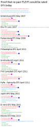
Ok here is what it seems i could find (if there's any images before 1984 it would help) , anyhow
Black line = Core
White line = Possible core
Light Blue outline = Possible Path
Blue outline = EF0-EF3 damage mark
Red outline = EF2-EF5 damage mark
Tornado 1
View attachment 15493
Name: Lac monredon Tornado
Location:Sheerway Canada
Path Width:1.24 mile
F rating:F0-F3
Path Lenght:9.95-17.78 miles
notes: one of the only 2 tornadoes that went over a mile wide and the only tornado that seem to have hit a populated area.
Tornado 2
View attachment 15494
Name: Lac moorehead Tornado
Location: (middle of nowhere)Canada
Path Width:0.5-0.53 mile
F rating:F2-F5
Path Lenght:3.11-11.13 miles
Notes:likely first EF2+ tornado of the bunch.
Tornado 3
View attachment 15495
Name: Lac Kondiaronk
Location: (middle of nowhere)Canada
Path Width:0.21-0.32 mile
F rating:F2-F5
Path Lenght:1.56-6.03 miles
notes:starting could be downburst damage?
Tornado 4
View attachment 15496
Name: Lac Cox - Lac beezwhanger - Lac Nalzen Tornado
Location: (middle of nowhere)Canada
Path Width:0.8 mile
F rating:F2-F5
Path Lenght:18.7-23.27 miles
notes: seems to be from a second supercell
Tornado 5
View attachment 15497
Name: Lac Valduc - South Lac Cleghorn Tornado
Location: (middle of nowhere)Canada
Path Width:0.37 mile
F rating:F2-F5
Path Lenght:5.12 miles
notes:might of been on the ground the same time as tornado 7
Tornado 6
View attachment 15498
Name: Lac Alvignac - Lac Titch Tornado
Location: (middle of nowhere)Canada
Path Width:0.17-0.21 mile
F rating:F0-F3
Path Lenght:1.61-5.53 miles
notes:might of been on the ground the same time as tornado 7
Tornado 7
View attachment 15499
Name: Lac Cleghorn - Lac Silly - Lac Tonio Tornado
Location:North of Manawan Canada
Path Width:1.26-1.28 mile
F rating:F2-F5
Path Lenght:110.31-117.8 miles (note for later)
notes:will post more detail later.
Tornado 8
View attachment 15500
Name: Lac Chain - Lac du Voilier - Lac Buisson Tornado
Location: (middle of nowhere)Canada
Path Width:0.78 mile
F rating:F2-F5
Path Lenght:22.1-24.42 miles
notes:likely second tornado of the second supercell.
Tornado 9
View attachment 15501
Name: Petit Lac Gauthier Tornado
Location: (middle of nowhere)Canada
Path Width:0.46 mile
F rating:F2-F5
Path Lenght:5.12 miles
notes:did a upsidown V shape path (similar to moore 2013 loop)
more info on possible other tornadoes and Tornado number 7 later on