• Welcome to TalkWeather!
    We see you lurking around TalkWeather! Take the extra step and join us today to view attachments, see less ads and maybe even join the discussion.
    CLICK TO JOIN TALKWEATHER
Messages
2,231
Reaction score
2,822
Location
Missouri
I've posted about Hackleburg many times before, but I found yet more impressive damage shots that I couldn't help but share.
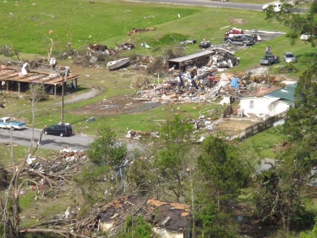
Here's the one house that was swept away before the tornado reached Hackleburg, becoming the first EF5 damage point. Tim Marshall felt this damage point only deserved an EF4 rating, but it was officially rated EF5 by the survey teams.
Hackleburg%2BTornado%2B4-27-11015.jpg


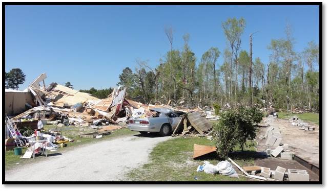
Some extremely impressive vehicle damage. Note the car on the left... or what's left of it, at least.
DF4QPUUOFJG3VJ7U2WGKINIOVU.jpg


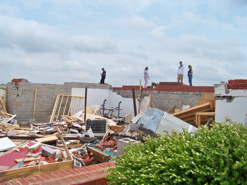
Brick home swept clean with what appears to be ground scouring in the background:


Numerous homes were swept away along Highway 43 S as the tornado entered Hackleburg. EF5 rated damage occurred there, but I haven't been able to find any photos of these homes, not even aerials. Atlantic Group did take aerial photos of this area but I can't find them on any search engine so they're probably behind a paywall of some sort. Naturally...

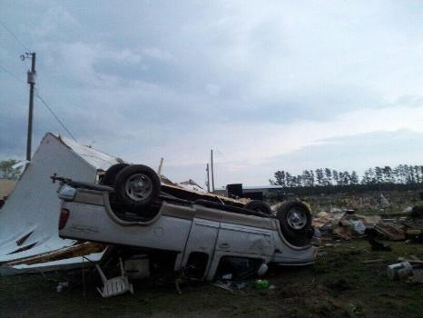
And I'll post this one too; I'm not actually sure what Super Outbreak tornado this is from since the photo isn't labeled, but it's extreme vehicle damage:

If only we could find a picture/article about the car carried a mile and landing in the pond of the farmer and a high-quality picture of the brick home in Oak Grove that was swept away...
 
  • Like
Reactions: CAL

buckeye05

Member
Messages
3,164
Reaction score
4,720
Location
Colorado
Yes, the angle of the crack suggests that it’s a wedge crack or “corner pop” which forms on the corner of many homes in the Midwest. It was likely a weak point that the tornado winds exploited.
See this is why I love this forum. Learned something new that I’ll keep in mind from now on.
 

buckeye05

Member
Messages
3,164
Reaction score
4,720
Location
Colorado
I just found this short 15 minute documentary about the 1964 Anchor Bay, MI F4. The tornado itself wasn't "special" in the grand scheme of things, but I thought some might still find the video interesting. I thought the witnesses descriptions of the massive black wedge rolling towards them were kinda creepy.


I could be wrong about this, but looking through tornado event records, it sure seems like violent tornadoes in Michigan used to be significantly more common. It's pretty much unheard of in more recent times.
 
Messages
2,231
Reaction score
2,822
Location
Missouri
I could be wrong about this, but looking through tornado event records, it sure seems like violent tornadoes in Michigan used to be significantly more common. It's pretty much unheard of in more recent times.
Violent tornado outbreaks in the Upper Midwest seem to have been much more common up until the 1960s or so. I'll have to dig for it, but there was some article on extremeplanet that showed how lots of tornadic activity was recorded throughout the Midwest (Lower and Upper) and Dixie Alley up until the 1970s, when the bulk of tornadic activity shifted to the Great Plains area. And now, within the past decade or so, Dixie Alley is the new Tornado Alley, it seems. Perhaps this kind of cyclical nature of tornado hotspots has always happened but not enough records have been kept to fully demonstrate it yet.
Michigan, Minnesota and Wisconsin had a ton of real violent tornadic events in the past, especially the 1950s and 1960s then it just seems to have tapered off there...
 

atrainguy

Member
Messages
749
Reaction score
1,072
Location
Linden, MI
I could be wrong about this, but looking through tornado event records, it sure seems like violent tornadoes in Michigan used to be significantly more common. It's pretty much unheard of in more recent times.
Violent tornado outbreaks in the Upper Midwest seem to have been much more common up until the 1960s or so. I'll have to dig for it, but there was some article on extremeplanet that showed how lots of tornadic activity was recorded throughout the Midwest (Lower and Upper) and Dixie Alley up until the 1970s, when the bulk of tornadic activity shifted to the Great Plains area. And now, within the past decade or so, Dixie Alley is the new Tornado Alley, it seems. Perhaps this kind of cyclical nature of tornado hotspots has always happened but not enough records have been kept to fully demonstrate it yet.
Michigan, Minnesota and Wisconsin had a ton of real violent tornadic events in the past, especially the 1950s and 1960s then it just seems to have tapered off there...
Yeah, I've always found that interesting. IIRC 1977 was the last year to have F4s in MI, and 1956 Hudsonville being the last F5. The 50s, 60s, and 70s were pretty crazy. The 1950s had the strongest and deadliest tornadoes, while the 60s had Palm Sunday and some other F4s, including Anchor Bay. Another short spike of violent activity was the 1890s and early 1900s, with two possible F5s (Ortonville 1896 and Colling/Shabbona 1905).
 
Messages
2,231
Reaction score
2,822
Location
Missouri
Yeah, I've always found that interesting. IIRC 1977 was the last year to have F4s in MI, and 1956 Hudsonville being the last F5. The 50s, 60s, and 70s were pretty crazy. The 1950s had the strongest and deadliest tornadoes, while the 60s had Palm Sunday and some other F4s, including Anchor Bay. Another short spike of violent activity was the 1890s and early 1900s, with two possible F5s (Ortonville 1896 and Colling/Shabbona 1905).
Don't forget 1883 Rochester, 1886 Sauk Rapids, 1919 Fergus Falls for Minnesota and Colfax, Wisconsin of 1957. And while Hudsonville is officially the last F5, both of the Coldwater tornadoes were likely F5s.
 

joshoctober16

Member
Messages
136
Reaction score
95
Location
Canada New brunswick
well this is my first post but im just going to say...

something interesting i found last year is what appears to be a undocumented super long track tornado , not only that but multiple tornadoes , i will try to post more notes about this but here's a preview of some

Tornado 1 = Green
Tornado 2 = White
Tornado 4 = Blue
Tornado 7 = Red (longest track)
Tornado 8 = Lime
Tornado 9 = Magenta

9-11 total tornadoes

unsure when this happened but it was before 1985 in eastern Canada (Quebec)

fffgddfg.png
 

TH2002

Member
Sustaining Member
Messages
3,168
Reaction score
4,810
Location
California, United States
Special Affiliations
  1. SKYWARN® Volunteer
The 4/25/2014 North Carolina tornado outbreak is one of the more forgotten tornado events of the 2010's, likely due to being overshadowed by the major April 27-30 outbreak that began just two days later. Regardless, this outbreak's strongest tornado was an EF3 (the first official EF3 of the year) that formed near Chocowinity and Washington and tracked for 21 miles.

The formation of the tornado. Note the distinct horizontal vortices around the 3:09 mark:


Mature stage of the tornado:


16 people were injured, and multiple homes and other buildings were destroyed.
car%2Bmatt.jpg


0425Tor.jpg

Image-3.jpg


In addition to the Washington EF3, two separate EF2 tornadoes impacted the Edenton area within a half hour of each other, the second of which caused a fatality.
 

Sawmaster

Member
Messages
516
Reaction score
660
Location
Pickens SC
Special Affiliations
  1. SKYWARN® Volunteer
I remember having to look up where Washington NC was having never heard of it. I was hearing the damage reports from LE and FD's knowing it was bad.

The Limestone vid is one of the closest ones of the Hackleburg monster. You can see why so many people died as it didn't look like a tornado right away, and by the time you figured it out it was there on top of you. Lotsa local folks in the comments and if you check some of their channels you can 'rabbit hole' into other vids for hours and hours.
 

locomusic01

Member
Messages
1,355
Reaction score
3,776
Location
Pennsylvania
well this is my first post but im just going to say...

something interesting i found last year is what appears to be a undocumented super long track tornado , not only that but multiple tornadoes , i will try to post more notes about this but here's a preview of some

Tornado 1 = Green
Tornado 2 = White
Tornado 4 = Blue
Tornado 7 = Red (longest track)
Tornado 8 = Lime
Tornado 9 = Magenta

9-11 total tornadoes

unsure when this happened but it was before 1985 in eastern Canada (Quebec)

View attachment 15471
Was this maybe the July 1984 tornado family? My knowledge of tornado history north of the border is a bit limited, but I encountered that event a few times while researching 5/31/85 because the Pembroke-Blue Lake F3 is one of the few known Canadian tornadoes of comparable length to Grand Valley. Not super familiar with the geography up there but I believe it's the same general area.

Either way, nice catch! Might be able to get a better view if you pull up the Landsat imagery, especially the vegetation index formulas. They're often helpful in delineating tornado tracks through heavily forested areas like that.
 
Messages
2,231
Reaction score
2,822
Location
Missouri
It's already been posted in another thread but it should be posted here; Tim Marshall's article on the 2021 Mayfield, KY tornado. This one quote in particular:

Screenshot 2022-11-16 at 19-45-46 Severe WX - December 10 & 11 2021 Severe Threat.png

Yeah....no hope for this dude.

The bit involving fast forward speed....he's clearly forgotten about Smithville, Hackleburg and many other Dixie wedges that achieve forward speeds up to ~70 mph and were able to do more intense damage.

Seriously have no clue what this guy's problem is...
 

TH2002

Member
Sustaining Member
Messages
3,168
Reaction score
4,810
Location
California, United States
Special Affiliations
  1. SKYWARN® Volunteer
It's already been posted in another thread but it should be posted here; Tim Marshall's article on the 2021 Mayfield, KY tornado. This one quote in particular:

View attachment 15482

Yeah....no hope for this dude.

The bit involving fast forward speed....he's clearly forgotten about Smithville, Hackleburg and many other Dixie wedges that achieve forward speeds up to ~70 mph and were able to do more intense damage.

Seriously have no clue what this guy's problem is...
Essentially what I'd call a "brutalist" or "extreme conformist" interpretation of the EF scale.

155 mph for the Mayfield Consumer Products factory (even NWS Paducah gave it a 170MPH EF4 rating for the record),
130 mph for the water tower,
158 mph for the obliterated flooring store...

I could go on forever about the absurdly low wind speed estimates (and that one particular quote) but I think this sums it up better:
 
Messages
678
Reaction score
542
Location
Augusta, Kansas
It's already been posted in another thread but it should be posted here; Tim Marshall's article on the 2021 Mayfield, KY tornado. This one quote in particular:

View attachment 15482

Yeah....no hope for this dude.

The bit involving fast forward speed....he's clearly forgotten about Smithville, Hackleburg and many other Dixie wedges that achieve forward speeds up to ~70 mph and were able to do more intense damage.

Seriously have no clue what this guy's problem is...
I know Gary Woodall and Tim Marshall may have rated the Westminster 2006 tornado a high-end F3 based on it moving at 10-20 mph. IMO that tornado deserved an F5 rating.
 

Sawmaster

Member
Messages
516
Reaction score
660
Location
Pickens SC
Special Affiliations
  1. SKYWARN® Volunteer
I read the whole report, and it is clear that Marshall etal both saw and investigated things that they spoke of but didn't assign value to because (paraphrasing) 'it wasn't in the book'. It is a mental flaw particular to engineers who seem to think that only those things which can be documentally proven actually exist or are worthy of consideration. The standard should be what a knowledgeable and reasonable person would determine, and not constrained by exactly 'following the book' when everyone knows that 'book' cannot possibly cover everything perfectly. The military does things 'by the book' regardless of consequence and the result is what every GI calls a cluster-fuck. As soon as the brass leaves the scene the GI's toss the book aside and do whatever works because their world runs on actual results, not theory. One of my personal credos is that "only results count". How you get the results matters, but is far less important than your getting the correct results.

On many sites where EF-4 damage was assigned it was noted that it was almost certain that the tornado was at EF-5 strength but because of structures not being built properly that rating couldn't be assigned. Some sites with lower ratings coincided with this practice. IMHO this is BS because if it's EF-5 then that's what you call it. It would have been just as easy to say that while the DI's and DOD limited to EF-4, they were rating EF-5 anyway because that's clearly what it was.

Everyone agrees that the system is imperfect ("broken") and until someone steps forward and changes the system it will remain broken. Updating and adding criteria points and new DI's to a broken system will not change the system and lead to substantially better results, but that's what is being done. When someone like Marshall thinks it's above what the system demands he rate it at then he should call it what it is; only then will we get the substantially better results we all want.

Phil
 
Messages
681
Reaction score
1,035
Location
Oakland, Tennessee
Was this maybe the July 1984 tornado family? My knowledge of tornado history north of the border is a bit limited, but I encountered that event a few times while researching 5/31/85 because the Pembroke-Blue Lake F3 is one of the few known Canadian tornadoes of comparable length to Grand Valley. Not super familiar with the geography up there but I believe it's the same general area.

Either way, nice catch! Might be able to get a better view if you pull up the Landsat imagery, especially the vegetation index formulas. They're often helpful in delineating tornado tracks through heavily forested areas like that.
I do not believe so.
Screenshot (53980).png

Southern tornado, near the ON/QB border, is the 1984 tornado. The northern track north of Sainte-Anne-du-Lac is the one Josh uncovered and is about 104 miles in length.
 

locomusic01

Member
Messages
1,355
Reaction score
3,776
Location
Pennsylvania
I do not believe so.
Yeah, you're right. I checked Landsat this morning and the track(s) looked fairly old even as far back as 1982. So, I ended up going down the rabbit hole and now I wish Josh had never made that post lol. I'm still poking around, but here's what I found so far. It's hard to say for certain, but it appears the super-long Sainte-Anne-du-Lac track is at least three tornadoes.

The first is indicated by the green arrow, but I'll circle back to that in a minute. The second looks like it starts just a little west of the Gens de Terre River (blue arrow) and lifts south of the Mitchinamecus Reservoir (red arrow), after which the third tornado starts and continues to just beyond the eastern shore of Kempt Lake (forgot to mark that one, but it's in the upper right corner). That'd make the second tornado ~53 miles and the third ~44 miles.

LM01-L1-GS-017027-19730323-20200909-02-T2-refl.jpg


Here's a closer view of the (likely?) break between the second and third paths.

LM01-L1-GS-016027-19730214-20200909-02-T2-refl.jpg


Getting back to the first tornado (green arrow in the first image), here's a wider view of that area with the same section of track again marked by a green arrow. The purple arrow is presumably from the same family as well but it's a bit hard to make out specific details re: where the paths start/end. The yellow arrow is another subtle little area that may or may not be a path (I'm inclined to say no).

LM01-L1-GS-018027-19740424-20200908-02-T2.jpg


Anywho, the very first image is from 3/23/73. The second is 2/24/73, which is as far back as I was able to identify the tracks. The last usable images before that, which I think were like June or July of '72, didn't show any as far as I could see. Altogether, that's at least 140 miles of (broken) tornado tracks, maybe somewhat longer.

Now, the track denoted by the yellowish arrows on Josh's map (which looks to have passed directly over Lizotte) is clearly visible in this image from 2/8/74, but doesn't seem to appear on earlier imagery (though it's hard to tell for certain because they're quite cloudy). This is a distance of right around 65 miles, so very roughly in the same neighborhood as Grand Valley.

LM01-L1-TP-015027-19740208-20200908-02-T2-refl.jpg


I haven't had time to look any further yet, but man.. consider me intrigued.
 
Messages
681
Reaction score
1,035
Location
Oakland, Tennessee
Yeah, you're right. I checked Landsat this morning and the track(s) looked fairly old even as far back as 1982. So, I ended up going down the rabbit hole and now I wish Josh had never made that post lol. I'm still poking around, but here's what I found so far. It's hard to say for certain, but it appears the super-long Sainte-Anne-du-Lac track is at least three tornadoes.

The first is indicated by the green arrow, but I'll circle back to that in a minute. The second looks like it starts just a little west of the Gens de Terre River (blue arrow) and lifts south of the Mitchinamecus Reservoir (red arrow), after which the third tornado starts and continues to just beyond the eastern shore of Kempt Lake (forgot to mark that one, but it's in the upper right corner). That'd make the second tornado ~53 miles and the third ~44 miles.

LM01-L1-GS-017027-19730323-20200909-02-T2-refl.jpg


Here's a closer view of the (likely?) break between the second and third paths.

LM01-L1-GS-016027-19730214-20200909-02-T2-refl.jpg


Getting back to the first tornado (green arrow in the first image), here's a wider view of that area with the same section of track again marked by a green arrow. The purple arrow is presumably from the same family as well but it's a bit hard to make out specific details re: where the paths start/end. The yellow arrow is another subtle little area that may or may not be a path (I'm inclined to say no).

LM01-L1-GS-018027-19740424-20200908-02-T2.jpg


Anywho, the very first image is from 3/23/73. The second is 2/24/73, which is as far back as I was able to identify the tracks. The last usable images before that, which I think were like June or July of '72, didn't show any as far as I could see. Altogether, that's at least 140 miles of (broken) tornado tracks, maybe somewhat longer.

Now, the track denoted by the yellowish arrows on Josh's map (which looks to have passed directly over Lizotte) is clearly visible in this image from 2/8/74, but doesn't seem to appear on earlier imagery (though it's hard to tell for certain because they're quite cloudy). This is a distance of right around 65 miles, so very roughly in the same neighborhood as Grand Valley.

LM01-L1-TP-015027-19740208-20200908-02-T2-refl.jpg


I haven't had time to look any further yet, but man.. consider me intrigued.
Annnnd there goes the final hope for anything exceeding Grand Valley to become the longest tracked Canada tornado. Honestly a shame, would've been fun to see Grand Valley get beaten by a completely undocumented tornado.
 
Logo 468x120
Back
Top