OHWX97
Member
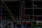
00z HRRR chose violence for parts of Texas and Oklahoma tomorrow night.

Last edited:
Follow along with the video below to see how to install our site as a web app on your home screen.
Note: This feature may not be available in some browsers.
Saw that.00z HRRR chose violence for parts of Texas and Oklahoma tomorrow night.


I still think the WF in OK is the play today rather than the caprock TP. If I was chasing I'd set up in SW OK and keep both in play though. The best tornado params are probably going to be with any supercell that can ride the WF.
Don't trust the HRRR. I think it's underdoing just how messy the TP is going to be near that cutoff low, and the HRRR is notoriously bad with WF initiation (all the CAMs are for that matter).
The HRRR doesn't always do bad with WFs, occasionally it picks them up. That being said, more often than not, I don't trust the CAMs to handle warm fronts well. Forcing mechanisms often cause inaccuracies with mode and it struggles to pick up cells latching onto the front in my experience. From what I'm hearing, the SPC has also said to ignore the CAMs today.HRRR nailed that WF riding Iowa supercell on 4/12. Had it to some degree on every run from the first 48-hour one to come in range. I was not paying as close attention to it at the time, but I do believe it missed the Rochelle, IL tornadic supercell of 4/9/2015 (at least its magnitude, it may have showed a storm but not a simulated echo/UH streak implying violent tornado production).
I thought the HRRR and its apparent ability to resolve individual tornadic supercells was really intriguing when I first found out about it, but its massive overblowing of 5/20/19 even just a few hours ahead of event time kind of soured me on it.

...THERE IS A MODERATE RISK OF SEVERE THUNDERSTORMS FOR PARTS OF
NORTHWEST TEXAS AND THE SOUTHEAST TEXAS PANHANDLE...SOUTHWEST
OKLAHOMA...
...SUMMARY...
Numerous severe thunderstorms are expected across parts of the
southern Great Plains this afternoon through tonight. A few strong
tornadoes and giant hail is most probable across the southeast Texas
Panhandle into portions of southwest Oklahoma and north Texas.
...Southern Great Plains...
Complicated forecast today/tonight as a broad/destabilizing warm
sector enlarges as a warm front advances northward today.
Considerable forecast uncertainty remains evident for a multitude of
possible scenarios, some of which differ both spatially in terms of
severe hazard and intensity. Nonetheless, with the lack of morning
convection across northwest TX into the TX Panhandle, thinking is
this area will remain void of convection through the midday/early
afternoon. Consequently, it seems a categorical Moderate Risk is
warranted for dryline/triple point storms.
Visible-satellite imagery late this morning shows a cirrus canopy
across much of the outlook area. A warm front is rapidly moving
northward across north TX with upper 60s F dewpoints reaching the
Red River as of 16z. A destabilizing boundary layer beneath a
capping inversion, which seems likely to hold through the early
afternoon, will become quite unstable by peak heating with 3000-4000
J/kg MLCAPE forecast over northwest TX by 4pm. The RAP/HRRR seems
to have the best handle on morning storm activity compared to the
ARW and associated CAM models. In general, model guidance indicates
storms will develop over the TX Panhandle during the mid-late
afternoon with more widely spaced thunderstorms farther south along
the dryline. Very steep 700-500 mb lapse rates, enlarged low-level
hodographs via easterly component to low-level flow, and long
hodographs all suggest discrete supercells will be the preferred
mode over the TX Panhandle into northwest TX late this afternoon.
Very large to giant hail (potentially 3+ inches in diameter) and a
few strong tornadoes are possible during the late afternoon into the
early evening as this activity moves into parts of western OK/far
western north TX. Less certain but a plausible scenario involves
free warm sector development farther east across parts of OK and
perhaps north TX. A potentially significant tornado risk could
develop if discrete supercells were to develop within an
increasingly moist/strongly sheared environment during the late
afternoon/early evening.
By early to mid evening, the strengthening of a southerly LLJ and
coalescing of storms/outflow will probably lead to the development
of a severe MCS moving east across parts of OK. Severe gusts,
possibly greater than 65 kt, and tornadoes will become the primary
severe hazards with time. As this activity approaches the western
part of the Ozarks, a lessening in the severe risk is anticipated
late overnight.
...Southeast VA and the Carolinas...
Not much change from the previous forecast in the overall
thunderstorm scenario for VA/Carolinas. A low-amplitude shortwave
trough over the Lower Great Lakes will move east into southern New
England this evening. To the south of this wave, a cold front will
push southeast across the Lower Mid-Atlantic into the Carolinas.
Convergence along the cold front and coastal sea breezes should
support scattered thunderstorms this afternoon. While deep-layer
shear will be modest, it should be adequate for multicells capable
of isolated severe hail and damaging winds. Convection should
largely shift offshore and/or weaken after dusk.

Hopefully, it would be nice to see some large, photogenic tornadoes that don’t impact any habited areas.probably a few field based wedges