
Navigation
Install the app
How to install the app on iOS
Follow along with the video below to see how to install our site as a web app on your home screen.
Note: This feature may not be available in some browsers.
More options
-
Welcome to TalkWeather! We see you lurking around TalkWeather! Take the extra step and join us today to view attachments, see less ads and maybe even join the discussion. CLICK TO JOIN TALKWEATHER
You are using an out of date browser. It may not display this or other websites correctly.
You should upgrade or use an alternative browser.
You should upgrade or use an alternative browser.
Severe WX March 29-30, 2022 Severe Event
- Thread starter DetectiveWX
- Start date
Equus
Member
I feel like both the wind and tornado probabilities are going to verify exceptionally easily with the QLCS alone if even half the warned circulations in the line are putting things down, a high impact day for sure
bwalk
Member
Mercy!

warneagle
Member
It might also get people to take the severe thunderstorm warnings as seriously as they should, since we're talking about straight line winds equivalent to weak tornadoes.I don't fault offices on days like today doing something similar to what JAN did the other day and just go with blanket tornado warnings, especially in radar holes. That line the other day was spitting out small tornadoes left and right as it approached Jackson, but you only see those right up near the radar.
CheeselandSkies
Member
CheeselandSkies
Member
I've always kinda wondered why the radar coverage is so relatively good in western Louisiana with KLCH, KPOE and KSHV all on a staggered north-south line; but so bad along the lower Mississippi River Valley in the areas roughly equidistant between POE/LIX, POE/DGX, LZK/DGX, or LZK/NQA.
MattPetrulli
Member
Imo the best area for short term tornado potential is the area around KPOE/Alexandria. Clearer air and inflow for this area for the time beingYep, I come home from work and the entire d*** line in LA is tornado-warned. Very suspicious area here southwest of Slagle and close to the POE radar site. Could be a one-pixel couplet (almost certainly a tornado) at below 700 feet.
Equus
Member
Unfortunately the research radar at Monroe has been down for a couple weeks now, would have come in handy today
brianc33710
Member
New Tornado Watch, north of the previous one. 90/60 tornado probs.
Good! 80 mph is a good bit higher than most Tor Watches. But they stayed short of PDS probs again.
brianc33710
Member
These should trigger EMAs today given "destructive" severe storms get tornado treatment.It might also get people to take the severe thunderstorm warnings as seriously as they should, since we're talking about straight line winds equivalent to weak tornadoes.
brianc33710
Member
Dewpoints in SC are in the low 60s already. Cen AL for now is in a dry slot of sorts.
BayouWeatherGeek
Member
esoscale Discussion 0356
NWS Storm Prediction Center Norman OK
1247 PM CDT Wed Mar 30 2022
Areas affected...Parts of southwestern through northeastern
Louisiana into northwestern Mississippi
Concerning...Tornado Watch 76...77...
Valid 301747Z - 301845Z
The severe weather threat for Tornado Watch 76, 77 continues.
SUMMARY...Severe thunderstorms posing increasing risk to produce
tornadoes and/or strong, damaging wind gusts through 2-4 PM CDT.
This may including increasing potential for a strong tornado or two
by late afternoon.
DISCUSSION...Surface dew point increases through the mid 60s has now
contributed to moderate mixed-layer CAPE of 1500+ J/kg along a
narrow corridor of stronger 2 hourly (as of 17Z) surface pressure
falls, from near Fort Polk LA into the Greenville MS area.
Southerly flow around the 850 mb layer is forecast to continue to
increase up to around 70 kt along and east of the this axis through
19-21Z, contributing to further enlargement of already sizable
clockwise curved low-level hodographs. With this coinciding with
the sustained strong, and gradually intensifying, thunderstorm
development, supercell structures with strong low-level mesocyclones
will continue to evolve and pose increasing risk for tornadoes
and/or localized strong damaging wind gusts.
..Kerr.. 03/30/2022
...Please see www.spc.noaa.gov for graphic product...
ATTN...WFO...JAN...LIX...LZK...LCH...SHV...
LAT...LON 33969075 33359023 32479053 31239159 30529212 29979313
30399328 31779233 32669207 33969075
kcyalater
Member
the wind is absolutely
i wonder if this will help mitigate things a bit.Dewpoints in SC are in the low 60s already. Cen AL for now is in a dry slot of sorts.
Equus
Member
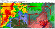
To add to today's issues, major fire weather problems in eastern TN; wildfire getting out of control in Wears Valley just outside Pigeon Forge is triggering local evacuations already

To add to today's issues, major fire weather problems in eastern TN; wildfire getting out of control in Wears Valley just outside Pigeon Forge is triggering local evacuations already
View attachment 12971
Ryan Hall's mentioning that on his stream:
TileDude
Member
I’m north of Birmingham and I’m at 81/58 and dp is slowly rising. Wind gust to 30 so far.the wind is absolutely
i wonder if this will help mitigate things a bit.
Td atop Red Mountain approaching 60