• Welcome to TalkWeather!
    We see you lurking around TalkWeather! Take the extra step and join us today to view attachments, see less ads and maybe even join the discussion.
    CLICK TO JOIN TALKWEATHER

Severe WX December 31, 2021 - January 1, 2022 Severe Threat

Tennie

Member
Messages
935
Reaction score
762
Location
Tennessee
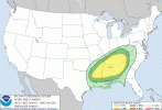
Interesting how the models seem to have been flip-flopping almost to the 11th hour on whether this or today's would be the more significant threat (although that's not uncommon). I've also been following the discussion on the upper Midwest winter storm potential associated with this weekend's system over on the American WX forum, and it appears the potential ceiling of the two types of weather increases/decreases in tandem as the models trend one way or the other vs. the last set of runs.

It seems that certain setups in general tend to be rather hard for models to get a handle on. The 5/3/1999 tornado outbreak was particularly notorious for the issues it posed for the weather models that were in use at the time (the SPC only upgraded their convective outlook to a HIGH only a couple hours or so before the first tornadoes formed), and hindcast experiments done with more recently-developed models have also shown a tendency to produce radically different results with each run--which goes to show just how challenging certain setups (particularly the more subtle ones where even a slight change in a particular parameter can greatly change how the events in question might play out) can be to predict.
 

akt1985

Member
Messages
1,009
Reaction score
509
Location
Madison, Alabama
I wonder if Nashville’s New Year’s Eve celebration will have to be cancelled Friday night due to the risk of severe storms? That event is scheduled to be televised nationally on CBS.
 

Clancy

Member
Messages
2,298
Reaction score
3,971
Location
Macland, Georgia
SPC's D3 Outlook for Saturday. Mentions possibility of substantial severe weather but high uncertainty and several limiting factors.
 

Attachments

  • day3otlk_0830.gif
    day3otlk_0830.gif
    26.2 KB · Views: 0
Messages
491
Reaction score
405
Location
Northern Europe
SPC's D3 Outlook for Saturday. Mentions possibility of substantial severe weather but high uncertainty and several limiting factors.
the flow still remains mostly south-southwest across the warm sector which results in less low-level turning in the lowest 1 km of the hodograph than would be expected for a greater tornado threat...boundary-parallel surface flow will also be less favorable for discrete supercell development within the warm sector...storm mode may remain quite messy...Questions regarding destabilization north of the Tennessee border with Alabama and Mississippi
 

Austin Dawg

Member
Sustaining Member
Messages
852
Reaction score
1,299
Location
Leander, Texas
Looking at the 12z runs, there is enough low level backing for concern, esp in North/central Miss and Al, southern Tenn. I wouldn't be surprised if the track of the low winds up being a little slower and we see other models show more low level backing.
What you said is pretty much what I read everywhere else this morning. 80 kt sheer available, larger warm zone, maybe neg tilted maybe not, Looks like there's a lot of factors that are still uncertain right now... let's hope it's a bust with flurries on the back end.
 

Fred Gossage

Member
Meteorologist
PerryW Project Supporter
Messages
596
Reaction score
2,095
Location
Florence, AL
The main limiting factor, at least for a large part of the day, will be warm mid-level temps... both at 500mb and from the EML-related cap roughly around 700mb. We have steep mid-level lapse rates early in the day because that cap is really strong. It's so strong that forecast soundings have shown that even warming into the upper 70s to near 80 isn't enough to break it! It will take large scale ascent lifting that capping layer, cooling it, and weakening it in order for the cap to break. The problem with that is, as you cool that layer, you decrease the temperature drop between 700mb and 500mb. Your lapse rates aren't as steep and the instability isn't as high because of that. That makes me believe much of the day may underperform, and it may lull people into a false sense of security, especially with the surface low moving off to the northeast by sunset. However, late in the day, the prefrontal trough/front approaches from the northwest. Pressure falls ahead of it keep the low-level flow backed and keep the 850mb jet strong and not as veered. As that happens, large scale ascent has weakened or broken the cap, dewpoints are surging back into the upper 60s toward sunset, heights are falling as the dynamics move in... and in the middle of all that, 500mb temperatures start dropping as that lead impulse moves north and the second mid-level impulse noses in from the west. We suddenly start getting significant instability (maybe even CAPE over 1000-1200) and mid/upper 60 dewpoints, juxtaposed with increasing lift and still very strong shear... set up ahead of the prefrontal trough and the convection along it going from sunset into the overnight. This makes me think this may ride along as a sleeper event for much of the day, and then it catch everyone off guard with a few nasty supercells from the eastern half of MS, riding across the northern 2/3 of AL and up into the southern 1/3 or so of middle TN... maybe even over into north GA.

I think there's strong/long-track type potential, but it's not going to be the glaringly obvious heat of the day event when the surface low is in east Missouri and the lead 500mb jet streak is moving by. If we ride relatively quiet most of the day, don't let your guard down as we approach sunset for MS/AL/TN/GA.
 

Richardjacks

Member
Meteorologist
Messages
1,155
Reaction score
1,308
Location
Atop Red Mountain Birmingham, Al
The main limiting factor, at least for a large part of the day, will be warm mid-level temps... both at 500mb and from the EML-related cap roughly around 700mb. We have steep mid-level lapse rates early in the day because that cap is really strong. It's so strong that forecast soundings have shown that even warming into the upper 70s to near 80 isn't enough to break it! It will take large scale ascent lifting that capping layer, cooling it, and weakening it in order for the cap to break. The problem with that is, as you cool that layer, you decrease the temperature drop between 700mb and 500mb. Your lapse rates aren't as steep and the instability isn't as high because of that. That makes me believe much of the day may underperform, and it may lull people into a false sense of security, especially with the surface low moving off to the northeast by sunset. However, late in the day, the prefrontal trough/front approaches from the northwest. Pressure falls ahead of it keep the low-level flow backed and keep the 850mb jet strong and not as veered. As that happens, large scale ascent has weakened or broken the cap, dewpoints are surging back into the upper 60s toward sunset, heights are falling as the dynamics move in... and in the middle of all that, 500mb temperatures start dropping as that lead impulse moves north and the second mid-level impulse noses in from the west. We suddenly start getting significant instability (maybe even CAPE over 1000-1200) and mid/upper 60 dewpoints, juxtaposed with increasing lift and still very strong shear... set up ahead of the prefrontal trough and the convection along it going from sunset into the overnight. This makes me think this may ride along as a sleeper event for much of the day, and then it catch everyone off guard with a few nasty supercells from the eastern half of MS, riding across the northern 2/3 of AL and up into the southern 1/3 or so of middle TN... maybe even over into north GA.

I think there's strong/long-track type potential, but it's not going to be the glaringly obvious heat of the day event when the surface low is in east Missouri and the lead 500mb jet streak is moving by. If we ride relatively quiet most of the day, don't let your guard down as we approach sunset for MS/AL/TN/GA.
Fred, you description reminds me of a lot of cool season tornado events. Even the marginal ones where tds max out around 63 or 64 just ahead of the trough, and where there is "skinny" cape on the sounding...but in this case the low level are not your typical setup for cool season events...much higher quality moisture is in place...that mixed with the overall upper pattern has me concerned. There is a lot of talk about lack of low level turning, that's not a concern for me...but exactly how it evolves and the mesofield during initiation could make this a sleeper, but I fear it will be something significant....and it may start just about on top of Alabama.
 

Clancy

Member
Messages
2,298
Reaction score
3,971
Location
Macland, Georgia
The main limiting factor, at least for a large part of the day, will be warm mid-level temps... both at 500mb and from the EML-related cap roughly around 700mb. We have steep mid-level lapse rates early in the day because that cap is really strong. It's so strong that forecast soundings have shown that even warming into the upper 70s to near 80 isn't enough to break it! It will take large scale ascent lifting that capping layer, cooling it, and weakening it in order for the cap to break. The problem with that is, as you cool that layer, you decrease the temperature drop between 700mb and 500mb. Your lapse rates aren't as steep and the instability isn't as high because of that. That makes me believe much of the day may underperform, and it may lull people into a false sense of security, especially with the surface low moving off to the northeast by sunset. However, late in the day, the prefrontal trough/front approaches from the northwest. Pressure falls ahead of it keep the low-level flow backed and keep the 850mb jet strong and not as veered. As that happens, large scale ascent has weakened or broken the cap, dewpoints are surging back into the upper 60s toward sunset, heights are falling as the dynamics move in... and in the middle of all that, 500mb temperatures start dropping as that lead impulse moves north and the second mid-level impulse noses in from the west. We suddenly start getting significant instability (maybe even CAPE over 1000-1200) and mid/upper 60 dewpoints, juxtaposed with increasing lift and still very strong shear... set up ahead of the prefrontal trough and the convection along it going from sunset into the overnight. This makes me think this may ride along as a sleeper event for much of the day, and then it catch everyone off guard with a few nasty supercells from the eastern half of MS, riding across the northern 2/3 of AL and up into the southern 1/3 or so of middle TN... maybe even over into north GA.

I think there's strong/long-track type potential, but it's not going to be the glaringly obvious heat of the day event when the surface low is in east Missouri and the lead 500mb jet streak is moving by. If we ride relatively quiet most of the day, don't let your guard down as we approach sunset for MS/AL/TN/GA.
Well, the South sure is no stranger to nighttime events and we've definitely seen plenty of examples where the main day seems like a non-event and the night comes back to bite us.
 

MichelleH

Moderator
Moderator
Messages
861
Reaction score
1,181
Location
Cullman, AL
Well, the South sure is no stranger to nighttime events and we've definitely seen plenty of examples where the main day seems like a non-event and the night comes back to bite us.

April 8, 1998 was a sunny day with blue skies and white, puffy clouds. People thought I was crazy telling them to keep an eye on the weather that night.
 

brianc33710

Member
Messages
346
Reaction score
205
Location
Central Alabama
Special Affiliations
  1. SKYWARN® Volunteer
April 8, 1998 was a sunny day with blue skies and white, puffy clouds. People thought I was crazy telling them to keep an eye on the weather that night.
After the early morning convection cleared out 27 April 2011 was also beautiful. But for the same reasons the warm & wonderful sunshine during those days brought death & destruction both nights. I'm thinking how Gov Bentley mentioned how things had "cleared up & out" nicely by around noon. It took the EMAs explanation to understand why that wasn't a "good" thing, though many were already on alert days ahead.
 
Last edited:

Clancy

Member
Messages
2,298
Reaction score
3,971
Location
Macland, Georgia
Like Fred had mentioned, the SPC makes note in their D2 discussion that the tornado threat may be highest during the evening into overnight, as wind dynamics increase.

Most guidance hints at the potential for some warm sector supercell
development across portions of Mississippi, Alabama, and Tennessee
Saturday afternoon/evening. The ECMWF has been especially bullish
with pre-frontal convection for the last several days, which
continues through the latest 00Z run. Any strong supercells which
can develop in the open warm sector will likely have the greatest
threat for significant to potentially intense tornadoes. The most
likely region for pre-frontal supercell development will be from
eastern Arkansas to northern Alabama and possibly southern Tennessee
where greater instability is forecast. Veered low-level flow will
keep low-level directional shear limited during the first half of
the day. However, at least slightly greater low-level turning is
shown by forecast soundings during the late afternoon into the
evening hours as surface flow remains south-southwest, while the
low-level jet starts to veer more westerly as the main wave shifts
east. This may result in a slightly higher tornado threat into the
overnight hours from far eastern Mississippi into northern/central
Alabama and northwest Georgia.
 
Logo 468x120
Back
Top