
Navigation
Install the app
How to install the app on iOS
Follow along with the video below to see how to install our site as a web app on your home screen.
Note: This feature may not be available in some browsers.
More options
-
Welcome to TalkWeather! We see you lurking around TalkWeather! Take the extra step and join us today to view attachments, see less ads and maybe even join the discussion. CLICK TO JOIN TALKWEATHER
You are using an out of date browser. It may not display this or other websites correctly.
You should upgrade or use an alternative browser.
You should upgrade or use an alternative browser.
Severe WX December 31, 2021 - January 1, 2022 Severe Threat
- Thread starter KevinH
- Start date
That looks quite cellular for being within a marginal risk. HRRR also shows some elevated STP values this afternoon.I am beginning to think there may some issues along the warm front as it moves northward this afternoon

generally HEL is less than 300, but cape could be around 1500That looks quite cellular for being within a marginal risk. HRRR also shows some elevated STP values this afternoon.
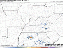
View attachment 11364
bwalk
Member
R. Timmer's take on this setup.
HRRR shows a squall line with major renegade supercell potential in a dangerous environment out in front on afternoon of January 1. Tornado environment will advance east and a little northeast through overnight. Unfortunately target area is same areas impacted by Dec 10 outbreak

HRRR shows a squall line with major renegade supercell potential in a dangerous environment out in front on afternoon of January 1. Tornado environment will advance east and a little northeast through overnight. Unfortunately target area is same areas impacted by Dec 10 outbreak
In looking at everything, I am not sure that is the target area....as the low level jet may not ramp up as much there.R. Timmer's take on this setup.
HRRR shows a squall line with major renegade supercell potential in a dangerous environment out in front on afternoon of January 1. Tornado environment will advance east and a little northeast through overnight. Unfortunately target area is same areas impacted by Dec 10 outbreak
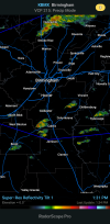
View attachment 11365
Midday update to D2 outlook moves tornado threat northward. SIGTOR risk area remains the same.


...MS/AL/Western and Middle TN...
A more conditional but concerning environment will be in place
across parts of the TN Valley and Mid South on New Years Day. As
the upper trough to the west approaches, very strong low-level winds
and vertical wind shear is expected to become established over this
region, with forecast soundings showing large curving hodographs and
effective SRH values over 300 m2/s2. Surface dewpoints near 70F
will yield afternoon MLCAPE values around 1000 J/kg and a very
favorable conditional environment for supercell tornadoes. However,
a consensus of model guidance is also quite insistent that a warm
nose around 700-800mb will be maintained through much of the day.
This will limit the number of storms that form, and may limit the
updraft strength of those that do. Virtually all 12z CAM guidance
show weak UH tracks despite a few storms forming. Given these
trends, will maintain the ongoing ENH risk area. However, there is
acknowledgment of the risk of a higher end event including strong
tornadoes if later guidance shows a weaker mid-level warm nose and
more robust discrete convective development over the warm sector.
Bama Ravens
Member
Timer is talking up a potential for a few tornado issues in west MS and central AL TODAY. The Hrrr shows a few storms developing, and he thinks parameters may be sufficient for isolated tornadoes.
- Moderator
- #48
Timer is talking up a potential for a few tornado issues in west MS and central AL TODAY. The Hrrr shows a few storms developing, and he thinks parameters may be sufficient for isolated tornadoes.
Great...
Bama Ravens
Member
Of course, Timmer can hype things sometimes. *knock on wood*Great...
- Moderator
- #50
HRRR remains consistent on growth with activity currently seen on radar over central Alabama and now has updraft helicity streaks. Mesoanalysis indicates environment favorable for tornadoes.
SCP put out an MD regarding East-Central Alabama/West-Central Georgia's severe potential today.
PROBABILITY OF WATCH ISSUANCE...20 PERCENT
SUMMARY...SOME INCREASE IN POTENTIAL FOR A COUPLE OF SEVERE STORMS
APPEARS TO BE UNDERWAY, THOUGH STILL A CONDITIONAL/UNCERTAIN
SCENARIO. WW REMAINS UNLIKELY AT THIS POINT, BUT EVOLVING TRENDS
WARRANT CONTINUED EXAMINATION.
DISCUSSION...LATEST VISIBLE SATELLITE IMAGERY SHOWS A SUBTLE
INCREASE IN CONVECTIVE ACTIVITY ACROSS PARTS OF NORTH-CENTRAL
ALABAMA AT THIS TIME. THOUGH RADAR REFLECTIVITY REMAINS WEAK,
LIGHTNING HAS NOW BEEN OBSERVED, AND THIS MUTED CONVECTIVE INCREASE
ALIGNS AREALLY AND TEMPORALLY WITH PERSISTENT DEPICTION IN
SUCCESSIVE HRRR RUNS OF EVENTUAL, ISOLATED SUPERCELL DEVELOPMENT
LATER THIS AFTERNOON. HOWEVER, THE HRRR IS A BIT OF AN OUTLIER IN
TERMS OF COVERAGE/INTENSITY OF AFTERNOON CONVECTION, WITH ONLY THE
HI-RES ARW WINDOW EVEN REMOTELY SUPPORTIVE OF THE PLAUSIBILITY OF
THE HRRR SCENARIO.
FROM A SYNOPTIC PERSPECTIVE, WEAK WARM ADVECTION IS ONGOING, NEAR
AND NORTH OF A SOMEWHAT WASHED-OUT WARM FRONT LYING ACROSS NORTHERN
ALABAMA, WHICH IS SUPPORTING ONGOING/WEAK SHOWERS ACROSS THE
SOUTHERN APPALACHIANS. BACKGROUND SHORT-WAVE RIDGING IS APPARENT,
WHICH SEEMS LIKELY TO HINDER -- OR AT LEAST TEMPER -- POTENTIAL FOR
ROBUST AFTERNOON STORMS.
WITH THAT SAID, DEEP-LAYER FLOW -- THOUGH A BIT VEERED IN THE
BOUNDARY LAYER AND FAIRLY UNIDIRECTIONAL WITH HEIGHT -- IS
CONTRIBUTING TO 0-6KM SHEAR SUPPORTIVE OF UPDRAFT ROTATION. AS
SUCH, DESPITE A LARGER-SCALE PATTERN THAT IS SOMEWHAT INHIBITIVE, WE
WILL CONTINUE TO MONITOR CONVECTIVE EVOLUTION FOR SIGNS THAT THE
MORE AGGRESSIVE HRRR SCENARIO COULD COME TO FRUITION -- WHICH WOULD
HEIGHTEN PROSPECTS FOR WW CONSIDERATION.
tennessee storm chaser
Member
- Messages
- 1,877
- Reaction score
- 4,288
- Location
- jackson tennessee
- Special Affiliations
- SKYWARN® Volunteer
That goes show you what kind atmosphere we are going be dealing with late tomorrow…Crazy to see anything that pops up tries to hook
bwalk
Member
Hmmm,
Is there a notch of weak rotation on that cell west of West Blocton? Not sure but velocity scan indicates possibly a little something trying to stir..

Is there a notch of weak rotation on that cell west of West Blocton? Not sure but velocity scan indicates possibly a little something trying to stir..
I believe so....in the area the HRRR showed for several runs.Hmmm,
Is there a notch of weak rotation on that cell west of West Blocton? Not sure but velocity scan indicates possibly a little something trying to stir..
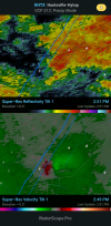
View attachment 11369
brianc33710
Member
I see us under an Enhanced Risk but CBS 42 doesn't rate this event that high on their scales. Maybe the risk increased after their noon news. I guess we will wait & watch to see if the SPC adds a Moderate Risk though that might happen in the areas NW of Bham. Based on their discussion I think that they want to see if an area of convection preceding the worst weather would make things "messy" before the strongest dynamics arrive & it appears this messiness would be more of an issue in MS & AL. Even at its worst case scenario we probably won't see any High Risks issued though.
Austin Dawg
Member

You have more confidence in there not being high risk than I. You are probably right, but it looks like to me the cap may be just strong enough to keep messy conv down but stronger updrafts can overcome...delicate balance.I see us under an Enhanced Risk but CBS 42 doesn't rate this event that high on their scales. Maybe the risk increased after their noon news. I guess we will wait & watch to see if the SPC adds a Moderate Risk though that might happen in the areas NW of Bham. Based on their discussion I think that they want to see if an area of convection preceding the worst weather would make things "messy" before the strongest dynamics arrive & it appears this messiness would be more of an issue in MS & AL. Even at its worst case scenario we probably won't see any High Risks issued though.
bwalk
Member
I'm surprised this is not warned.