I found some photos from the area of northeastern Walker County, where Cordova appears to have hit peak intensity. In this area it completely leveled a site-built home and obliterated two nearby mobile homes. One of the mobile home undercarriages was tossed at least 500 yards. A 5-ton bulldozer was flipped over, a pickup truck was tossed 200 yards, and a dump truck was tossed 50 yards and destroyed. A two-ton trailer was thrown 1 mile and left a 2.5-foot deep crater where it impacted the ground. Two double-wide mobile homes were tossed at least 100 yards, and a third mobile home was tossed 100 yards up a 50 foot embankment and destroyed along this segment of the path as well. I wish I could find more photographs of these impressive feats of damage. I think they used to be available on the old NWS page of this, but after they moved their site it seems they lost lots of 4/27/11 damage survey photographs. So frustratring.
Some of the few photographs available from this area of the path.
Presumably the 5-ton bulldozer that was flipped over, not sure it was placed right side up before the survey or what, not entirely sure what happened here.

Not quite sure what I'm looking at here, ground scouring, a site where a mobile home used to be? There does appear to be tree damage and possible grass or soil scouring in the background, again not entirely sure.

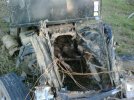
Some sort of vehicle damage. Looks like the dump truck mentioned in the survey that was thrown and destroyed, looks like it's cab was torn off or something to that effect.

Only for sure photograph I've been able to find of the 2-ton utility trailer and its "impact crater" (perhaps just a deep indenture in the soil? Again, not sure). It looks like it was removed from the soil and being propped up by the damage surveyors, really wish I could find a better photograph than this one, which appears to be a hastily-taken cell phone picture.

Link:
https://www.weather.gov/bmx/event_04272011gis
Scroll down to the section entitled
Interactive Map - Tornado Paths and Survey Points


