tennessee storm chaser
Member
My town Jackson tennessee we had a ef4 that day... May 4 2003Both those analogs are from 5/4/2003...MKC is Kansas City which had two F4s and several weaker but still significant tornadoes pass nearby on that day.
Hate to cry wolf again on this one. Seems like we are at the northern edge of the enhanced here in Huntsville, like we were last week. All we got was rain.
Completely different set up. But I do think there will be a large complex of storms that will modulate the northern extent. Where does that set up? I don’t think we have an idea of that now. An evolution like Easter 2020 is possible but maybe shifted NW a bit.Hate to cry wolf again on this one. Seems like we are at the northern edge of the enhanced here in Huntsville, like we were last week. All we got was rain.
Yeah I could see a scenario where the convection lingers around and the best parameters are confined south of I-20 for most of the day. Obviously still a lot of disagreement between the models on the exact northern extent of the threat and we won't really know until the morning of. Easter 2020 could end up being an apt analogy.Completely different set up. But I do think there will be a large complex of storms that will modulate the northern extent. Where does that set up? I don’t think we have an idea of that now. An evolution like Easter 2020 is possible but maybe shifted NW a bit.
The GFS is the most truncated with its warm sector out of all the models, is suffering from convective feedback that Helen Keller could see, and it still gets the warm sector north of the AL/TN line. Some of you guys are in for a surprise...Yeah I could see a scenario where the convection lingers around and the best parameters are confined south of I-20 for most of the day. Obviously still a lot of disagreement between the models on the exact northern extent of the threat and we won't really know until the morning of. Easter 2020 could end up being an apt analogy.
Yeah...a general rule of thumb from 20 years of experience doing this job is that when there are a lot of storms south of us or it rains a lot in the morning here, we don't get much. We sent out posts on our department pages, did media interviews and ran all equipment through checks and fielded what seemed like hundreds of calls last week and we got no severe, but rather flash flooding. Now, they are saying we could have flooding again.
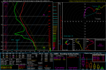
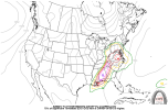
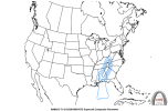
The thing that may hang this up is if the morning storms in MS/AL keep developing on themselves during the day instead of shifting northeastward with time. There's no wedge this time. And there's a 65-70 kt LLJ behind the storms to help promote RAPID air mass recovery if the storms do move out of the way during the day. (Think of how fast the air mass recovered across Alabama behind the morning QLCS on 4/27/11 or how fast the dewpoints rose through central AL on Easter of last year, THAT kind of rapid recovery). We just need to make sure the storms shift northeastward with time instead of sitting there and backbuilding on themselves. They SHOULD move out with time, given the strong wind fields and steeper lapse rates spreading in with time (which is a sign of synoptic scale capping, even if the models at face value don't show a cap on the soundings, think back to last week over LA/MS where the morning cap was stronger than expected on the soundings).
But when that general rule fails, it fails in a horrible way. This isn't like last week. There's no wedge in place, and the low-level jet is literally double the intensity it was over north Alabama last Wednesday afternoon. That makes all the difference in the world.Yeah...a general rule of thumb from 20 years of experience doing this job is that when there are a lot of storms south of us or it rains a lot in the morning here, we don't get much. We sent out posts on our department pages, did media interviews and ran all equipment through checks and fielded what seemed like hundreds of calls last week and we got no severe, but rather flash flooding. Now, they are saying we could have flooding again.
You can bet I'm keeping an eye on it. It was the first thing I checked when I woke up this morning.But when that general rule fails, it fails in a horrible way. This isn't like last week. There's no wedge in place, and the low-level jet is literally double the intensity it was over north Alabama last Wednesday afternoon. That makes all the difference in the world.
Exactly. No big wedge this time, and a much stronger low-level jet the whole day. Air mass recovery will be easier this go around.For those of us in Georgia, don't sleep on this one just because you got rain and rumbles of thunder the last time.
How do you get to these on the CIPS site?For those of us in Georgia, don't sleep on this one just because you got rain and rumbles of thunder the last time.
I'm away from my computer at the moment but when I get back I'll edit this post to add a link.How do you get to these on the CIPS site?