rolltide_130
Member
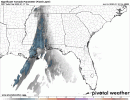
As expected, NAM is already underdoing sfc temps by 4-6 degrees across North AL, and that is with this morning's CURRENT 12z run. Runs 2-3 days ago were underdoing temps here by about 10-15 degrees.
This event is going to be a HARSH lesson for anyone who takes the NAM thermos at face value and wrote it off...
This event is going to be a HARSH lesson for anyone who takes the NAM thermos at face value and wrote it off...