
Navigation
Install the app
How to install the app on iOS
Follow along with the video below to see how to install our site as a web app on your home screen.
Note: This feature may not be available in some browsers.
More options
-
Welcome to TalkWeather! We see you lurking around TalkWeather! Take the extra step and join us today to view attachments, see less ads and maybe even join the discussion. CLICK TO JOIN TALKWEATHER
You are using an out of date browser. It may not display this or other websites correctly.
You should upgrade or use an alternative browser.
You should upgrade or use an alternative browser.
Severe WX Severe Weather Threat 2/6/17-2/8/17
- Thread starter Taylor Campbell
- Start date
-
- Tags
- severe weather
- Thread starter
- Moderator
- #42
This is another confirmed large and extremely dangerous tornado.
CSimonds
Member
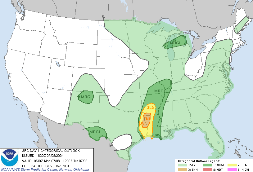
Wow - the SPC has DRASTICALLY changed the Day 1 Outlook.
http://www.spc.noaa.gov/products/outlook/day1otlk.html
stormcentral
Member
At 1119 AM CST, a confirmed large and extremely dangerous tornado was located near East New Orleans, moving east at 20 mph. This is a PARTICULARLY DANGEROUS SITUATION. TAKE COVER NOW! HAZARD...Damaging tornado. SOURCE...Radar confirmed tornado. IMPACT...You are in a life-threatening situation. Flying debris may be deadly to those caught without shelter. Mobile homes will be destroyed. Considerable damage to homes, businesses, and vehicles is likely and complete destruction is possible. Locations impacted include... New Orleans, East New Orleans and Lakefront Airport.
Sent from my LGLS770 using TalkWeather mobile app
Sent from my LGLS770 using TalkWeather mobile app
- Moderator
- #45
Wow - the SPC has DRASTICALLY changed the Day 1 Outlook.
http://www.spc.noaa.gov/products/outlook/day1otlk.html
You became a member!! YAY!!!!
")
Bama Ravens
Member
Storm ENE of New Orleans is likely producing a large tornado.
- Thread starter
- Moderator
- #47
Wow, the area just north of Baton Rouge has been under several tornado warnings today. I think with the one now, that is the third tornado warning for Baker, LA.
Bama Ravens
Member
Storm that is ENE of New Orleans:

Equus
Member
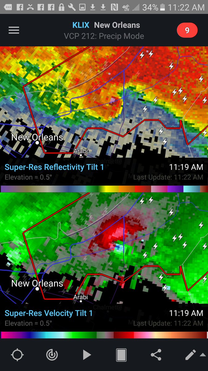
That was a BEAST on radar
- Staff
- #50
GOOD LORD!!!Storm that is ENE of New Orleans:
- Thread starter
- Moderator
- #51
That was a BEAST on radar
I located that debris signature on Google earth. It looks like it hit Michoud and Read Boulevard West. So so so many houses and buildings in that area. I mean so many!
Helicity
Member
stormcentral
Member
Link to my facebook post were a lady recorded tornado in Orleans East.
Sent from my LGLS770 using TalkWeather mobile app
Sent from my LGLS770 using TalkWeather mobile app
- Admin
- #54
- Messages
- 2,403
- Reaction score
- 2,229
- Location
- Meridianville, Al
- Special Affiliations
- SKYWARN® Volunteer
I located that debris signature on Google earth. It looks like it hit Michoud and Read Boulevard West. So so so many houses and buildings in that area. I mean so many!
Hmm. I've worked at Michoud Assembly Facility.
- Staff
- #55
If y'all don't mind, post your pics, videos and damage reports here! It's stickied!
http://www.talkweather.com/index.php?threads/post-pics-and-damage-reports-2-7-17.183/
http://www.talkweather.com/index.php?threads/post-pics-and-damage-reports-2-7-17.183/
Bama Ravens
Member
Video of tornado NE of New Orleans.
Helicity
Member
Live coverage of tornado damage in New Orleans East from WDSU: https://t.co/Z912tP08Ef
- Moderator
- #58
Equus
Member
Suffice to say, I did not expect something like this today!
At least one of the storms west of New Orleans also had an apparent confirmed tornado a bit ago, and I thought I picked up a debris signature briefly. There will be multiple confirmed tornadoes today, and I suspect a couple will have been fairly strong. A little surprising.
At least one of the storms west of New Orleans also had an apparent confirmed tornado a bit ago, and I thought I picked up a debris signature briefly. There will be multiple confirmed tornadoes today, and I suspect a couple will have been fairly strong. A little surprising.
- Staff
- #60
Tornado Warning for Livingston, St. Helena, and Tangipahoa Parish in LA until 12:30pm CST.