• Welcome to TalkWeather!
    We see you lurking around TalkWeather! Take the extra step and join us today to view attachments, see less ads and maybe even join the discussion.
    CLICK TO JOIN TALKWEATHER

Hurricane Isaias

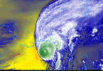
Despite the appearances on satellite/radar, Isaias is still strengthening, Recon shows. Once again, 135-140 mph Flight Level winds recorded in the eastern side of the storm and 120 mph on the west side with pressure in the eye of around 955. Waiting on dropsonde.
 
Lousy timing for the upper and mid levels to moisten up, but that's what's on tap. You can already see the western gulf dry air mixing out on the loop.
1791563905664.png


Isaias will be in range of Eglin NEXRAD soon.
 
Last edited:
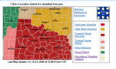
High Wind Warnings for much of North Georgia. Widespread power outages expected. Charging up the flashlights now.

Looks like a very bad time for the western Panhandle and Mobile Bay. Got family there that isn't able to leave.
 
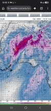
I will say this.......most models have been locked in on the timing for the last 24-48 hours. Everything is consistently between 7pm and 10pm CDT tonight, with most closer to 7pm.
 
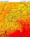
Looking at the hrrr. As the tropical low moves inland the pressure gradient on the northern side of the low gets tighter, along i 20. Their may be a added instigator for more wind damage with tight gradient winds on the northern side when it moves inland.

Maybe a result of the wedge? Eiher way, bad news. Gradient winds and possibly a sting jet in central alabama
 
And a Tropical Storm Warning has been extended northward. It wouldn't surprise me if south central Alabama gets put into a Hurricane Warning category. Geez...this is going to be bad.
 

Attachments

  • 1791565922195.png
    1791565922195.png
    94.9 KB · Views: 33
Back
Top