Throwing this out there. Keep a eye on Saturday and Sunday in the southeast for severe weather
Follow along with the video below to see how to install our site as a web app on your home screen.
Note: This feature may not be available in some browsers.


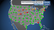

June 11th was in no way a surprise outbreak lmao. It was just HOW those tornadoes happened. People expected your main front to do it but in the end, the confluence bands carried significantly.It seems like most of the surprise tornadoes have been in WI/MI this year. Then there was the surprise June 11th outbreak that happened in Illinois and Indiana. Here's a map of all the suspended and reduced balloon launches. I think they line up pretty well with where these surprise storms have occurred. Any low pressure systems ejecting over the rockies into the northern plains have essentially been entering a blind area. It's possible that a shortwave trough could go completely undetected if timed right. These launches were likely selected for cuts because lower populations around those offices, without any consideration of the downstream effects to forecasting in populated areas.
View attachment 54320
June 11th was in no way a surprise outbreak lmao. It was just HOW those tornadoes happened. People expected your main front to do it but in the end, the confluence bands carried significantly.
Yes, the cuts have significantly made this harder but models are also absolutely dungus this time of year. Combine that with already poor model spread and less balloon launches. Wowza. Models play a very significant part in this too
Ah now, the 21st makes sense. That was a MCV, notorious for surprise sig outbreaks.I might've been thinking of the June 21st outbreak. The one where dozens of tornadoes happened on a slight risk day. Corrected my comment.
In terms of modeling, cutting so many launches around the rocky mountains creates major issues for tracking trough ejections and low pressure systems. It seems all of our surprise systems (and biggest busts) are occurring downstream of this huge blind spot. Instead of being dispersed around the country, these cuts are grouped in one huge region, and it's affecting forecasting in the upper midwest and great lakes.

A
Ah now, the 21st makes sense. That was a MCV, notorious for surprise sig outbreaks.
Oh, i absolutely agree. When systems literally come in from the western side of America, and we don't have modeling data to detect if the trough is stronger or weaker, that will make all our forecasts fall downwards.
Is that based mainly on the Euro? ASTORP has some marginal agreement on both days. Usually, it having marginal 6,days out always means there's a chance for slight eventually onwards.Throwing this out there. Keep a eye on Saturday and Sunday in the southeast for severe weather
I think you kick yourself too hard with chasing. You have to trust your gut a load of the time and you have to bs ready to seize the moment especially with opportunities of close range shots.Yeah, it blows. Even more amazed I was able to catch the southern MN tornado on 4/13 this year yet still more p**sed at myself for not taking full advantage of the opportunity and getting closer when literally all I would have had to do was keep driving 3 more miles up 260th Ave. CAMs have been such hot garbage. Although there have usually been a few runs of the HRRR and or 3KM NAM that have sniffed out something close to what actually happened, but not with the degree of consistency necessary for me to fully buy into it.
I think you kick yourself too hard with chasing. You have to trust your gut a load of the time and you have to bs ready to seize the moment especially with opportunities of close range shots.


I'd say there's still chasing opportunities for Wisconsin this year. Use them as a learning curve and who knowsYeah. That's the part I'm still working on. Now that I've (mostly) moved past abandoning a target that would later produce the storm of the day while en route, in favor of one that Atmospheric Anti-Climax or going home (6/16/14, 4/9/15, 5/26/21). 7/14/21, 8/9/21, 4/12/22 I was on or within easy striking distance of the right storm at the right time but failed to get the shot. It's just frustrating because of how few opportunities I get. 4/14 turned into HP slop in WI and I damaged my car. Sat out 4/17 for that reason plus the fact that I thought it would also be HP slop...which it was, except for the glorious moment the Rockton tornado popped out of the rain, which would have been in easy range for me. Then I was in Ohio on a family vacation for 6/11.
*Edit* Are we really still forcing the use of "Atmospheric Anti-Climax" even outside the context of active events?
Wisconsin tornado took us thereSince nobody's brought it up, we've made it to 100 pages for the 2026 thread!