
Navigation
Install the app
How to install the app on iOS
Follow along with the video below to see how to install our site as a web app on your home screen.
Note: This feature may not be available in some browsers.
More options
-
Welcome to TalkWeather! We see you lurking around TalkWeather! Take the extra step and join us today to view attachments, see less ads and maybe even join the discussion. CLICK TO JOIN TALKWEATHER
You are using an out of date browser. It may not display this or other websites correctly.
You should upgrade or use an alternative browser.
You should upgrade or use an alternative browser.
Severe Weather 4/17/26
- Thread starter N0mz
- Start date
Cyclonic Paracosm
Member
wow site is passing away rn, single images and small sentences are killing it rn
- Thread starter
- #183
N0mz
Member
I’d chalk that more up to the difficulty of recording tornadoes (especially pre-wsr88d) in Dixie vs the relative ease in the Plains. Before 1974 it wasn’t really well known that violent tornadoes happened often in Dixie.There are papers out there purporting to show a long-term eastward shift in the locus of tornado activity. Critique them how you want, but what's going on here is some simply vibing that it can't have happened.
- Moderator
- #184
I need a storm chasing partner that can drive the other half to chase these systems that are 13 hours away.
Last edited by a moderator:
Cyclonic Paracosm
Member
I will say, given how hrrr is the only somewhat simi-discrete model rn I kinda wanna wait for obs data b4 making any decisions. This happens here and there and people forget that I feel like.
Weatherguyx
Member
Cyclonic Paracosm
Member
at first I twas thinking wtf but then I saw the geographic section and it kinda clicked, is that why union center ef3 occured and well 90% of MS based tornadoes?
Is that actually the case or is it a presumption? And the major southern outbreaks in 1908, 20, 32 and 36 are not the best documented, but they were certainly known.I’d chalk that more up to the difficulty of recording tornadoes (especially pre-wsr88d) in Dixie vs the relative ease in the Plains. Before 1974 it wasn’t really well known that violent tornadoes happened often in Dixie.
I'd also add that part of the contention is a decrease in Plains tornadoes. That isn't dependent on what's happening in the SE.
Last edited:
KakashiHatake2000
Member

- Moderator
- #190
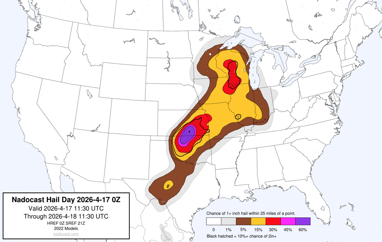
Insane hail probs on Nadocast and CSU MLP.
Kds86z
Member
New day 1, few strong tornadoes bla bla. Nothing special
jiharris0220
Member
That’s not ideal
Ozonelayer
Member
Latest HRRR has several discrete supercells well infront of the coldfront. If the trend continues, a MDT risk is definetly on the table
Aaron Rider
Member
I’d chalk that more up to the difficulty of recording tornadoes (especially pre-wsr88d) in Dixie vs the relative ease in the Plains. Before 1974 it wasn’t really well known that violent tornadoes happened often in Dixie.
The South was also *very* isolated in many ways until well into the 20th century. Remember, until the 1960s, the St. Louis Cardinals were considered the Team of the South because there were no professional sports teams in the actual South, just as an example of how isolated the region was.
Ozonelayer
Member
10z keeps up a similar outcome, although its more akin to a semi-discrete line of supercells ahead of the coldfront than the 09z and its more discrete outcome. Both however would be supportive of a high end tornadic event across Wisconsin.
Ozonelayer
Member
And on that note, the 08z going back to the 06z show similar outcomes to the 09z and 10z HRRR. If this trend continues, I would be on board with a tornado driven MDT for Central/East Central Wisconsin10z keeps up a similar outcome, although its more akin to a semi-discrete line of supercells ahead of the coldfront than the 09z and its more discrete outcome. Both however would be supportive of a high end tornadic event across Wisconsin.
jiharris0220
Member
Doubt they will pull a moderate risk. Every cam would have to consistently show the same outcome, it can happen. But it doesn’t really matter. CIG2 is effectively a moderate risk but low certainty.
Moving on though, looking at the OWS at first light, other than a small area of lake breeze fog, theres not a single cloud deck in the sky.
In this case, it’s best to trust cam models that show the highest surface temps (specifically). The solutions showing temps peaking in the low 70s in Wi are most certainly erroneous at this point.
Expect actual surface temps to peak in the high 70s to even low 80s. This definitely would favor a more organized discrete mode and even higher cape values.
Ozonelayer
Member
The point regarding CIG2 being a low confidence MDT is actually pretty good. I'd actually have to agree now and further on.Doubt they will pull a moderate risk. Every cam would have to consistently show the same outcome, it can happen. But it doesn’t really matter. CIG2 is effectively a moderate risk but low certainty.
Moving on though, looking at the OWS at first light, other than a small area of lake breeze fog, theres not a single cloud deck in the sky.
In this case, it’s best to trust cam models that show the highest surface temps (specifically). The solutions showing temps peaking in the low 70s in Wi are most certainly erroneous at this point.
Expect actual surface temps to peak in the high 70s to even low 80s. This definitely would favor a more organized discrete mode and even higher cape values.
If the lack of cloudcover remains today, then we could be in for a very dangerous day in Wisconsin. A tornado outbreak is most certainly not off of the table today, so keep a good eye out. Kinematics and Thermos will be high today, so don't hesitate as any mature supercell will have the potential for sigtors.
UpperLevelLOL
Member
Oooh interesting post. Also worth remembering that flooding is also still pretty bad in that area from earlier this week, so chasing that area might be even more tricky.