Kory
Member
In other news, GFS and CMC showing tropical cyclongenesis in the W Caribbean and moving north into the Gulf over the course of the next week.
Follow along with the video below to see how to install our site as a web app on your home screen.
Note: This feature may not be available in some browsers.


ZCZC MIATWOAT ALL
TTAA00 KNHC DDHHMM
Tropical Weather Outlook
NWS National Hurricane Center Miami FL
800 PM EDT Wed Jul 4 2018
For the North Atlantic...Caribbean Sea and the Gulf of Mexico:
1. Disorganized showers and thunderstorms located a few hundred miles
to the south and southwest of Bermuda are associated with a weak
trough of low pressure. Environmental conditions appear conducive
for some development of this system, and a tropical depression
could form before the end of the week while the system moves
west-northwestward and then northward between Bermuda and the east
coast of the United States. The disturbance is then forecast to
interact with a frontal system on Sunday, which would limit any
additional development.
* Formation chance through 48 hours...medium...40 percent.
* Formation chance through 5 days...medium...50 percent.
2. Shower activity associated with a small area of low pressure and a
tropical wave located about 1000 miles west-southwest of the
Cabo Verde Islands continues to become better organized. A tropical
depression is likely to form during the next day or two while the
system moves westward to west-northwestward at 15 to 20 mph over the
tropical Atlantic Ocean. By the weekend, however, upper-level winds
are expected to become less conducive for development when the
system approaches the Lesser Antilles.
* Formation chance through 48 hours...high...70 percent.
* Formation chance through 5 days...high...70 percent.

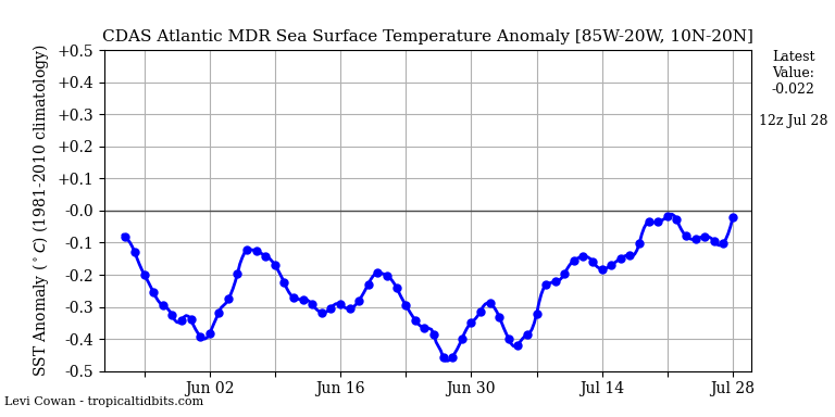
Big Saharan dust layer out over the Atlantic due to a strengthening Bermuda ridge and enhanced trades is permitting more evaporative cooling. The MJO looks to remain unfavorable for at least the next 1-2 weeks.Welp, just when it looked like the SSTs in the Atlantic were recovering and becoming more favorable

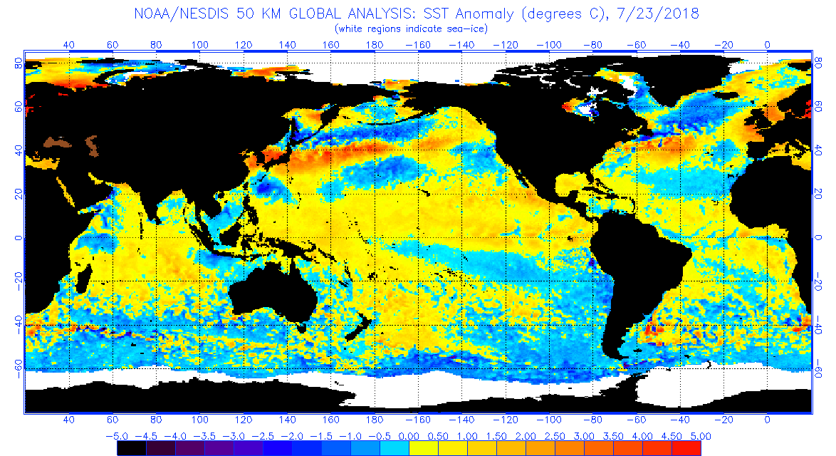


Thought this was intriguing regarding the discrepancies. OPSO (the images I posted) incorporates buoy and ship data. It seems the satellite only derived data is having some issues regarding over-cooling. I don't think the Atlantic is cooling at the rate the satellite data shows...it just isn't warming to climatological levels. With the MJO weakening, I suspect a warming trend in the coming few weeks.Oh absolutely. Cooler SSTs out in the tropical Atlantic don't mean anything once a storm gets into the GOM or in close off the east coast. (or forms in one of those locations)
Also, I wonder why the Atlantic looks so much different on that map you posted than some of the other SST maps? Everything else seems to match up
Thought this was intriguing regarding the discrepancies. OPSO (the images I posted) incorporates buoy and ship data. It seems the satellite only derived data is having some issues regarding over-cooling. I don't think the Atlantic is cooling at the rate the satellite data shows...it just isn't warming to climatological levels. With the MJO weakening, I suspect a warming trend in the coming few weeks.