WeathermanLeprechaun
Member
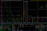
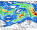
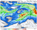
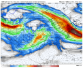
I've actually been using this tool for a bit since i got private access to it but it seems that it has made public so, these are automated GEFS outlooks for severe weather (Europe/US) https://rawinsonde.com/index.html
Follow along with the video below to see how to install our site as a web app on your home screen.
Note: This feature may not be available in some browsers.
Give it a few more days lolThoughts?
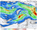
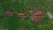
As this system continues east across the ArkLaTex into the Lower MS
Valley on Monday, some severe potential could persist into these
areas. However, uncertainty regarding moisture return and degree of
destabilization due to potentially ongoing and widespread training
precipitation precludes severe probabilities at this time. Some risk
could continue across parts of the TN Valley/Southeast into Tuesday.
However, the upper trough is expected to be weakening and lifting
well north of the region by this time.
Thoughts?
As this system continues east across the ArkLaTex into the Lower MS
Valley on Monday, some severe potential could persist into these
areas. However, uncertainty regarding moisture return and degree of
destabilization due to potentially ongoing and widespread training
precipitation precludes severe probabilities at this time. Some risk
could continue across parts of the TN Valley/Southeast into Tuesday.
However, the upper trough is expected to be weakening and lifting
well north of the region by this time.

Wishing her and your family well!Early next week looks interesting in regards for severe weather. I honestly haven't hardly been keeping up with forecast models or weather in general lately. My grandma had a seizure earlier this week and it's been a whirlwind ever since.
Say what now?Haven't seen not the first report out of this evening from there
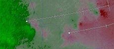
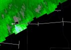
The tweet noted that there was 3 unwarn tornadoes yesterday in Mississippi. There hasn't been the first report of that happening.Say what now?
Early next week looks interesting in regards for severe weather. I honestly haven't hardly been keeping up with forecast models or weather in general lately. My grandma had a seizure earlier this week and it's been a whirlwind ever since.
Chaser in the area was in Laurel, MS and said there was a likely rain-wrapped tornado.Haven't seen not the first report out of this evening from there