Navigation
Install the app
How to install the app on iOS
Follow along with the video below to see how to install our site as a web app on your home screen.
Note: This feature may not be available in some browsers.
More options
-
Welcome to TalkWeather! We see you lurking around TalkWeather! Take the extra step and join us today to view attachments, see less ads and maybe even join the discussion. CLICK TO JOIN TALKWEATHER
You are using an out of date browser. It may not display this or other websites correctly.
You should upgrade or use an alternative browser.
You should upgrade or use an alternative browser.
Hurricane Melissa
- Thread starter Jacob Aden
- Start date
TornadoFan
Member
Hurricane warnings up for Jamaica now.
Cyclonic Paracosm
Member
there is still a
possibility that Melissa could become a category 5 hurricane during
the forecast period. After passing near or over Jamaica,
thats concerning, still holding onto that..... makes sense but still
possibility that Melissa could become a category 5 hurricane during
the forecast period. After passing near or over Jamaica,
thats concerning, still holding onto that..... makes sense but still
tornado examiner
Member
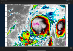
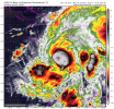
That central blob looks much nicer now. Maybe attempting to stack more vertically again.
- Moderator
- #145
I am thinking a slow drift northwest with the weak steering currents. Could become nearly stationary off the eastern coast of Jamaica as it waits to be pulled north and east. Rapid intensification looks likely and I could see this becoming at Cat 5.

Last edited:
Cyclonic Paracosm
Member
yeah in gen it looks really good, much better over the past few minutes nowThat central blob looks much nicer now. Maybe attempting to stack more vertically again.
Cyclonic Paracosm
Member
I mean NHC still says this could very much happen so we just gotta wait and see atpI am thinking a slow drift northwest with the weak steering currents. Could become nearly stationary off the southeast tip of Jamaica as it waits to be pulled north and east. Rapid intensification looks likely and I could see this becoming at Cat 5.
View attachment 47748
- Moderator
- #148
That central blob looks much nicer now. Maybe attempting to stack more vertically again.
Yes sir, think this is lift off. Should see quite the improvements through the early morning hours.
tornado examiner
Member
We won't know for sure until recon confirms the sheer is no longer tilting it. But based on visuals of IR it looks like that could be the case. In which case, yes it could be go time unless upwelling has occurred. (which is unlikely)Yes sir, think this is lift off. Should see quite the improvements through the early morning hours.
- Moderator
- #150
I don’t see any reason this isn’t on the way to jumping several categories and too major status soon.
tornado examiner
Member
Melissa kinda looks like Oscar did last year. A localized blob of a hurricane spinning really fast with a tiny invisible eye due to cloud cover.
N0mz
Member
How can you tell where LLC is?
tornado examiner
Member
Recon data? That's the only place I know where to find it.How can you tell where LLC is?
tornado examiner
Member
Could it's centered have reformed to the east again? It looks like it might have.
tornado examiner
Member
Saturday here. RI to begin some time today.
Speaking of which, those latest scans are scaring me. New bands forming, and the whole blob just kind got a rotation to it. Bending into a very squat curl. I kinda don't wanna go too sleep just too see what it does in the near term still.
Speaking of which, those latest scans are scaring me. New bands forming, and the whole blob just kind got a rotation to it. Bending into a very squat curl. I kinda don't wanna go too sleep just too see what it does in the near term still.
Last edited:
tornado examiner
Member
Pressure is down to 987MB.
tornado examiner
Member
I have little doubt that Melissa is a hurricane now, even while still fighting sheer.
tornado examiner
Member
Not officially a hurricane yet though. And still won't be til 7am
N0mz
Member
Yep looking better on IRPressure is down to 987MB.
tornado examiner
Member
You can see the curl and swirl on the infrared. It's really trying to fight the dying sheer. This is another “it's gonna blow up soon” kinda look.Yep looking better on IR