Lake Martin EF4
Member
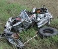
OK, I think this may be the best tornado aftermath photo I've ever seen. It's at bare minimum in the Top 5.View attachment 46522
Just saw this photo from Mayfield 2021 for the first time...
Follow along with the video below to see how to install our site as a web app on your home screen.
Note: This feature may not be available in some browsers.
OK, I think this may be the best tornado aftermath photo I've ever seen. It's at bare minimum in the Top 5.View attachment 46522
Just saw this photo from Mayfield 2021 for the first time...

 www.tempesttours.com
This tornado been discussed?
The Seward, Nebraska, Tornado | Tempest Tours | Weather Expeditions & Vacations
Dean Cosgrove and I caught the tornado near Seward, Nebraska, on Wednesday for the Tempest Tours gang. The tornado was large and slow moving, and we had great contrast and were able to set up camcorders on tripods and watch it from 3-4 miles away!
It's another perfect case of an extremely violent tornado not hitting the right structures at its peak. The farmhouse that was swept away was on a block foundation with minimal or no anchoring.
Thank you @TH2002 and wow didn’t realize this was so violent and powerful tbhIt's another perfect case of an extremely violent tornado not hitting the right structures at its peak. The farmhouse that was swept away was on a block foundation with minimal or no anchoring.
Did it reach F5/EF5 intensity at some point? Almost certainly. But if it didn't get rated F5 back then, there's ZERO chance it would be rated EF5 today.
Most WFO's (especially more liberal ones like DGX and FFC) would probably give this one a 170-180MPH EF4 rating. Which, honestly, would be a perfectly acceptable call. More conservative WFOs like LBB would probably give it 160-165MPH EF3.
(Old message)Made by the same people who gave Jarrell an F3 rating because they missed all the bolted-down houses.

Incredible youtube short I found from the March 31, 2023 tornado outbreak as a violent tornado was impacting Robinson, IL at around 70 mph. You can see just how fast this beast was moving and to this day, I truly feel like it was one of the higher end tornadoes of the day.

Stronger than Smithville? I’d love to hear about these cycloidal measurements suggesting this. I’ve always leaned a bit towards the side that cycloidal measurements seem to overrate intensity. I’ll admit that at first, reading this immediately raised my eyebrow, but that image is very, very violent damage.not just one of the higher end tornadoes of the day, but one of the highest end tornadoes ever. cycloidal measurements indicate it is likely stronger than the likes of smithville. it also had an undocumented cycle, with the 2nd tornado producing some pretty impressive tree damage (seen below, cycloids indicate it was high end EF4 - low end EF5 over these trees.View attachment 46597
You could easily make the argument it was the strongest tornado of that outbreak. I think saying stronger than Smithville may be a bit much in my opinion…Stronger than Smithville? I’d love to hear about these cycloidal measurements suggesting this. I’ve always leaned a bit towards the side that cycloidal measurements seem to overrate intensity. I’ll admit that at first, reading this immediately raised my eyebrow, but that image is very, very violent damage.
I’d also be surprised if it even came close to Smithville in intensity because the environment the supercells near the thermal boundary were located within on 4/27 was as upper echelon as it gets.
Here is the RAP reanalysis proximity sounding of the Robinson tornado. I’ve noticed these reanalysis skew Ts can really undercount thermodynamics and instability, so take those measurements with a grain of salt. However, this tornado took place well after dark so instability was decreasing with time.I’d also be surprised if it even came close to Smithville in intensity because the environment the supercells near the thermal boundary were located within on 4/27 was as upper echelon as it gets.

I think Keota and Sullivan were both capable of maybe producing EF5 damage at some point in their lifetime.Robinson-Sullivan was an extremely impressive tornado and I agree with those who are of the opinion that the survey was pretty bad; this tornado was at least as deserving of EF4 as Keota on that day. Little Rock has the next-highest official wind speed at 165 MPH, but I think Covington and possibly its predecessor Wynne were likely stronger. Keota's predecessor that formed just northeast of Ottumwa, IA was probably at least as intense as those, as well.
By the standards of 1990s F-scale or 2007-5/20/13 EF-scale, you could probably have had 4-5 violent tornadoes with that outbreak.