• Welcome to TalkWeather!
    We see you lurking around TalkWeather! Take the extra step and join us today to view attachments, see less ads and maybe even join the discussion.
    CLICK TO JOIN TALKWEATHER
  • Current Tropical Systems
    Erin

Enhanced Fujita Ratings Debate Thread

I think I know which advertiser is doing it. I've removed them. Let me know if I comes back up again.
Idk I'm still getting it, it's only happening when I try to go to the Significant Tornadoes thread tho lmao
This is like the dumbest place I could think of to try and run scam adverts lol
 
Last edited by a moderator:
[The following is a Public Service Announcement from TH2002]

I use an ad blocker, people. Not just because ads are annoying and often take up 80% of the page you're trying to read, but that Internet ad networks have become so overwhelmed with malvertising that my trust in ALL ads has been completely eroded.

It makes me feel sorry for sites like TalkWeather that genuinely rely on ad revenue, and try to keep annoyance to a minimum (on the other hand, screw websites that tell you to turn off your ad blocker, and then BOOM, there's literally more ads than actual content)

And if you're on a mobile device, you can use the mobile version of Brave. And if you're on an iPhone and insist on using Safari, I think ad blocking extensions exist for it too.
I’ll check out Brave. I use the DuckDuckGo mobile browser vs safari and have it locked down cookie, ads, and tracking wise. So it was a bit weird when I started getting those iPhone virus ads. Could be because I marked the site trusted when I log in, or what ever architecture DuckDuckGo is built on is no better than Chrome or Safari.
 
Idk I'm still getting it, it's only happening when I try to go to the Significant Tornadoes thread tho lmao
This is like the dumbest place I could think of to try and run scam adverts lol
Thanks for posting. Helps me narrow down the offender.
 
Alright we have disabled one ad network. From this point on let me know if you see it again. Please accept my apologies as we we try to get away from Google.
 
Last edited:
Cullman, Alabama EF4 - 04/27/2011
Path Length: 50 miles
Fatalities: 6
Injuries: ~148

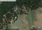
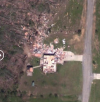
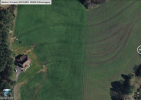
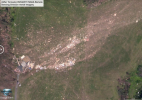
This was an absolute freakshow of a tornado. Subvortices danced in every direction vertically and horizontally. It started extremely thin, with a razor sharp damage gradient. These before and after photos from early in the path are a clear indication of the tight wind fields it had. Notice how two homes were completely wiped away without hardy a trace.
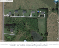
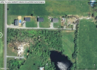
1754961452770.png1754961452563.png

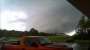
Just before the densely populated area of Southwest Cullman the tornado lifted, but the above ground rotation still looked ominous and foreboding.


Every time subvortices stretched and touched the ground they'd rip off roofs and tear up trees. The beginning of this video shows one such instance


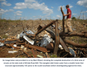
At one point it hit a radio tower with a NOAA Weather Radio Transmitter on the bottom. It ripped apart and mangled the top portion of the tower, but the NOAA transmitter was left undamaged and still transmitting (just with a range of about 30 feet due to having no antenna).

The moment it hit the tower was recorded in this video from 0:27-0:36


It hovered above the ground scraping branches off trees and roofs off houses until it hit a powerline above 5th street SE that cut out power to ABC's skycam and killed James Spann's live feed. At this moment the primary subvortex roared into a pillar of churning destruction. Its color darkened and started hurling debris into the sky at incredible speed.

This transformation can be seen at 2:30 in this video


during this part of the tornado's life it only lingered over any given location for 1 to 2.5 seconds. it spent 5 seconds in a packed city block and demolished 10 out of 15 of the businesses there. "The entire second story of the exceptionally thick, brick-built Cotton States Insurance vanished, with the
first floor a broken shell."
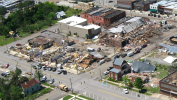
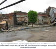
1754970477982.png
1754970234598.png1754970730039.png

"The building exploded and it was over just as fast as it hit. I was under the building-you know with bricks, cinderblocks, everything."

-Kitty Crawford, Busy Bee Cafe

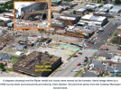
The tornado dashed through an intersection, carrying with it four large and one smaller Ryder rental box trucks. One of the bigger 7 ton vehicles was stripped of its cargo and launched 60 yards. Another, was sent flying into the old Little Bit of Everything store, and was pushed so deeply into the building it couldn't be seen from the outside.

Probably shouldn't be sharing these ones, but they're too crazy not to. Please don't share outside of this site.
1754971488373.png
1754971555602.png

Here's the moment on video (2:04 - 2:12)


This was the story for the first half of the tornado's life. It lifted and caused minimal damage, then crashed down with ferocious intensity. Finally, the condensation funnel fully reached the ground and it became a .85 mile wedge that obliterated everything it touched.

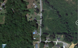
Here's a before and after from county road 1635
1755030765029.png1755030779271.png

And another home from CR 1593

1755030895580.png
^^ Notice the 35-by-7-foot concrete porch broken in two.

continued...
 
Last edited:
Finally, the condensation funnel fully reached the ground and it became a .85 mile wedge that obliterated everything it touched.
That transformation into a wedge had to do with the infamous thermal boundary that Smithville and Hackleburg also took advantage of. I believe by that point the boundary, which was already pretty diffuse in that part of Alabama, had drifted a little northeast of Cullman. Once the tornado left Cullman and crossed into it, the lower LCLs led to a more wedge appearance.

There’s a great academic paper on it, I’ll have to link it when I find it.
What’s crazy is how similar to the Cordova EF4 the tornado looked, yet if you told a Wx enthusiast the Cullman tornado was a wedge there’s a 50/50 chance they’d call you out of your mind. Only the tornado’s initial appearance and first few miles of its path were well-remembered (although zero deaths occurred along this portion of the tornado's path; all six were later down). There’s several good photos and videos of the tornado near Arab, and it seriously makes a run for “scariest tornado presentation of 4/27”, although Hackleburg is clearly the winner there.
1755038741871.png
 
Last edited:
Cullman continued...

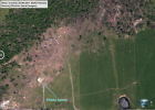
Most of the ground level photos were exclusively shared with Tornado Talk by NWS surveyor Chris Darden. Considering this is a thread where we criticize tornado ratings and sometimes surveyors themselves I'm hesitant to share his photos without permission. Maybe @NickKrasz_Wx can get it! This is why most of the images I share will be satellite photos with descriptions.

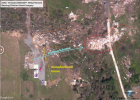
The most intense damage in Morgan county occurred at Beverly and Larry Pirkle's residence. They just finished this "dream home" after 3 years of construction and had only been living in it for 5 weeks. Two family members lived in double wide manufactured homes on the property as well. A change in treefall pattern just as the twister struck the residence showed that the primary subvortex was particularly tight and volatile here. No debris was left behind from any of the three structures aside from three distinct streaks 260-360 yards to the Northeast.

1755033296020.png
1755033296056.png

Here's what the tornado looked like as it passed through the area


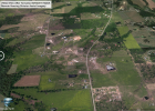
Part two of the tornadoes life occurred in sparsely populated rural area, but every home it hit was completely destroyed, with several having very little debris left behind. The intensity of destruction to wooded areas was worse even than the Little Rock, GA tornado. The tornado crossed into Marshall county traveling at 55 mph, with a diameter of 1,070 yards, but the strongest core of winds was only 55 yards wide. It hit the community of Ruth and destroyed several houses with vicious strength. Heavy farm equipment was tossed up to 20 yards.

1755038221385.png

12 residences were destroyed along the heavily wooded Edmonton and Parkwood Lanes.

1755038663706.png
1755038708668.png

In one .3 mile stretch a subvortex completely removed trees from their original locations, shattering several into small splinters, and flattening and debarking those that remained while caking them with dirt and debris. A 475 yards stretch of typical grass field was gouged several (or more) inches deep.

1755038978570.png
1755038983495.png
1755039116901.png

1755039253574.png

A 1.5 story home further down the path was lofted in one piece, with residents inside, and landed 100 yards away. The residents were swept another 100 yards after that.

1755039749975.png
5 people out of a family of 6 perished. 6-year-old Ari Hallmark was the only survivor.

continued...
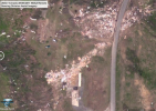
 
"Of the seven residences destroyed on the north side of Frontier Road, the [well built] Johnson home was one of the worst. The large, 1.5-story brick and wood home was razed from its foundation with the debris wind-rowed over 150 yards to the northeast. Some of the gravel from the driveway was pushed into the grassy lawn. Shrubs in front of the home were bent and significantly stripped, a couple of medium to large trees in the front yard were missing, and others in the vicinity were partially debarked."

These are some of the more important images from the tornado, so I'm sharing for discussion purposes.

1755040351744.png
1755040376087.png

Another home (at the top) was also thrown.

1755053592083.png
1755053616373.png

The destruction continued along Ruth road. Homes were destroyed on several properties with widespread debarking of trees. All 21 homes in the Ruth Mobile Home Park was a total loss, one steel undercarriage was tossed 150 yards into the field beyond, and several others were disintegrated. A pickup truck was completely torn in two from its chassis, and launched 475 yards (.27 miles) downwind.

1755054101999.png
1755054291718.png1755054311748.png

three more frame homes were destroyed along fulton road. One was ground apart into tiny bits and dramatically windowed more than 270 yards.

1755054458243.png1755054484173.png

Several other smaller homes were swept away and disintegrated before the tornado finally began to dissipate

New Rating: (E)F5

Reasons: Incredible phenomena, brick home blown away, pickup truck ripped in half and carried 411 meters. Significant...debarking? It was more like atomization.


1755054969363.png
 
"Of the seven residences destroyed on the north side of Frontier Road, the [well built] Johnson home was one of the worst. The large, 1.5-story brick and wood home was razed from its foundation with the debris wind-rowed over 150 yards to the northeast. Some of the gravel from the driveway was pushed into the grassy lawn. Shrubs in front of the home were bent and significantly stripped, a couple of medium to large trees in the front yard were missing, and others in the vicinity were partially debarked."

These are some of the more important images from the tornado, so I'm sharing for discussion purposes.

View attachment 45959
View attachment 45960

Another home (at the top) was also thrown.

View attachment 45966
View attachment 45967

The destruction continued along Ruth road. Homes were destroyed on several properties with widespread debarking of trees. All 21 homes in the Ruth Mobile Home Park was a total loss, one steel undercarriage was tossed 150 yards into the field beyond, and several others were disintegrated. A pickup truck was completely torn in two from its chassis, and launched 475 yards (.27 miles) downwind.

View attachment 45968
View attachment 45969View attachment 45970

three more frame homes were destroyed along fulton road. One was ground apart into tiny bits and dramatically windowed more than 270 yards.

View attachment 45971View attachment 45972

Several other smaller homes were swept away and disintegrated before the tornado finally began to dissipate

New Rating: (E)F5

Reasons: Incredible phenomena, brick home blown away, pickup truck ripped in half and carried 411 meters. Significant...debarking? It was more like atomization.


View attachment 45974
Yeah, I really can't argue with this one. This tornado was DRAMATICALLY more intense than I realized or is commonly known. This actually might be more intense than Tuscaloosa, which i also regard as an F or EF5
 
"Of the seven residences destroyed on the north side of Frontier Road, the [well built] Johnson home was one of the worst. The large, 1.5-story brick and wood home was razed from its foundation with the debris wind-rowed over 150 yards to the northeast. Some of the gravel from the driveway was pushed into the grassy lawn. Shrubs in front of the home were bent and significantly stripped, a couple of medium to large trees in the front yard were missing, and others in the vicinity were partially debarked."

These are some of the more important images from the tornado, so I'm sharing for discussion purposes.

View attachment 45959
View attachment 45960

Another home (at the top) was also thrown.

View attachment 45966
View attachment 45967

The destruction continued along Ruth road. Homes were destroyed on several properties with widespread debarking of trees. All 21 homes in the Ruth Mobile Home Park was a total loss, one steel undercarriage was tossed 150 yards into the field beyond, and several others were disintegrated. A pickup truck was completely torn in two from its chassis, and launched 475 yards (.27 miles) downwind.

View attachment 45968
View attachment 45969View attachment 45970

three more frame homes were destroyed along fulton road. One was ground apart into tiny bits and dramatically windowed more than 270 yards.

View attachment 45971View attachment 45972

Several other smaller homes were swept away and disintegrated before the tornado finally began to dissipate

New Rating: (E)F5

Reasons: Incredible phenomena, brick home blown away, pickup truck ripped in half and carried 411 meters. Significant...debarking? It was more like atomization.


View attachment 45974
Obviously there will be constructive criticism at times but I enjoy your work on this idea. I hope to see analysis of Shawnee 13, Picher 08, Askewville 11, Smithfield 14, and Berlin 11 among others.
 
Regarding your take on Sunny Side and the F scale itself... you say you're going for consistency, and that's fair. Still, I might mention that even during the F scale era, inconsistent ratings very much existed. For example, some tornadoes during the F scale era that leveled homes (Norton KS 1911, Moingona IA 1912, Hebron NE 1953, Mechanicville NY 1998, and Stoughton WI 2005 among others) were given F3 ratings anyway.

I'm very impressed that you know this. Would you say there was a consistent reason those were rated F3 or was it just random? I for sure want to stay true to historical precedent that was set pre-2002.
And yeah, I do think Pine Log would have gotten an F4 rating if it happened before 2002. And I do think that even under the current constraints of the EF scale, the survey team would have been well within their rights to go EF4. The concrete staircase being shifted is especially impressive. Still, I just don't think there's quite enough for EF5 there.
Ok that's fair. We'll keep it at (E)F4. Don't want to get too hung up on individual tornadoes and I'll concede to your expertise.

Obviously there will be constructive criticism at times but I enjoy your work on this idea. I hope to see analysis of Shawnee 13, Picher 08, Askewville 11, Smithfield 14, and Berlin 11 among others.
Thanks, man! It's going to be a much bigger task figuring out which 3s should've been 4s or 5s than just 5s by themselves. It helps that @Lake Martin EF4 has a pretty substantial and thorough list of 5s already. If anything a lot of these posts are just verifying his picks.
 
Last edited:
Regarding your take on Sunny Side and the F scale itself... you say you're going for consistency, and that's fair. Still, I might mention that even during the F scale era, inconsistent ratings very much existed. For example, some tornadoes during the F scale era that leveled homes (Norton KS 1911, Moingona IA 1912, Hebron NE 1953, Mechanicville NY 1998, and Stoughton WI 2005 among others) were given F3 ratings anyway.

And yeah, I do think Pine Log would have gotten an F4 rating if it happened before 2002. And I do think that even under the current constraints of the EF scale, the survey team would have been well within their rights to go EF4. The concrete staircase being shifted is especially impressive. Still, I just don't think there's quite enough for EF5 there.
I'm very impressed that you know this. Would you say there was a consistent reason those were rated F3 or was it just random? I for sure want to stay true to historical precedent that was set pre-2002.

Ok that's fair. We'll keep it at (E)F4. Don't want to get too hung up on individual tornadoes and I'll concede to your expertise.


Thanks, man! It's going to be a much bigger task figuring out which 3s should've been 4s or 5s than just 5s by themselves. It helps that @Lake Martin EF4 has a pretty substantial and thorough list of 5s already. If anything a lot of these posts are just verifying his picks.

Stoughton, WI 2005 (the 20th anniversary of which is coming up next Monday, I have quite a bit of stuff planned to post for that) remains the only high-end tornado damage I've personally examined up close. While it took place during peak "La Plata Syndrome," I actually think HE F3 was a pretty good rating for it. The well-built houses it impacted generally had loss of roofs and exterior walls with some interior walls standing, which is pretty much textbook F3 damage. Some houses were blown off the foundation in one piece (classic examples of "sliders"), a few were "slabbed" but most of the debris ended up in a big heap not too far away, indicating quite poor anchoring/construction in general. Vehicles were overturned but not hurled long distances and mangled in clear-cut violent tornado fashion.
 
Last edited:
It helps that @Lake Martin EF4 has a pretty substantial and thorough list of 5s already. If anything a lot of these posts are just verifying his picks.
Fun fact: I'm awaiting further word from @TH2002 or another one of the more reputable tornado damage examiners here before I pull the trigger, but I am now seriously considering putting Cullman on that list based on your posts.
 
Fun fact: I'm awaiting further word from @TH2002 or another one of the more reputable tornado damage examiners here before I pull the trigger, but I am now seriously considering putting Cullman on that list based on your posts.
Personally, based on recent impressive discussion, I have
The official 4
Plus
New Wren
Tuscaloosa
Flat Rock
Ringgold (which was apparently also extremely intense in Tennessee)
Cullman

9 F5s. 9!!! Even on my list (the official 7 + perhaps Moodyville, Tennessee and one of Frankfort or Mannsville), this surpasses even 74.
 
Back
Top