• Welcome to TalkWeather!
    We see you lurking around TalkWeather! Take the extra step and join us today to view attachments, see less ads and maybe even join the discussion.
    CLICK TO JOIN TALKWEATHER

Significant Tornado Events

EarthExplorer. It's not nearly as user-friendly as Sentinel Hub or LandsatLook (which it replaced), but it does the job.
Ah okay. I've tried it before and found it a struggle.

There's a couple of ESRI viewers I find somewhat useful. The current Landsat Explorer is easy to use (especially the date selection) but has practically no customisation and an insane auto-processing on the natural colour which means significant cloud in the image makes the rest nearly black. Most annoyingly, it has no Landsat 1-4 data, so nothing pre-1982. The older 'classic' Explorer has much better contrast controls (in the custom bands option), but though it has some older data much more is missing.

The Copernicus browser has the Earth Observation Browser capabilities (same software) but only for Sentinel. I saw someone write 'Sentinel Hub's capabilities were too good to remain free forever' which I think has some truth to it. I liked that I could fiddle some basic contrast enhancements, for example by using their stretch function. However, I couldn't work out how to do a proper histogram contrast enhancement (like the '2% clip' in the 'classic Explorer') - doesn't help I can't do anything with code for peanuts. Might be possible to do something in QGIS or Multispec, but even if they have the capability my computer would probably explode first.

Someone with knowledge and the right software could do some really cool stuff. This article used NDVI difference to show three of the 3/3/19 tornadoes in great detail. But they don't say exactly how they did it. I tried a couple of scripts in Sentinel Hub and couldn't get them to work, and the change detection function in the Landsat Explorer shows little. It needs very different colour scaling to normal.


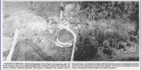
The Harper TX tornado is another good example of the SPC/NCEI data not really being truthful. Officially it had a 3.5 mile, 200 yard wide path. Not only is the visible track on satellite at least 700 yards wide and 5.2 miles as a straight line between the ends, but a plausible interpretation of the path comes to 8.2 miles:

Screen Shot 2025-04-20 at 11.00.37 pm.png
 
Another Palm Sunday tornado that's not very well-known but was pretty intense (although it thankfully avoided any bigger towns) - the DeWitt-Laingsburg, MI F4:

N3rM1vJ.jpeg


T8XKKko.jpeg


a3qVQrf.jpeg


x9LvH1N.jpeg


WqsAhRc.jpeg


x3tl93b.png
 
That frame grab was moments before Brandon Copic and/or Vince Waelti damn near drove into the thing from the west...in the middle of the screen I think that's the roof you hear them screaming about on the radio.

And yeah, if it was a direct hit on a town it would probably have ended up as one of the "dreaded" 190-195 MPH EF4s. :rolleyes:
 
That frame grab was moments before Brandon Copic and/or Vince Waelti damn near drove into the thing from the west...in the middle of the screen I think that's the roof you hear them screaming about on the radio.
I think I remember watching one of their streams and hearing them scream about that roof. I seriously cannot believe that storm still happened.
 
That frame grab was moments before Brandon Copic and/or Vince Waelti damn near drove into the thing from the west...in the middle of the screen I think that's the roof you hear them screaming about on the radio.

And yeah, if it was a direct hit on a town it would probably have ended up as one of the "dreaded" 190-195 MPH EF4s. :rolleyes:
Do you remember when there was an EF5 DI accidentally added to the DAT? I am quite ashamed to say that I actually at first thought it could’ve been it because the context imo was pointing to a very high caliber tornado.
 
If yall don't mind me posting more tri-state, Jackson County Historical Society had by far the most extensive photo collection out of all the societies who aided me in acquiring what is now a 2,000 photograph collection of damage (no photos of the actual tornado sadly). Here are a series of insane Panoramic views from JCHS and Nick Quigley. Some have been downscaled due to ridiculous size.

1745176798403.png
1745176970226.jpeg
1745177004151.png
1745177096249.jpeg
1745177261632.jpeg
1745177476795.jpeg
1745177646073.jpeg
part 1.
 

Attachments

  • 1745176831917.jpeg
    1745176831917.jpeg
    9.2 MB · Views: 0
  • 1745177046103.jpeg
    1745177046103.jpeg
    8.8 MB · Views: 0
  • 1745177321834.jpeg
    1745177321834.jpeg
    9.8 MB · Views: 0
Based on recent discussions in this thread about Palm Sunday '65, figured I'd throw my hat in the ring and give my subjective opinions on which tornadoes from that outbreak deserved F5 ratings:

Perhaps somewhat controversially, my #1 pick is Coldwater Lake (the first tornado). Most people jump to Pittsfield or Sunnyside, both of which are rated F5 by Grazulis and absolutely deserved those ratings - and if anything, I'd consider Sunnyside to be a very close second. But Coldwater Lake had literally everything and there's even a chance it might pass EF5 muster today. Many homes were swept away (some of which basically disappeared with no debris remaining), vehicles were hurled and mangled/stripped to their frames, and trees were debarked. At least one of the homes it swept away was well-built and anchor bolted to its foundation. The tornado also looks to have produced some pretty nasty scouring and granulation, but I can't say with 100% certainty (@locomusic01 mind helping me out a bit here?)

Obviously Sunnyside is a very close second. The contextual damage really says it all with that one - intense debarking, granulation, vehicle mangling, scouring, wind rowing, tractors being mangled including one that was torn in half... you get the idea. To be honest it's almost too close to call between Sunnyside and Coldwater Lake, with the single deciding factor being that photos clearly show anchor bolted homes swept away by Coldwater Lake (regardless of construction, I do agree Sunnyside was an F5 though).

Pittsfield comes in third, also an extremely violent tornado. The entire town was destroyed, killing seven of the 50 residents there. One home was swept away so violently that its basement was left drenched in scoured mud, though it was on a block foundation. Also remember posting a photo of what appeared to be some sort of large object (a door?) that was literally shoved into a tree.

Greentown comes in fourth. That tornado produced some pretty incredible wind rowing, scouring and threw vehicles up to a half mile away. Not quite as egregious as the first two, but still probably deserved an F5 rating.

Rainbow Lake and Toledo are definitely borderline, and I think high-end F4 is acceptable for both but a strong case for F5 can be made there.

Comstock Park looks nasty, but I can't tell how much of the 'muddy' appearance in the Six Mile Road area is true scouring so I'd put it in the "borderline" category with the previous two.

Midway/Goshen seems borderline as well, but haven't seen many good photos from that one.

Haven't seen any photos from Cambria/Mulberry/Moran or the second Coldwater Lake tornado, so I have no idea if they are F5 candidates or not.

Sheridan and Berne were definitely extremely violent, but haven't seen anything from them that screams F5.

F4 seems appropriate for Conway, DeWitt and Swanders based on damage photos I've seen.

Haven't seen many photos from Tipton/Lowden, Crystal Lake or Bluffton, though F4 seems appropriate for those tornadoes as well.

That covers all of the F4's. Not aware of any F5 candidates from that outbreak that were rated F3 or even lower, though I am well aware of some "F1"s and an F2 (Williams Bay, Monroe and Watertown) that deserved higher ratings.
 
I've seen some recent discussion here implying that several of the 1974 Super Outbreak F5s - namely, Depauw, one or both Tanner tornadoes, and Xenia - were probably not F5s. Based on damage pictures I've seen over the years (granted, I don't have access to the best ones at the moment), I don't agree.

I understand that not every destroyed Xenia home was especially well-built, but windrowing, intense ground markings, and some granulation were all present. With Depauw, we see signs of the same in available pictures, such as the one below. There are also some tornadoes I'd like to see more information about, notably Mannsville, Kentucky and Murphy, North Carolina (which apparently did extreme damage in the Appalachian forests).

Now, I would agree with one recent post that the Palm Sunday '65 tornadoes were often a cut above (excluding Guin and Brandenburg).
 

Attachments

  • Depauw_16.png
    Depauw_16.png
    2.6 MB · Views: 0
IMG_8685.jpeg
This image might be one of the most emotionally beautiful photos i’ve ever seen.
It’s so shocking to see how instantaneous a landscape can be destroyed by a tornado and how beautiful the weather can be the days after. This image from Washington, IL really shows that perfectly. Cannot believe it’ll be 12 years since that beast this year.
 
I've seen some recent discussion here implying that several of the 1974 Super Outbreak F5s - namely, Depauw, one or both Tanner tornadoes, and Xenia - were probably not F5s. Based on damage pictures I've seen over the years (granted, I don't have access to the best ones at the moment), I don't agree.

I understand that not every destroyed Xenia home was especially well-built, but windrowing, intense ground markings, and some granulation were all present. With Depauw, we see signs of the same in available pictures, such as the one below. There are also some tornadoes I'd like to see more information about, notably Mannsville, Kentucky and Murphy, North Carolina (which apparently did extreme damage in the Appalachian forests).

Now, I would agree with one recent post that the Palm Sunday '65 tornadoes were often a cut above (excluding Guin and Brandenburg).

Loco's post on Xenia shows it was definitely F5-worthy while going through the Arrowhead subdivision area:


I've seen some recent discussion here implying that several of the 1974 Super Outbreak F5s - namely, Depauw, one or both Tanner tornadoes, and Xenia - were probably not F5s. Based on damage pictures I've seen over the years (granted, I don't have access to the best ones at the moment), I don't agree.

I understand that not every destroyed Xenia home was especially well-built, but windrowing, intense ground markings, and some granulation were all present. With Depauw, we see signs of the same in available pictures, such as the one below. There are also some tornadoes I'd like to see more information about, notably Mannsville, Kentucky and Murphy, North Carolina (which apparently did extreme damage in the Appalachian forests).

Now, I would agree with one recent post that the Palm Sunday '65 tornadoes were often a cut above (excluding Guin and Brandenburg).
Loco's post on Xenia shows it was definitely F5-worthy while going through the Arrowhead subdivision area:


[link]
I was previously quite skeptical based on a lot of what I have heard about it, but after seeing the windrowing present in Arrowhead, I can definitely see why it was granted the F5 rating.

Is it really true, though, that Fujita debated granting this tornado an "F6" rating? Seems like a pretty regular high-end violent / F5 to me. Nothing in particular puts this above the 1965 Palm Sunday monsters or even some of the high-end EF4s from 4/27/2011.
I remember seeing a paper from a site somewhere showing that he did initially grant the Xenia, OH tornado an F6 rating, but changed it to an F5. I’m not making that up. I did see it somewhere. I’ll have to try and find it.

From what I know, Fujita also considered rating the Smithfield, AL 1977 F5 an F6, as well as Lubbock.
 
Going off topic here, but one of the case studies I would love done, is the October 25th-26th 2010 Derecho/Tornado Outbreak that swept across MO/IL/IN/MI/OH. This event was so unique because it was the second strongest non-tropical cyclone to hit the United States, hitting a minimum pressure of 955.2 mb. This cyclone on top of producing a derecho/tornado outbreak, also produced a blizzard in Minnesota and Wisconsin.

This was also very unique, because I remember being woken up at 3:00 AM for a Tornado Watch. By the time I got on the bus for school (I was 8 years old) at 6:45-7:00 AM, the temperature was around 75 - 80 degrees. Mind you, this was late October. Storm ended up hitting at 8:30-9:00 AM and we had to take cover for a Tornado Warning. Truly one of the most bizarre storm systems. 1000079416.jpg
1000079417.png
1000079414.png
 
Back
Top