• Welcome to TalkWeather!
    We see you lurking around TalkWeather! Take the extra step and join us today to view attachments, see less ads and maybe even join the discussion.
    CLICK TO JOIN TALKWEATHER

Severe WX Severe threat 3/30-3/31

One final run of my WRF-ARW is running now for this event. Results will be forthcoming soon.

Just a quick look, though, here's my model using 0z initial conditions vs the live radar from the NWS. Doing a decent job in the short-term I think!


Output details coming soon. It's up to about Forecast Hour 11 right now.


test123.png1743395540474.png
 
One final run of my WRF-ARW is running now for this event. Results will be forthcoming soon.

Just a quick look, though, here's my model using 0z initial conditions vs the live radar from the NWS. Doing a decent job in the short-term I think!


Output details coming soon. It's up to about Forecast Hour 11 right now.


View attachment 37908View attachment 37907
Tornadic cells to come overnight?
 
Okay, so here's the results so far, that covers up to 12z at 7 AM CDT. More results as they come in!


At 1 AM CDT, this run shows a widespread damaging wind event. Of course, embedded tornadoes and hail are still a concern, too.

1743396074389.png


Same threats at 2 AM CDT, but notice the QLCS starting to blossom over in MS. That's been persistent for several runs now.

1743396199086.png


3 AM same story:


1743396280331.png


And 4 AM:

1743396358177.png


5 AM, the QLCS is pushing through MS now.

1743396426998.png


6 AM, wind and tornado threat continues across MS.

1743396505466.png
And finally, for this post, 7 AM CDT, with 70+ mph winds moving into north-central AL.


1743396628502.png


So the overnight threat continues to look primarily wind-driven, but spin-up embedded tornadoes and pockets of hail remain possible.
 
Okay, so here's the results so far, that covers up to 12z at 7 AM CDT. More results as they come in!


At 1 AM CDT, this run shows a widespread damaging wind event. Of course, embedded tornadoes and hail are still a concern, too.

View attachment 37909


Same threats at 2 AM CDT, but notice the QLCS starting to blossom over in MS. That's been persistent for several runs now.

View attachment 37910


3 AM same story:


View attachment 37911


And 4 AM:

View attachment 37912


5 AM, the QLCS is pushing through MS now.

View attachment 37913


6 AM, wind and tornado threat continues across MS.

View attachment 37914
And finally, for this post, 7 AM CDT, with 70+ mph winds moving into north-central AL.


View attachment 37916


So the overnight threat continues to look primarily wind-driven, but spin-up embedded tornadoes and pockets of hail remain possible.
Thank ya @wx_guy ! Yeah was curious because new tornado watch mentions few supercells over northern ms
 
Okay, so here's the results so far, that covers up to 12z at 7 AM CDT. More results as they come in!


At 1 AM CDT, this run shows a widespread damaging wind event. Of course, embedded tornadoes and hail are still a concern, too.

View attachment 37909


Same threats at 2 AM CDT, but notice the QLCS starting to blossom over in MS. That's been persistent for several runs now.

View attachment 37910


3 AM same story:


View attachment 37911


And 4 AM:

View attachment 37912


5 AM, the QLCS is pushing through MS now.

View attachment 37913


6 AM, wind and tornado threat continues across MS.

View attachment 37914
And finally, for this post, 7 AM CDT, with 70+ mph winds moving into north-central AL.


View attachment 37916


So the overnight threat continues to look primarily wind-driven, but spin-up embedded tornadoes and pockets of hail remain possible.
Really appreciate you doing this for us @wx_guy
 
Okay, so here's the results so far, that covers up to 12z at 7 AM CDT. More results as they come in!


At 1 AM CDT, this run shows a widespread damaging wind event. Of course, embedded tornadoes and hail are still a concern, too.

View attachment 37909


Same threats at 2 AM CDT, but notice the QLCS starting to blossom over in MS. That's been persistent for several runs now.

View attachment 37910


3 AM same story:


View attachment 37911


And 4 AM:

View attachment 37912


5 AM, the QLCS is pushing through MS now.

View attachment 37913


6 AM, wind and tornado threat continues across MS.

View attachment 37914
And finally, for this post, 7 AM CDT, with 70+ mph winds moving into north-central AL.


View attachment 37916


So the overnight threat continues to look primarily wind-driven, but spin-up embedded tornadoes and pockets of hail remain possible.
So does that mean no chance of Supercells?
 
Thank ya @wx_guy ! Yeah was curious because new tornado watch mentions few supercells over northern ms
Yeah, I'm curious as well! My model (shown below) shows the biggest tornado risk (5 out of 10) in the purple area highlighted for the next few hours. There's a small 6 out of 10 just south of Nashville, but that's just semantics. The tornado forecast. here is a very tough one, so I kinda just wanna flip a coin and call it lol but yeah.

StormNET has a similar area highlighted in the 3-hour tornado probs.


1743397954975.png


1743398130309.png
 
At 9 AM central:

1743399317565.png


10 AM Central:


1743399354819.png


Noon CDT with a High threat for severe winds in S AL.
1743399392151.png


1 PM CDT, with large hail cores starting to show up.

1743399453112.png


2 PM CDT/ 3 PM EDT shows widespread severe winds:


1743399526909.png


3 PM CDT / 4 PM EDT: Widespread severe weather (but not seeing a ton of tornado signatures, which is good!). Curiously, I see the first Flash Flood threat over in eastern Georgia, first time I've seen that pop up in either testing or real runs.


1743399578137.png

4 PM CDT / 5 PM EDT:


1743399697324.png


5 PM CDT / 6 PM EDT: The wind threat continues, but a Flash Flood threat is rising greatly in some areas due to training of cells over several hours. S AL high a couple of "High" risk areas for Flash Flooding.

1743399744267.png


6 PM CDT / 7 PM EDT: The Flash Flooding risk continues.

1743399848057.png


So that basically takes us a full 24 hours into the future and to the end of this event. I looked into some of the numbers, and some areas in S AL and the FL Panhandle are showing up on the model getting 3-6 inches of rainfall in less than 3 hours, so if that training scenario plays out, there could be some real flash flooding at least in certain areas.
 
At 9 AM central:

View attachment 37922


10 AM Central:


View attachment 37923


Noon CDT with a High threat for severe winds in S AL.
View attachment 37924


1 PM CDT, with large hail cores starting to show up.

View attachment 37925


2 PM CDT/ 3 PM EDT shows widespread severe winds:


View attachment 37926


3 PM CDT / 4 PM EDT: Widespread severe weather (but not seeing a ton of tornado signatures, which is good!). Curiously, I see the first Flash Flood threat over in eastern Georgia, first time I've seen that pop up in either testing or real runs.


View attachment 37927

4 PM CDT / 5 PM EDT:


View attachment 37928


5 PM CDT / 6 PM EDT: The wind threat continues, but a Flash Flood threat is rising greatly in some areas due to training of cells over several hours. S AL high a couple of "High" risk areas for Flash Flooding.

View attachment 37929


6 PM CDT / 7 PM EDT: The Flash Flooding risk continues.

View attachment 37930


So that basically takes us a full 24 hours into the future and to the end of this event. I looked into some of the numbers, and some areas in S AL and the FL Panhandle are showing up on the model getting 3-6 inches of rainfall in less than 3 hours, so if that training scenario plays out, there could be some real flash flooding at least in certain areas.
Thank ya @wx_guy
 
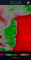
At least three areas of rotation on this line segment. All are liable to intensify. Actually, scratch that, as I'm typing the northernmost circulation has become more pronounced.
KGWX - Super-Res Storm Relative Velocity 1, 6_42 AM.pngKGWX - Super-Res Storm Relative Velocity 1, 6_44 AM.png
 
Back
Top