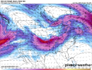
Hot off the presses, my WRF-ARW model run. It is centered on Nashville, TN and uses 06Z GFS initial conditions. It's at 9 km resolution, so somewhat in between the HRRR and GFS.
First off, look at that huge moist warm sector! Wow! You can see as the front moves through, the model is picking up on 30-50 mph winds moving through Tennessee.
View attachment 37199
View attachment 37201
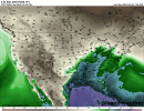
Let's look at the radar. Here's a few static images showcasing a round of discrete cells followed by a more semi-linear mode.
View attachment 37202
View attachment 37203
View attachment 37204
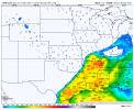
For severe metrics, here's Surface Based CAPE, showing an area of MS/AL/TN with highly elevated storm fuel:
View attachment 37205
And the approximate STP (may be a bit overdone, but it's a good approximation):
View attachment 37206

.png")
.png")
.png")
.png")