
Navigation
Install the app
How to install the app on iOS
Follow along with the video below to see how to install our site as a web app on your home screen.
Note: This feature may not be available in some browsers.
More options
-
Welcome to TalkWeather! We see you lurking around TalkWeather! Take the extra step and join us today to view attachments, see less ads and maybe even join the discussion. CLICK TO JOIN TALKWEATHER
You are using an out of date browser. It may not display this or other websites correctly.
You should upgrade or use an alternative browser.
You should upgrade or use an alternative browser.
Severe WX Severe threat 3/30-3/31
- Thread starter Bulkshear
- Start date
It's also interesting the SPC has issued more 15% 6-7 day outlooks this spring already than all the previous years combined (iirc). 2 of the 3 we've had haven't verified and never looked like huge threats on the models. Maybe a change in policy to make up for a lack in manpower with recent cuts?
Edit: All 3 have verified to some degree
Edit: All 3 have verified to some degree
Last edited:
Mrgolfman7070
Member
You thinking overdone already with this one?It's also interesting the SPC has issued more 15% 7 day outlooks this spring already than all the previous years combined (iirc). 2 of the 3 we've had haven't verified and never looked like huge threats on the models. Maybe a change in policy to make up for a lack in manpower with recent cuts?
AJS
Member
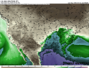
Good grief… lots of ample cape situated over Houston.Here's what it looks like at 18z Sunday. 500mb, dewpoints, and CAPE
Can you provide proof of this lack of verification?It's also interesting the SPC has issued more 15% 7 day outlooks this spring already than all the previous years combined (iirc). 2 of the 3 we've had haven't verified and never looked like huge threats on the models. Maybe a change in policy to make up for a lack in manpower with recent cuts?
AJS
Member
I will admit, those are some high CAPE values being this far out.Oh man, those CAPE values are extremely high for being this far out. Hopefully that downtrends a bit, but there aren't any systems expected to clear any of it out before the weekend right?
Also, I've been noticing the GFS seems to overestimate kinematics, and the Euro underestimates with these systems, is that right? Which one would you guys say did a better job verifying with the last system? I feel like I've mostly been seeing a preference towards the Euro from meteorologists, and the GFS is viewed as more of a hype machine? If the Euro doesn't see much of a threat yet maybe it's a good sign.
AJS
Member
What’s the 4/4-4/6 one showing right now? Been busy with classes so haven’t had time to check.It’s at the end of the Euro’s range but its zonal trough after zonal trough from 3/28 onward. That one on 4/4-4/6 could be dangerous, but it’s so far out so grain of salt.
ashtonlemleywx
Member
JP, I found a PDS tor sounding near Bolivar, Tennesee on the TN/MS State line for Sunday from today's 12z GFS.12z Euro does show the threat as far as robust dewpoints, but it's 500mb level has some work to do
What I don't understand is how is the 3cape only 16? Typically it's much higher to be a "PDS Tor" sounding.

Or maybe it's because we've had a lack of big Spring tornado seasons the last few years. When I say big, I mean one right after another. Conga line so to speak. The Deep South has had it's fair share of outbreaks the last few years, but we've really haven't had busy April since..... Well, you know when. I don't work at SPC nor do I know their criteria for issuing 15%/30% outlooks beyond the Day 5 timeframe. However, I do know that some have worked there for 20+ years now and have a general feel for the pattern. When you see them issue Day 5+ outlooks, you start thinking and planning. Not say well, it's gonna bust before it even happens. They know what they're doing.
I'm not even remotely qualified to make that call. Just pointing out what we've seen this year so far. I'll let someone else answer your question, but gotta remember a 15% risk of severe weather means there's an 85% chance of none. They can't go any higher than 30% this far out, and the reason is it's just impossible to predict anything with much certainty when even the best models are still changing with every run. 15% risk has seemed perfectly reasonable (all 4 times they've used it this year) to me.You thinking overdone already with this one?
Not overdone, legit chance for something significant this weekend. (Not nescarilly tornadoes)You thinking overdone already with this one?
Mrgolfman7070
Member
I have a friend of mine who used to work for SELS before it became SPC. It was in Kansas city mo back then. When he gets concerned, look out!! LolOr maybe it's because we've had a lack of big Spring tornado seasons the last few years. When I say big, I mean one right after another. Conga line so to speak. The Deep South has had it's fair share of outbreaks the last few years, but we've really haven't had busy April since..... Well, you know when. I don't work at SPC nor do I know their criteria for issuing 15%/30% outlooks beyond the Day 5 timeframe. However, I do know that some have worked there for 20+ years now and have a general feel for the pattern. When you see them issue Day 5+ outlooks, you start thinking and planning. Not say well, it's gonna Forecasted Convective Amplification Deficiency before it even happens. They know what they're doing.
The capping inversion is one of the main reasons why there's less 0-3 km CAPE, because the cap there is lower than 3 km in elevation (between 850 and 700 mb). This is also in the process of BL mixing, which increases 0-3 km CAPE through deepening of the moisture profile.JP, I found a PDS tor sounding near Bolivar, Tennesee on the TN/MS State line for Sunday from today's 12z GFS.
What I don't understand is how is the 3cape only 16? Typically it's much higher to be a "PDS Tor" sounding.
View attachment 37213
tennessee storm chaser
Member
- Messages
- 1,876
- Reaction score
- 4,283
- Location
- jackson tennessee
- Special Affiliations
- SKYWARN® Volunteer
Should be severe storms forecast center ….I have a friend of mine who used to work for SELS before it became SPC. It was in Kansas city mo back then. When he gets concerned, look out!! Lol
Back in the day Kansas City
Mrgolfman7070
Member
What's your take on the 12z euro?Should be severe storms forecast center ….
Back in the day Kansas City
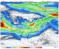
Just off the 12z euro simulated precip; it looks like a doozy Sunday afternoon through Monday morning.

Last edited:
ARCC
Member
Just off the 12z euro simulated precip; it looks like a doozy Sunday afternoon through Monday morning.
View attachment 37220
Euro is just plain nasty from the TN/KY line to South of Montgomery.

Yup, not the look you want to see. Zonal type systems like this can be very nasty for the deep south.Euro is just plain nasty from the TN/KY line to South of Montgomery.
Can you provide proof of this lack of verification?
Ask and you shall receive... Man, this was time consuming! I should say I guess it depends on how you define verification?
The day 6 outlook on 03/18 called for "thunderstorms with a threat for isolated large hail (2 inches or larger) and severe gusts (58 mph+) are expected to develop along the northern edge of the moist sector"
Here's the storm reports for 03/23. There was no hail 2 inches or larger, and 4 of the wind reports specified 60-80 mph winds. Though, there were two reports of 3 and 1 downed powerlines, and around a dozen downed trees. There was also an EF1 tornado that knocked down a few trees and powerlines. So I'd say the wind prediction maybe verified, but the hail didn't?


On 02/27 there was a day 6 15-30% risk, and a day 7 15% risk issued. The day 6 called for "the potential for multiple rounds of severe convection including supercells, clusters, and likely an eventual squall line will likely bring a threat for all severe weather hazards including strong tornadoes." The day 7 was less specific but called for "
Low to mid 60s dewpoints in the presence of a very strong wind field will support a large area of severe weather threat"
Here's the storm reports for 03/04. There were 26 tornado reports but no strong tornadoes (all were EF1 or less), and 15 separate severe wind gusts (58 mph+) reported, with max straight line winds reaching 70-90 mph. Too many reports of downed trees and powerlines to count. An image of hail was reported with one being large (3 inches) and the rest being 1.5 inches. So for this one, the strong tornado risk didn't verify, severe wind gusts absolutely did, and the large hail is iffy but single isolated report could count as borderline?


Storm reports for 03/05. Three severe wind gusts reports of 60-80mph, one downed electrical pole, and several reports of trees downed. An EF1 and EF0 tornado. 0 hail reports. Interesting report of "several rail cars pushed off their track" near Richland, SC. I'd call this one borderline as well, but the rail cars report is very interesting and may be evidence of isolated verification.


And we all know how the 03/09 Day 6 and 7 panned out. 100% undeniably verified and then some. This is the first time i've looked at storm reports since the day after the event. 170 tornado reports is just absolutely bonkers.


