
Navigation
Install the app
How to install the app on iOS
Follow along with the video below to see how to install our site as a web app on your home screen.
Note: This feature may not be available in some browsers.
More options
-
Welcome to TalkWeather! We see you lurking around TalkWeather! Take the extra step and join us today to view attachments, see less ads and maybe even join the discussion. CLICK TO JOIN TALKWEATHER
You are using an out of date browser. It may not display this or other websites correctly.
You should upgrade or use an alternative browser.
You should upgrade or use an alternative browser.
Severe Weather 2025
- Thread starter KevinH
- Start date


AJS
Member
Definitely still considering chasing. Might consider heading to the Delta if time allows.Models continue to hone in on the 3/23 threat:
View attachment 36838
View attachment 36839
View attachment 36840
From MEG on Sunday:
"Deterministic runs of
both the GFS and ECMWF paint SBCAPE values upwards of 1500 J/kg
and 0-6 km bulk shear upwards of 55 kts in the aforementioned
area. This great thermodynamic environment will allow strong to
severe storms to produce damaging winds, large hail, and a
possible tornado or two."
That'll do it.
Kds86z
Member
Oh dang..From MEG on Sunday:
"Deterministic runs of
both the GFS and ECMWF paint SBCAPE values upwards of 1500 J/kg
and 0-6 km bulk shear upwards of 55 kts in the aforementioned
area. This great thermodynamic environment will allow strong to
severe storms to produce damaging winds, large hail, and a
possible tornado or two."
That'll do it.
AJS
Member
Dang, that might be the most descriptive forecast i’ve ever seen MEG put out!From MEG on Sunday:
"Deterministic runs of
both the GFS and ECMWF paint SBCAPE values upwards of 1500 J/kg
and 0-6 km bulk shear upwards of 55 kts in the aforementioned
area. This great thermodynamic environment will allow strong to
severe storms to produce damaging winds, large hail, and a
possible tornado or two."
That'll do it.
Grand Poo Bah
Member
Here's some interesting data for the research minded people in here.
1. Billion dollar disaster weather events (adjusted for inflation):

I was intrigued by how much "Severe Storms" have gone up compared to other categories. It's interesting, storms are far more destructive than ever, yet we haven't seen an EF5 in 12 years. Talk about a discrepancy.
Important Note: Tropical Cyclones still do far more damage. They're just $22.2B per event compared to $2.4B for Severe Storms. Severe storms are just a far more frequent disaster.

2. Info I've collected and organized about 100+ tornado outbreaks. These graphs show an increase in the severity of outbreaks, but also advancements in tornado detection, so should be taken with a grain of salt. I grouped them into four year periods because it was easiest way to divide the most decades, while aligning best with El Nino and El Nina climate patterns.. It's worth noting, there haven't been any 100+ tornado hurricane outbreaks since Hurricane Rita in 2005, and 2004 had two hurricane outbreaks (and a November outbreak)
Here's all 100+ tornado outbreak sequences.

Here's 100+ tornadoes outbreak sequences with a duration of 5 days or less

3. All 100+ tornado outbreak sequences sorted by number of tornadoes

4. All 100+ tornado outbreak sequences sorted by year. It looks like a pretty even distribution until you realize there's only been 4 complete tornado seasons in the 2020s. And we just added another 100+ last weekend, bringing the 2020s to 8 total. The 2000s had the most with 10.

5. The results are especially quizzical when you sort it by duration. 3 of the 10 shortest 100+ outbreaks occurred in 2004, and none of them were during the typical tornado season. 2020s also have 4 of the shortest 8 (if you add last weekend). I was going to call these the "most severe outbreaks" (most tornadoes in the least time), but realized that'd be inaccurate because a lot of outbreaks probably had more severe 1 or 2 day stretches, but the overall outbreaks were much longer.

@Fred Gossage @Matt Grantham does any of this relate to your research at all?
1. Billion dollar disaster weather events (adjusted for inflation):
I was intrigued by how much "Severe Storms" have gone up compared to other categories. It's interesting, storms are far more destructive than ever, yet we haven't seen an EF5 in 12 years. Talk about a discrepancy.
Important Note: Tropical Cyclones still do far more damage. They're just $22.2B per event compared to $2.4B for Severe Storms. Severe storms are just a far more frequent disaster.
2. Info I've collected and organized about 100+ tornado outbreaks. These graphs show an increase in the severity of outbreaks, but also advancements in tornado detection, so should be taken with a grain of salt. I grouped them into four year periods because it was easiest way to divide the most decades, while aligning best with El Nino and El Nina climate patterns.. It's worth noting, there haven't been any 100+ tornado hurricane outbreaks since Hurricane Rita in 2005, and 2004 had two hurricane outbreaks (and a November outbreak)
Here's all 100+ tornado outbreak sequences.
Here's 100+ tornadoes outbreak sequences with a duration of 5 days or less
3. All 100+ tornado outbreak sequences sorted by number of tornadoes
4. All 100+ tornado outbreak sequences sorted by year. It looks like a pretty even distribution until you realize there's only been 4 complete tornado seasons in the 2020s. And we just added another 100+ last weekend, bringing the 2020s to 8 total. The 2000s had the most with 10.
5. The results are especially quizzical when you sort it by duration. 3 of the 10 shortest 100+ outbreaks occurred in 2004, and none of them were during the typical tornado season. 2020s also have 4 of the shortest 8 (if you add last weekend). I was going to call these the "most severe outbreaks" (most tornadoes in the least time), but realized that'd be inaccurate because a lot of outbreaks probably had more severe 1 or 2 day stretches, but the overall outbreaks were much longer.
@Fred Gossage @Matt Grantham does any of this relate to your research at all?
Attachments
Last edited:
Grand Poo Bah
Member
@Fred Gossage I'd love to add a column to the table for TNI scores. and sort by that.
tennessee storm chaser
Member
- Messages
- 1,863
- Reaction score
- 4,242
- Location
- jackson tennessee
- Special Affiliations
- SKYWARN® Volunteer
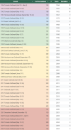
Thought a tornado In Arkansas last Friday night was up graded to ef5…..Here's some interesting data for the research minded people in here.
1. Billion dollar disaster weather events (adjusted for inflation):
View attachment 36858
I was intrigued by how much "Severe Storms" have gone up compared to other categories. It's interesting, storms are far more destructive than ever, yet we haven't seen an EF5 in 12 years. Talk about a discrepancy.
Important Note: Tropical Cyclones still do far more damage. They're just $22.2B per event compared to $2.4B for Severe Storms. Severe storms are just a far more frequent disaster.
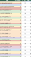
View attachment 36859
2. Info I've collected and organized about 100+ tornado outbreaks. These graphs show an increase in the severity of outbreaks, but also advancements in tornado detection, so should be taken with a grain of salt. I grouped them into four year periods because it was easiest way to divide the most decades, while aligning best with El Nino and El Nina climate patterns.. It's worth noting, there haven't been any 100+ tornado hurricane outbreaks since Hurricane Rita in 2005, and 2004 had two hurricane outbreaks (and a November outbreak)
Here's all 100+ tornado outbreak sequences.
View attachment 36860
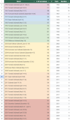
Here's 100+ tornadoes outbreak sequences with a duration of 5 days or less
View attachment 36861
3. All 100+ tornado outbreak sequences sorted by number of tornadoes
View attachment 36862
4. All 100+ tornado outbreak sequences sorted by year. It looks like a pretty even distribution until you realize there's only been 4 complete tornado seasons in the 2020s. And we just added another 100+ last weekend, bringing the 2020s to 8 total. The 2000s had the most with 10.
View attachment 36867
5. The results are especially quizzical when you sort it by duration. 3 of the 10 shortest 100+ outbreaks occurred in 2004, and none of them were during the typical tornado season. 2020s also have 4 of the shortest 8 (if you add last weekend). I was going to call these the "most severe outbreaks" (most tornadoes in the least time), but realized that'd be inaccurate because a lot of outbreaks probably had more severe 1 or 2 day stretches, but the overall outbreaks were much longer.
View attachment 36866
@Fred Gossage @Matt Grantham does any of this relate to your research at all?
AJS
Member

Slight risk has been issued for Sunday.
MoonBaby
Knew It Would Happen
Next time anyone chases near Tuscaloosa let me know and I will show you around! Hopefully no storms come here though. But still. I saw a whole swarm of storm chasers on the way to the shelter last Saturday.
tennessee storm chaser
Member
- Messages
- 1,863
- Reaction score
- 4,242
- Location
- jackson tennessee
- Special Affiliations
- SKYWARN® Volunteer
Does it matter if am a Tennessee Vols fan lolNext time anyone chases near Tuscaloosa let me know and I will show you around! Hopefully no storms come here though. But still. I saw a whole swarm of storm chasers on the way to the shelter last Saturday.
keithGA
Member
Nobody's perfect.Does it matter if am a Tennessee Vols fan lol
CIPS is sniffing out something towards the end of the month. Meanwhile, there's a threat for an MCS-style wind, hail and tornado event across the TN Valley on March 23. End-of-month threats are something to just watch and wait on. Have a feeling there will be a bivvy of smaller threats before it gets active again moving towards the middle of April.

...East Texas to the Tennessee Valley...
Daytime heating ahead of the cold front will combine with ample
warm-sector dewpoints to support airmass destabilization.
Mixed-layer CAPE ranging from around 500 J/kg in western Tennessee
to 1500 J/kg or so into eastern Texas seems likely evolve, and
should be sufficient to support development of scattered
strong/locally severe storms. Updraft intensity will be aided by
weakly veering/increasing flow with height through the mid
troposphere, with shear sufficient for organized/rotating updrafts.
While a tornado or two may be possible, greater risk appears to be
hail and locally damaging wind gusts. This risk should peak through
late afternoon, after which diurnal cooling/stabilization should
result in a gradual decrease in storm intensity/severe potential.
..Goss.. 03/21/2025
cheeznado
Member
The consensus says 3/23 is going to be primarily after dark.
wx_guy
Member
- Messages
- 1,237
- Reaction score
- 4,443
- Location
- United States
- HAM Callsign
- KO4ZGH
- Special Affiliations
- SKYWARN® Volunteer
- ARRL Member
I'm running my WRF-ARW model (see thread on that topic if you want to talk about it!) using GFS 12z today as initial conditions. Going out 72 hours, so should capture Sunday's threat. I have the run centered on Oxford, MS, and if all goes well, it'll output 3 domains - an 1100 mile wide regional view, a 600 mile wide high resolution mesoscale view, and a 100 mile wide local ultra resolution view. Plan to hopefully output simulated radar. I'm still working on some of the severe weather derived metrics like STP, but yeah. Super excited to have my own own model to play with!
Not sure if this is the perfect thread for this, but I thought this new system was very interesting - could envisage a lot of 30-45% single hatched outlooks being issued for those QLCS type spam events.
Whoa! How did I not know about this? Usually, SPC puts out a link on their site of upcoming changes or stuff like this.
Right call. Looking at everything currently, this event won’t be that potent and looks to be a pretty big MCS with some embedded circulations.View attachment 36868
Slight risk has been issued for Sunday.
MoonBaby
Knew It Would Happen
I don’t like any football so it makes no difference to me hahaDoes it matter if am a Tennessee Vols fan lol