
Possible tornado near Elizabethtown, IN. VWP hodograph from LVX is highly favorable for tornadoes should there be enough instability.
Navigation
Install the app
How to install the app on iOS
Follow along with the video below to see how to install our site as a web app on your home screen.
Note: This feature may not be available in some browsers.
More options
-
Welcome to TalkWeather! We see you lurking around TalkWeather! Take the extra step and join us today to view attachments, see less ads and maybe even join the discussion. CLICK TO JOIN TALKWEATHER
You are using an out of date browser. It may not display this or other websites correctly.
You should upgrade or use an alternative browser.
You should upgrade or use an alternative browser.
Severe Weather 2025
- Thread starter KevinH
- Start date
cincywx
Member

might be too noisy in this frame to guarantee that it's a debris ball but nonetheless, still a tight couplet southwest of Elizabethtown, IN
cincywx
Member
BULLETIN - EAS ACTIVATION REQUESTED
Tornado Warning
National Weather Service Indianapolis IN
857 PM EDT Wed Mar 19 2025
The National Weather Service in Indianapolis has issued a
* Tornado Warning for...
Northwestern Decatur County in central Indiana...
East central Bartholomew County in central Indiana...
* Until 915 PM EDT.
* At 856 PM EDT, a confirmed tornado was located 7 miles east of
Columbus, moving northeast at 50 mph.
HAZARD...Damaging tornado.
SOURCE...Weather spotters confirmed a brief tornado earlier south
of Columbus.
IMPACT...Flying debris will be dangerous to those caught without
shelter. Mobile homes will be damaged or destroyed.
Damage to roofs, windows, and vehicles will occur. Tree
damage is likely.
* Locations impacted include...
Burney, Newbern, Milford, Hartsville, Adams, Greensburg, and
Columbus.
confirmed tornado warning, but not because of the possible debris signature
217wx
Member
QLCS along the dryline/Pacific front turned east-central Illinois into West Texas as I was driving through it earlier. Dust everywhere, I had to pull over onto a turnout. Easily had 50-60 mph winds
Kds86z
Member
Anti Marine Layer
Member
Watch me eat my words, Tornado warning in Southern Indiana.
How far is that from Louisville?
Kds86z
Member
Pardon my question, but do gustnadoes count officially as tornadoes? Like today had, I see SPC has them down.
CheeselandSkies
Member
Pardon my question, but do gustnadoes count officially as tornadoes? Like today had, I see SPC has them down.
Technically they shouldn't since they don't involve a circulation from ground to cloud base.
It’s usually in reference to a skew t (aka a sounding) and is indicative of the environment, not necessarily a storm.
You have a layer of warm and dry air above the surface that is warmer than the air parcels underneath it. That acts as a “lid” because parcels can’t “break” through it to form thunderstorms. The energy will continue to build underneath it. Parcels only rise if they are warmer than the air around them.
It’s considered a loaded gun because once the cap erodes, thunderstorms can quickly form. So the environment is loaded so to speak, but the trigger isn’t ready to get pulled.
This is a good example. This is from the morning of 4/3/74, Montgomery, Alabama. Textbook example Of a loaded gun. You can see the sudden increase to the right in temperature of the red (temperature line) and the sudden increase to the left of the green (dew point line). Indicating the temperatures are both warmer and drier than what is below it.
View attachment 36769
Really great, easy to understand explanation, and I was missing the part where the upper air is warmer than the lower air, as indicated in this sounding. Thank you!!
Kds86z
Member

Storms peel roof off school in Gary, rip down trees around Northwest Indiana
A tornado is suspected to have been to blame for some of the damage in Gary.
Not a gustnado lol
CSimonds
Member
ZCZC SPCSWOD48 ALL
ACUS48 KWNS 200858
SPC AC 200858
Day 4-8 Convective Outlook
NWS Storm Prediction Center Norman OK
0358 AM CDT Thu Mar 20 2025
Valid 231200Z - 281200Z
...DISCUSSION...
...Sunday/Day 4 and Monday/Day 5...
A large-scale cyclonic flow pattern will be in place across much of
the continental U.S. on Sunday. An upper-level low will develop over
the Great Lakes, as an associated trough moves southeastward from
the Great Plains to the Mississippi Valley. A cold front is forecast
to move southeastward into the Ozarks. Ahead of the front, moisture
advection is forecast to occur over the Sabine and lower Mississippi
Valleys, where surface dewpoints will likely be in the 60s F and
moderate instability is expected to develop. Scattered thunderstorms
appear likely to initiate ahead of the front Sunday evening from the
Sabine River Valley northeastward into the Tennessee Valley, with an
MCS developing Sunday evening. Moderate deep-layer shear will likely
support severe thunderstorm development, with a potential for severe
wind gusts, isolated large hail. A tornado threat may also develop.
A cold front is forecast to move through the Gulf Coast region
Sunday morning. Isolated severe storms could develop ahead of the
front early in the day from the Texas Coast eastward to the central
Gulf Coast and Florida Panhandle. Predictability remains low
concerning where the greatest severe threat will be along this
corridor. The severe threat should end during the day as the front
moves southward into the Gulf.
...Tuesday/Day 6 to Thursday/Day 8...
On Tuesday, a mid-level trough is forecast to dig southeastward into
the Mississippi Valley. At the surface, a moist airmass will remain
over the Gulf Coast region. Isolated strong to severe storms could
occur along the northern edge of this moist airmass. The greatest
potential for severe could be across the Sabine River Valley, where
some solutions have moderate instability Tuesday afternoon. This
appears to be a conditional severe threat, and predictability is
low.
From Wednesday into Thursday, a relatively dry airmass is forecast
over much of the nation. The exception could be across south Texas,
where thunderstorm development will be possible. Although an
isolated severe threat would be possible there, predictability at
this extended range in the forecast cycle is low.
..Broyles.. 03/20/2025
Storm Prediction Center Jul 9, 2026 Day 4-8 Severe Weather Outlook
Severe weather, tornado, thunderstorm, fire weather, storm report, tornado watch, severe thunderstorm watch, mesoscale discussion, convective outlook products from the Storm Prediction Center.
www.spc.noaa.gov
Attachments
AJS
Member

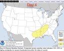
Wow, pretty big 15%. Unfortunately right in the cross hairs for this one. Definitely time for a chase.
Aaron Rider
Member
When was the last time East Texas, especially the piney woods, got a significant tornado outbreak?
AJS
Member
December 28, 2024.When was the last time East Texas, especially the piney woods, got a significant tornado outbreak?
US_Highway15
Member

Don't know if this is the same for anyone else, but it appears that the SPC website is glitched and lists the Day 4 outlook in the Day 3 slot.
Justin Hindman
Member
- Messages
- 378
- Reaction score
- 1,165
- Location
- Gardendale Alabama
- Special Affiliations
- SKYWARN® Volunteer
- ARRL Member
Very little parameters for the east side of this riskView attachment 36794
Wow, pretty big 15%. Unfortunately right in the cross hairs for this one. Definitely time for a chase.
AJS
Member
I’m on the western side. Houston suburbs.Very little parameters for the east side of this risk
on this one
It’s way out in the GEFS’ range, so grain of salt, but you don’t see a lot of “gulf scouring” for the rest of March. It’s consistent Zonal flow that keeps those typical early-spring cold front intrusions out of the gulf. So you have moisture just sitting there and then add in the additional “heating” as we move into April.
If this pattern holds, and you have a strong system come through in early-mid April, it will have plentiful moisture available just waiting to be advected northward.
A lot of your bigger outbreaks in April (sans 4/27/11) had a very zonal flow regime in March with higher pressure over the southeast that kept cold frontal intrusions from scouring the gulf. So when those systems came in, moisture was already there And was easily advected northward. It’s one of the reasons you saw such a wide expanse of warm sector on 4/3/74. Moisture built up all through March, was primed even further with a wave on 4/1/74, and you got mid-60s dew points all the way up into central Indiana/Ohio. I’m not saying it will be a repeat, but this pattern will be interesting. Palm Sunday 1965 is another good example that took advantage of this pattern.
tennessee storm chaser
Member
- Messages
- 1,876
- Reaction score
- 4,283
- Location
- jackson tennessee
- Special Affiliations
- SKYWARN® Volunteer
Just waiting for the next big mjo wave .It’s way out in the GEFS’ range, so grain of salt, but you don’t see a lot of “gulf scouring” for the rest of March. It’s consistent Zonal flow that keeps those typical early-spring cold front intrusions out of the gulf. So you have moisture just sitting there and then add in the additional “heating” as we move into April.
If this pattern holds, and you have a strong system come through in early-mid April, it will have plentiful moisture available just waiting to be advected northward.
A lot of your bigger outbreaks in April (sans 4/27/11) had a very zonal flow regime in March with higher pressure over the southeast that kept cold frontal intrusions from scouring the gulf. So when those systems came in, moisture was already there And was easily advected northward. It’s one of the reasons you saw such a wide expanse of warm sector on 4/3/74. Moisture built up all through March, was primed even further with a wave on 4/1/74, and you got mid-60s dew points all the way up into central Indiana/Ohio. I’m not saying it will be a repeat, but this pattern will be interesting. Palm Sunday 1965 is another good example that took advantage of this pattern.