SmokeEater
Member
It's noon, and there isn't a bit of convection in most of the high risk, can we chill with insinuating it's going to bust please?
Follow along with the video below to see how to install our site as a web app on your home screen.
Note: This feature may not be available in some browsers.
Yes. I apologize. Just a bit antsy rn. Plus my buddy is being a bit ignorant with the threat. Thinks it’s not gonna be bad so really worried.It's noon, and there isn't a bit of convection in most of the high risk, can we chill with insinuating it's going to Forecasted Convective Amplification Deficiency please?
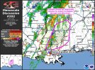
Mentions greatest threat through mid afternoon of intense to violent tornadoes will be there.There's a new meso discussion in south and South Central Mississippi but it won't let me pull it up
Bentley and the violent word..New Mesoscale Discussion for Tornado Watch 45:
"DISCUSSION...A line of supercells is developing within a confluence
band across eastern Louisiana and south-central Mississippi.
Temperatures are expected to warm into the 80s ahead of these
supercells within the next 1 to 2 hours which should aid the
maturity of multiple supercells out of this confluence band. SPC
Mesoanalysis shows STP values across the area are already 4 to 6 and
these values are expected to increase through the afternoon as shear
and instability increase further. As these supercells mature into
peak heating, they will pose a threat for long-track intense to
violent tornadoes.
Of particular interest are 2 consolidating supercells entering St.
Helena Parish in eastern Louisiana and Lincoln County in
Mississippi. These storms already have echo tops over 50kft and are
near the greatest instability. The 16Z LIX RAOB acts as a proximity
sounding to these storms with MLCAPE over 2200 J/kg and a STP of 6.
In addition, temperatures have warmed a few degrees since it was
launched. These storms, with broken cloudcover and instability
downstream in a volatile kinematic environment, have the greatest
potential to realize this environment over the next 1 to 3 hours."
We are 2-3 hours away from the main window for the event. This is really premature.Starting to wonder if the SPC may have jumped the gun; looks a bit messy out there now. Then again, they are the professionals.
That storm and the one south will probably be the best bet in South Mississippi moving forward.if i’m betting that brookhaven storm is about to take the main stage.

Yes - there’s also that mini “line” that formed to the south that looks like it’s cleaned itself up and become a supercell. I think today is going to do what it was forecasted to do.if i’m betting that brookhaven storm is about to take the main stage.
Maybe, it’s also surrounded by smaller storms to its east which could impede it.if i’m betting that brookhaven storm is about to take the main stage.
Read my latest post.We are 2-3 hours away from the main window for the event. This is really premature.
rule 4 conveniently ignores rule 27 chapter 3 subsection 1 paragraph 5 which says “thou shalt always have present those who will call an event a bust before the event even begins.”Some of y'all should really read up on the posting guidelines.
4. "It is a Forecasted Convective Amplification Deficiency" policy (updated 24MAR21)
Forecasted Convective Amplification Deficiency posts during severe weather events will not be tolerated. Just because it is sunny and clear at your house, doesn't mean other members aren't under the gun. Be respectful before you go into an active severe weather thread and declare a Forecasted Convective Amplification Deficiency. This is the type of discussion we expect in post-storm analysis. Furthermore, disrespectful Forecasted Convective Amplification Deficiency posts that specifically call out someone who made a prediction that didn't pan out are highly discouraged. Science is hard, things change and Mother Nature doesn't like us knowing her intentions.