• Welcome to TalkWeather!
    We see you lurking around TalkWeather! Take the extra step and join us today to view attachments, see less ads and maybe even join the discussion.
    CLICK TO JOIN TALKWEATHER

Severe WX Severe Weather Threat 3/14-3/16

wasn't forcing a cold front (lol)? pretty strong even if it was a relatively weak cold front
For the northern areas, yes. If you watch Trey’s video though, the further south you went, the slower and almost stationary the boundary was.

However, the supercells and CI attempts that night in Louisiana and Mississippi seemed to be purely out in the open warm sector. Probably a combination of confluence and synoptic forcing from the glancing blow of the jet. The cap was stout down there so all but one of the storms was able to mature.
In addition to this, it’s also possible to have a cold front that is subtly forced if the cold front doesn’t bring a strong temperature gradient with it. This was discussed in Trey’s video on the 5/31/85 outbreak, where the cold front was so diffuse that even with its modest eastward progression the forcing was subtle enough for discrete development.

I don’t think that applies in this case though, IIRC there was a strong temperature gradient associated with the 3/14 system. That would make sense with how intense the low was.
You pretty much nailed it. It actually was true with the 3/14 system! Per Trey’s video, the Arkansas cells formed on the cold front, but it was a very weak temperature gradient. I think 70s on one side to mid 70s on the other around Arkansas. As you went north, it was a stronger gradient, hence the linear mode to the north.
 
I think that was true for 3/15. However, on 3/14 with such subtle forcing around Mississippi and Southern Arkansas, more moisture would only have helped erode the cap further and help storms that were able to mature.
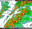
I believe it was you who said that were storm mode ever-so-slightly different during the first half of the day on 3/15, we might've been dealt the outbreak of a lifetime. Considering the radar presentation the day-of, I would concur.
KDGX_loop.gif
 
I believe it was you who said that were storm mode ever-so-slightly different during the first half of the day on 3/15, we might've been dealt the outbreak of a lifetime. Considering the radar presentation the day-of, I would concur.
I’m really looking forward to Trey’s breakdown. Mississippi definitely got the brunt of it. If that big line of crapvection showers weren’t there, I feel like all of Mississippi would have been in play vs just the southern portion. Imagine that kind of radar presentation spanning the entire state.

It did seem like the environment wasn’t as extreme in Alabama as was modeled. Still a memorable day for the state though. I’ll have to look again, so I may be wrong, but it did seem like the surface vectors in Alabama were pretty backed and weren’t exactly pulling in that pristine gulf moisture at the same volume southern Mississippi was.
It was my personal closest call in a long time that evening, so definitely memorable for me. This outbreak was also a great example of both how it takes 10,000 factors to come together perfectly to get "the outbreak", but when certain conditions are favorable, storms can overcome even the most meager of environments (i.e. every cloud in Alabama spinning by evening).
 
Reading back on this (as I wasn't here for it) was a wild ride. Even if the event didn't reach it's ceiling, it was still a very violent event on both the 14th and 15th. I will say though I was much more impressed with the 14th as a whole, especially in the southeastern MO and northeastern AR area.

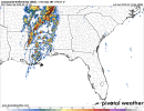
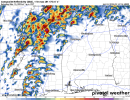
That being said, the images of model runs for the 15th made my jaw drop:

1742001378898.png
refcmp_uh001h.png

Just a little reminder of what could have been. I don't mean this lightly, but there was a very real chance the 15th alone could have been a Super Outbreak.
 
Reading back on this (as I wasn't here for it) was a wild ride. Even if the event didn't reach it's ceiling, it was still a very violent event on both the 14th and 15th. I will say though I was much more impressed with the 14th as a whole, especially in the southeastern MO and northeastern AR area.

That being said, the images of model runs for the 15th made my jaw drop:

View attachment 46856
View attachment 46858

Just a little reminder of what could have been. I don't mean this lightly, but there was a very real chance the 15th alone could have been a Super Outbreak.
That was quite the HRRR run. While this run was initialized at 0Z (so the night of the 14th) each model run after that tended to linearize and beef up that rain shield more and more.

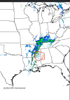
What’s interesting is we actually did get convective initiation on the AL/MS border that the model was depicting there. Like I said earlier, the environment wasn’t ready yet or wasn’t as extreme in that area. Those stayed mainly showers, dissipated super quick, or eventually moved north and weakened. You can see them here on the reflectivity:

1759332028512.png
 
That was quite the HRRR run. While this run was initialized at 0Z (so the night of the 14th) each model run after that tended to linearize and beef up that rain shield more and more.

What’s interesting is we actually did get convective initiation on the AL/MS border that the model was depicting there. Like I said earlier, the environment wasn’t ready yet or wasn’t as extreme in that area. Those stayed mainly showers, dissipated super quick, or eventually moved north and weakened. You can see them here on the reflectivity:

View attachment 46859
It's crazy to think if they had initiated later and storm mode cooperated a bit more, we would be having a much different conversation.

Another thing that impressed me was the concistancy of the models. Usually the long range models flip flop and the short range models kinda do their own thing to an extent, but with the 14-15th they were remarkably consistant in showing a deavastating scenario.
 
That was quite the HRRR run. While this run was initialized at 0Z (so the night of the 14th) each model run after that tended to linearize and beef up that rain shield more and more.

What’s interesting is we actually did get convective initiation on the AL/MS border that the model was depicting there. Like I said earlier, the environment wasn’t ready yet or wasn’t as extreme in that area. Those stayed mainly showers, dissipated super quick, or eventually moved north and weakened. You can see them here on the reflectivity:

View attachment 46859
Can't remember what was happening at that point, though I do remember as the confluence band moved into AL, DPs and CAPE still weren't that great so that likely prevented a good bit of development.
 
Although I'm not sure of the actual mechanisms of this, the 500mb jet wasn't super quick translationally which probably led to the storm mode failure on the 15th. Someone can dig up the exact details on that but per Broyles:

March 14, 2025 had a TOI High Risk Probability of 67% for the 06Z Day 1 Outlook. For March 14, 2025, TOI predicted RIV of 7.0, which the event verified at 82.21.

March 15, 2025 had a TOI High Risk Probability of 52% for the 06Z Day 1 Outlook. For March 15, 2025, TOI predicted RIV of 4.0, which the event verified at 7.11.

So in other words, the data was pretty clear that the 14th should have been the high risk over the 15th. Why they decided to do the opposite is a mystery. Apparently not all of the outlook forecasters there buy into the OMEGA project results.
 
So in other words, the data was pretty clear that the 14th should have been the high risk over the 15th. Why they decided to do the opposite is a mystery. Apparently not all of the outlook forecasters there buy into the OMEGA project results.
I don’t think it’s the fact that they don’t buy it, I’m sure it’s more of the fact that many forecasters saw more potential “flies in the ointment” on March 14 rather than March 15 before the event began. I seem to remember many people calling for a much more linear mode on March 14th than what actually happened in the higher risk contour. OMEGA is also still in its infancy, relatively speaking, so it would make sense to err on the side of caution when forecasting until we’ve seen OMEGA make more accurate predictions in the future. That will fully cement it as a much more trustworthy tool IMO.
 
So in other words, the data was pretty clear that the 14th should have been the high risk over the 15th. Why they decided to do the opposite is a mystery. Apparently not all of the outlook forecasters there buy into the OMEGA project results.
Hindsight is 20/20 as always, but I do feel like the SPC jumped the gun with the 2 day high-risk for 15th. The outlook did verify, it wasn’t a bu$t at all, but you had a lot of flies in the ointment build in between that issuance and the morning of the event. To @slenker ‘s point though, CAMS weren’t showing discrete supercells for the 14th until the morning of if I recall. Everything was just being depicted as a giant line until then. Still think they could’ve went high when the CAMs latched onto that solution for the 14th though.
 
Hindsight is 20/20 as always, but I do feel like the SPC jumped the gun with the 2 day high-risk for 15th. The outlook did verify, it wasn’t a bu$t at all, but you had a lot of flies in the ointment build in between that issuance and the morning of the event. To @slenker ‘s point though, CAMS weren’t showing discrete supercells for the 14th until the morning of if I recall. Everything was just being depicted as a giant line until then. Still think they could’ve went high when the CAMs latched onto that solution for the 14th though.
Concur. Worth remembering that the 14th basically went the opposite of the 15th on models; it really didn't look overwhelmingly impressive until the day-of, and I do think there was genuinely just some extra focus put on the 15th because of how insane it looked - those kinds of soft biases can effect anyone, including seasoned forecasters. That being said, the D2 High Risk was certainly an interesting choice, though at the time I still understand why they pulled on it. Their placement was good, too - a lot of us were concerned it wasn't far enough north, but it was right where it needed to be.
 
Trey’s video on the 15th is up. Really good explanation and overview of the event. Turns out, the morning convection really didn’t temper the event in the ways I thought. May have decreased instability in the northern portion and cut off the northern parts of the risk areas. The biggest culprits were extremely saturated profiles and a weak cap. Really impacted storm mode, as we all saw, and really tempered the event relative to expectations.

Edit: also forgot the other culprit. The main jet streak not directly impacting the event as the tornadic supercells were ongoing.

 
Back
Top