
It's definitely an individual radar site issue and it's usually the public that has to remind them of this during severe weather eventsIs it just a quirk of GR Level 3 on certain NEXRAD sites (such as KHDC this morning and, almost every time I use it, KDGX) or are an alarming number of NWS offices consistently forgetting to operate their radars in SAILS mode during severe weather events, so you only get a volume scan every 5-7 minutes instead of 2-3? The difference is an eternity in "tornado time."
Navigation
Install the app
How to install the app on iOS
Follow along with the video below to see how to install our site as a web app on your home screen.
Note: This feature may not be available in some browsers.
More options
-
Welcome to TalkWeather! We see you lurking around TalkWeather! Take the extra step and join us today to view attachments, see less ads and maybe even join the discussion. CLICK TO JOIN TALKWEATHER
You are using an out of date browser. It may not display this or other websites correctly.
You should upgrade or use an alternative browser.
You should upgrade or use an alternative browser.
Severe Weather Threat 12.26-12.29.2024
- Thread starter JBishopwx
- Start date
12z nam looks robust into most of Alabama. As well as the 12z hrrr. I'm wondering if your seeing a shift into a bigger threat into Alabama.
Equus
Member
It's kind of remarkable how long it's been since a significant severe threat in this corridor; BMX is still near record low tornado warning count for the year. Watching with considerable interest.
I've learned, especially listening to Spann, that our tornado season down here is basically October thru the end of May.I notice this happens fairly often with winter setups. I'm not sure why, I guess because people just don't think about tornadoes in December, which is unwise if you live in the South.
AJS
Member
I actually did not know this was a thing. I have never heard of Nadocast. Is this a good way to tell how active a tornado outbreak could be?
slenker
Member
Hearing some talk about how this should warrant a tornado driven moderate risk.
From what I can tell, Nadocast tends to be a very bullish model, and overhypes events pretty often, but it shouldn’t be entirely discarded either. I believe it’s based on some sort of machine learning algorithm.I actually did not know this was a thing. I have never heard of Nadocast. Is this a good way to tell how active a tornado outbreak could be?
AJS
Member
Ahhh gotcha. And I have happened to hear the same thing. Based on the early look at the parameters though, I do have a feeling it will go to a moderate risk.Hearing some talk about how this should warrant a tornado driven moderate risk.
From what I can tell, Nadocast tends to be a very bullish model, and overhypes events pretty often, but it shouldn’t be entirely discarded either. I believe it’s based on some sort of machine learning algorithm.
slenker
Member
From Trey about Nadocast. I've also noticed it has a population density bias sometimes.
Makes me wonder what nadocast would’ve said for April 27 2011. It probably would have had an aneurysm.
MMWX
Member
- Messages
- 751
- Reaction score
- 2,465
- Location
- Mississippi State University
- Special Affiliations
- SKYWARN® Volunteer
I'm not a Nadocast fan at all. It projects every 10% hatched ENH to be an apocalyptic outbreak and has a large twitter following. It does more harm than good, in my opinion.I actually did not know this was a thing. I have never heard of Nadocast. Is this a good way to tell how active a tornado outbreak could be?
I basically view Nadocast as upper echelon type of output. I think it can be useful but it's basically a "what's the worst that can happen" model.
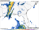
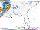
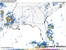
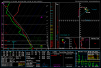
My assessment of tomorrow's scenario. The 12z NAM has one solid squall line. If that's the case, it would perhaps limit the supercell/strong tornado threat. The 12z 3km NAM has multiple lines of storms. Looks like multi-mode situation with supercells out ahead, pre frontal line of storms (those would probably be supercells as well), and then your main squall line along with the front. It's interesting to note that both the 3km NAM and HRRR signal an earlier start than the NAM. However, I get the feeling the majority of the threat will be after Sunset for most of Eastern MS into AL. My idea is that the Enhanced Risk gets expanded further north at least to Tupelo, MS and probably further east to just on Birmingham's doorstep along with expansion of the 10% SIG hatch. In the case that SPC goes Level 4 Moderate (which I can see happening), it would be part of Eastern Louisiana, portions of Central MS, and at least a small part of Western AL. One thing to note is forecast models don't handle CAPE well in advance so I would expect there to be more CAPE than currently forecasted by modeling.
Pictured are the:
12z NAM at midnight Sunday
12z 3km NAM at 1pm Saturday
12z HRRR at 10am Saturday
12z NAM sounding from NW Monroe County
Pictured are the:
12z NAM at midnight Sunday
12z 3km NAM at 1pm Saturday
12z HRRR at 10am Saturday
12z NAM sounding from NW Monroe County
Attachments
AJS
Member
Just a curious question, do you happen to know where to find these forecast models? Is there a special designated website to find them? Or are they easily accessible.My assessment of tomorrow's scenario. The 12z NAM has one solid squall line. If that's the case, it would perhaps limit the supercell/strong tornado threat. The 12z 3km NAM has multiple lines of storms. Looks like multi-mode situation with supercells out ahead, pre frontal line of storms (those would probably be supercells as well), and then your main squall line along with the front. It's interesting to note that both the 3km NAM and HRRR signal an earlier start than the NAM. However, I get the feeling the majority of the threat will be after Sunset for most of Eastern MS into AL. My idea is that the Enhanced Risk gets expanded further north at least to Tupelo, MS and probably further east to just on Birmingham's doorstep along with expansion of the 10% SIG hatch. In the case that SPC goes Level 4 Moderate (which I can see happening), it would be part of Eastern Louisiana, portions of Central MS, and at least a small part of Western AL. One thing to note is forecast models don't handle CAPE well in advance so I would expect there to be more CAPE than currently forecasted by modeling.
Pictured are the:
12z NAM at midnight Sunday
12z 3km NAM at 1pm Saturday
12z HRRR at 10am Saturday
12z NAM sounding from NW Monroe County
Just a curious question, do you happen to know where to find these forecast models? Is there a special designated website to find them? Or are they easily accessible.

Pivotal Weather
Freely available fast quality numerical weather prediction model images from the Euro, GFS, HRRR, NAM, 3km NAM and more. Pivotal Weather is changing the way you use weather data.
 home.pivotalweather.com


SHiELD
SHiELD is a system for high-resolution modeling for Earth-to-local domains.
shield.gfdl.noaa.gov
CIPS Model Guidance
AJS
Member
You are a legend sir. Much appreciatedPivotal Weather
Freely available fast quality numerical weather prediction model images from the Euro, GFS, HRRR, NAM, 3km NAM and more. Pivotal Weather is changing the way you use weather data.SHiELD
SHiELD is a system for high-resolution modeling for Earth-to-local domains.shield.gfdl.noaa.govI use all of these.CIPS Model Guidance
www.eas.slu.edu
You're welcomeYou are a legend sir. Much appreciated
Agree with @JPWX; the NAM 3km and HRRR show a quasi-linear mode, the 3km the more linear of the two. 3km can have a tendency to under-convect, evident in the UH swaths (3km at left, HRRR at right). In both cases, multiple waves of quasi-linear, and potentially discrete activity seems possible. The WRFs, which tend to be less aggressive in many cases, are quite concerning for parts of MS, much of AL and the NWern half of GA.


NorthGaWeather
Member
People in the South just don't think about tornadoes being a year round threat for some reason. I would argue, for North/Central Georgia, the main synoptic tornado season runs Nov-May, with June/July being MCS/QLCS tornado season and Aug-Oct being tropical tornado season. Wildly different levels of impact and likelihood but a year round threat regardless.I've learned, especially listening to Spann, that our tornado season down here is basically October thru the end of May.
Lengthy discussion from FFC about Saturday night/Sunday threat. As discussed before, the big question for the ATL metro is what happens to the CAD wedge. Some of the modelling, such as the HRRR shows that wedge holding during at least part of the threat duration, reducing the risk we would see. NAM 3km is a little more aggressive, and erodes that wedge somewhat as the main line comes in. Like I said, it's a toss-up until we get there, and I would still prepare for the risk of damaging winds and tornadoes in the ATL area.

.LONG TERM...
(Saturday night through Thursday)
Issued at 335 AM EST Fri Dec 27 2024
Forecast for Saturday night into Sunday remains challenging. Overall
synoptic setup remains the same with little change from previous
forecast. Anticyclonic wave break along the equatorward flank of
the upper level jet off the west coast will aid in creation of a
strong PV gradient as it pushes a piece of the Arctic tropopause
into the Great Plains, allowing for lee cyclogenesis and eventual
interaction with baroclinic zone (front) left in place by previous
systems. Translation - shortwave digs into the Great Plains and
forms a surface low that will lift to the northeast and bring
additional rain and thunderstorm chances to Georgia Saturday night
and Sunday as the system moves through.
The hi res models are just coming to the edge of when impacts would
be reaching the CWA from the main system, and they paint a few
different potential pictures that is pretty representative of the
probability space for Saturday night into Sunday morning. High
pressure off the Northeast coast will put a pretty potent CAD in
place across northern GA by Saturday night. However, high pressures
position off the coast will be less than ideal for maintaining that
CAD, instead likely aiding in WAA ahead of the approaching surface
low. In one scenario, the CAD completely breaks down. This allows
the warm sector to spread into all of north Georgia, bringing
surface based instability that will likely allow for some severe
weather chances across all of north and central Georgia. In another,
the CAD holds, keeping north Georgia free of surface based
instability and making severe weather a bit more difficult to
achieve. However, this may enhance the threat down in central
Georgia a bit, as the remaining baroclinic zone (the edge of the
wedge - say that 5 times fast) provides enhanced vorticity
generation for storm structures. Which is possible? Prepare for
both, but this forecaster will lean towards the wedge holding in
place overnight. Overrunning of warm air with ongoing precipitation
processes is known to be a mechanism by which CAD can self reinforce
without the need for ongoing CAA within the wedge itself (i.e.,
break down of the barrier jet).
As for overall severe impacts, as stated above, central Georgia
seems to be the best current overlap of the parameter space, with
potential for low CAPE high shear type setup. WAA as a surface mass
response to deepening low maintains a well mixed surface boundary
layer overnight, which should allow for surface based air parcels.
Dewpoints reach into the 60s and surface temps may even increase
in some places overnight as the storm system approaches. Shear
values depend a bit on the model and the strength of the LLJ.
40-50 kts seems to be in the range of most hi res guidance, which
allows for copious speed shear that would be sufficient for severe
weather. SRH values vary as well, but 100-200 m2/s2, and some
models showing even higher, is more than sufficient for some loose
organization. If the CAD/wedge is still in place, local
enhancement of streamwise vorticity generation along the edge of
it would provide a potential boost to any storm that interacts
with it, as mentioned above. While best forcing aloft is lifting
away from the CWA to the north by early Sunday morning, cold pool
forcing may allow for continued storm formation. Primary threats
would be damaging wind gusts and the possibility of a few brief
tornadoes. As the system progresses east during the day on Sunday,
diurnal heating and WAA should allow for destabilization of the
warm sector, likely increasing the threat a bit into portions of
eastern Georgia. The northward extent of all of this above will be
dependent on the wedge/CAD and whether or not is has broken down,
begins to break down, or continues to hold in place. If that CAD
breaks down, this parameter space will likely be in place in
northern Georgia as well.
After Sunday, air mass that moves in behind this system does not
have origins in the Arctic, so temps remain well above average.
Highs are forecast to be 10-15 degrees above average in many places
Monday and Tuesday. A quick hitting clipper type system sweeps by
the area Monday night into Tuesday. Some light rain may be possible.
This will bring a cold front through that will bring more seasonable
air as well as some gusty winds for New Year`s Eve and New Year`s
Day. This will also be a symptom of a larger pattern change that
looks to be shaping up, that will again allow colder air to pour
into the CWA by the end of next week.
Lusk