Meanwhile from CPC for Christmas Week:
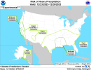
"Farther east, however, the mid-level trough will begin to tap Gulf moisture, spreading it northward across the south-central and southeastern CONUS during the first half of the period. Models have been trending wetter with this system, expanding the precipitation shield farther north and east. As a result, a slight risk for heavy precipitation covers a large area from the southern half of the Great Plains eastward across the Middle and Lower Mississippi Valley, Lower Ohio Valley, and southeastern CONUS for December 23-26. The ECMWF and GEFS Probabilistic Extremes Tools (PETs) both indicate at least a 20% probability of 3-day precipitation totals exceeding the 85th percentile and at least one inch in most of this area before the surface low pressure and associated frontal boundary shift east of the CONUS. The ECMWF PET tool is more robust with precipitation early in the period across the south-central Plains, but all of the PETs look similar farther to the east and northeast. The consensus of the tools indicate that the most likely area to receive heavy precipitation is in and around the Lower Mississippi Valley, with the PETs showing odds exceeding 20 percent of 3-day precipitation totals over 1.5 inches, which is more than depicted yesterday. Based on these tools and model trends, a moderate risk for heavy precipitation is posted for the area in and around the Lower Mississippi Valley for December 23-25. In addition to heavy precipitation, the dynamic mid-level system is also expected to increase the risk of severe weather in this same region."


.png")
.png")
.png")