• Welcome to TalkWeather!
    We see you lurking around TalkWeather! Take the extra step and join us today to view attachments, see less ads and maybe even join the discussion.
    CLICK TO JOIN TALKWEATHER

Severe Weather 2023

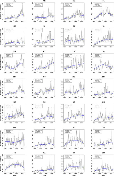
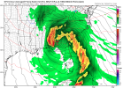
Today's 4-8 outlook forcing on the typical areas (MS LA,,AL)
SPC:
On Saturday and Sunday, the latest model runs now have a different and much faster solution. The system is forecast to move quickly across the Southeast over the weekend. Thunderstorms will be likely ahead of the trough, and a severe threat will be possible. However, due to a lack of run-to-run consistency, uncertainty appears considerable in the Southeast over the weekend.
 
GIF by Fight of The Living Dead
It may be that way awhile if the nao forecast are correct in the extended…
 
I wonder. Does anyone have a dataset or know where to find one of severe weather events based on +/- NAO across the Deep South? I would be interested in looking into that. I just thought of this in relation to @tennessee storm chaser post above.
 
"The study by Elsner et al.19 reported an association between the NAO and tornado activity in the southeast U.S. The findings of this study showed that a positive phase of the NAO (lower than normal pressures over Greenland and higher than normal pressures over the Atlantic) is linked to a lower chance of tornadoes developing across southeastern states, Arkansas, Missouri, and Kentucky." Here's the link to the article from where the above statement is from.
 
And another article on the tornado and NAO relationship.
 
I have been getting questions about x.com and twitter.com and links between the app and the webpage. I am going to do a little test here.

https://x.com/stormwx_/status/1731645866589450634?s=20

There is the possibility of Severe weather in the ArkLaTex region for day 6.
 
FYI:

 
FYI:

Thank you. This was so annoying lol
 
If you go by what SPC said in their Day 4-8 Discussion this morning, then yes.
Next weekend, deterministic 00Z ECMWF, GFS, and CMC suggest
potential for eastern Gulf or South Atlantic Coast cyclogenesis.
This may occur in response to an upper low, that initially develops
over the Southwest mid-week, being kicked east and subsequently
amplifying towards the Deep South. Very large spread in timing and
track, in addition to only a minority of ECMWF ensemble/GEFS members
supporting such a scenario renders low confidence in predictability
for the D8-10 time frame.
 
The models are giving us signs to watch the last week of December, first week of January. Also, there’s threat potential for Florida this weekend.
For those wondering too and for tropical interests, the Western Pacific has been unusually inactive (especially considering we have El Nino ongoing) and that looks to remain the case for the foreseeable future. The last time that the month of December went without a named Western Pacific tropical storm are the years of 1957, 1968, 2013, 2007, 2003, 1999, 1992, 1978, 1973, 1971, and 1970

Also, the last named storm was in October in the basin. The only other year where this has happened was 2010. For severe weather interests, the last time we had a end of December/early January severe weather threat was New Year's Eve 2010.
 
Man could y'all imagine if we had this occur during a big cold outbreak. wxtwitter would lose their minds
 

Attachments

  • gfs_mslp_pcpn_frzn_seus_15.png
    gfs_mslp_pcpn_frzn_seus_15.png
    196.5 KB · Views: 0
This though might be a precursor to what we see during the winter.
 
Every winter weather fan would simply ascend to heaven on the spot.
Yeah and Spann would have to use his suspenders to measure the snow. LOL!
 
Marginal risk out for the Florida peninsula if a slight is outlined and I'm confident a higher than average spin up risk is going to happen I'll probably make a thread. I'll keep my eye on it though. Screenshot_2023-12-14-07-29-33-91_40deb401b9ffe8e1df2f1cc5ba480b12.jpg
 
Back
Top