Mr. Clark
Member
Brad Travis says 1-3 inches...
Follow along with the video below to see how to install our site as a web app on your home screen.
Note: This feature may not be available in some browsers.

Me too unfortunately. The system would have to dig and pivot(stall) a bit too much from how the ground truth looks now. Hope I’m wrong though!Y'all I hate to be "that guy", but this really looks like another one of those situations where the cold air needed to support accumulation arrives after the moisture ends. I think we'll see some flakes, but I'm not expecting more than a dusting for most. Would love to be pleasantly surprised, but not seeing it at the moment.
View attachment 11448
if it produces to that extent, I hope I get kudos for this thread I started jinxing it in the right direction for once.So now we might end up with 6" tomorrow? I want to speak to the manager.
Oh, I live in Virginia, so idk how it's looking for y'all. This was our forecast. I really need the DC Snow Hole to come through in the clutch again.if it produces to that extent, I hope I get kudos for this thread I started jinxing it in the right direction for once.
Can`t rule out thundersnow.
If you get it, you need to share the love with The ‘Ham as well! GL though!I’m just going to drop this sentence from the NWS Huntsville forecast discussion here and let y’all salivate:
actually there is a little surface based cape all the way down to Bham for a short period of time...so a little thunder is possible here too.If you get it, you need to share the love with The ‘Ham as well! GL though!
Excellent! I was hoping so and someone earlier said Jerry Tracy said likewise. What are your thoughts as things stand now for N Central AL? Thanks fir your input too!actually there is a little surface based cape all the way down to Bham for a short period of time...so a little thunder is possible here too.

a band of heavy snow lasting around 3 hours somewhere near I65...Excellent! I was hoping so and someone earlier said Jerry Tracy said likewise. What are your thoughts as things stand now for N Central AL? Thanks fir your input too!
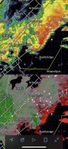
that snow band will grow and become heavier over the next several hours as the trough begins to close off and deepen. The heaviest snow band will likely be north to south from Bham area toward Cullman and then a bit wider in the Tenn Valley and will last 2-3 hours. Bham probably won'tt see much more than inch in actual accumulations, higher amounts as you go northward. It looks like the upper low will begin to pivot (slow forward movement) right as the band nears I65.View attachment 11453
Well hello there little snow band.
Excellent! Nice summary!a band of heavy snow lasting around 3 hours somewhere near I65...
that snow band will grow and become heavier over the next several hours as the trough begins to close off and deepen. The heaviest snow band will likely be north to south from Bham area toward Cullman and then a bit wider in the Tenn Valley and will last 2-3 hours. Bham probably won'tt see much more than inch in actual accumulations, higher amounts as you go northward. It looks like the upper low will begin to pivot (slow forward movement) right as the band nears I65.