
I know models predicted the current snowstorm a long way out, wonder if the trend continues.Euro just spit out an all-timer!
View attachment 33008
Navigation
Install the app
How to install the app on iOS
Follow along with the video below to see how to install our site as a web app on your home screen.
Note: This feature may not be available in some browsers.
More options
-
Welcome to TalkWeather! We see you lurking around TalkWeather! Take the extra step and join us today to view attachments, see less ads and maybe even join the discussion. CLICK TO JOIN TALKWEATHER
You are using an out of date browser. It may not display this or other websites correctly.
You should upgrade or use an alternative browser.
You should upgrade or use an alternative browser.
Winter Weather 2025
- Thread starter Thanksgivingbrown
- Start date
After seeing how absolutely beautiful this last storm left everything looking around here, I really wouldn't mind some more snow, as long as it doesn't mess up the roads!That's incredible. I'll take it, as long as it's on the weekend.
brianc33710
Member
I don't want THAT much snow! I would lose power right before near 0 temps. @Clancy or knock out power!I know models predicted the current snowstorm a long way out, wonder if the trend continues.
aujerm
Member
For the most part the GFS runs recently want to “suppress” (if this is the right term to use), the system around the 21st while the the euro seems to want to bring it through the southeast.12z Euro has the Gulf low that produces this in the same general area as this most recent one albeit further south. Would like to see more consistency in both GFS/Euro on this plus how fast each bring in the cold air before this system. However, given the GFS and Euro did far better than the Canadian with this more recent system, this does warrant further consideration.
brianc33710
Member
The GFS went really warm around that time in a recent run. Has that changed?For the most part the GFS runs recently want to “suppress” (if this is the right term to use), the system around the 21st while the the euro seems to want to bring it through the southeast.
Ledian
Member
Wow...Euro just spit out an all-timer!

Gfs usually goes northwest...prob to I20 haha
Very interesting discussions today from both MEG and JAN
JAN:
The main thing to focus on will be the potential for a strong
surface high coming out of the Canadian Rockies in the wake of the
lead system, while at the same time, a low pressure system,
supported by the right entrance region of the upper jet, pushes in
from southeast Texas. As this surface high propagates towards the
Gulf Coast region, it will bring along very cold air. Basically, 2
scenarios can play out with this:
*Pattern is more phased and surface high brings big cold, but
air is too dry to support precip and suppresses the low pressure
system to the south and we have dangerous cold to contend with.
*Pattern is less phased and the low pressure system over
southeast Texas runs into the cold airmass from the surface high and
we have wintry precip to contend with.
Neither is an ideal scenario and is a little beyond the official
forecast period, so we will have to monitor this closely as much
is still uncertain. Guidance shows this playing out sometime
around early next week, with slight differences in timing of the
features at this time. Additionally, tight pressure gradients from
the surface high will also increase concern for gradient winds,
combined with cold temperatures, we may also need to watch wind
chills towards the back end of the forecast period and
beyond
MEG:
A significant shot of polar air will move into the region early
next week as a highly anomalous trough sets up over much of the
central CONUS. 500mb anomalies are clocking in at least 2 sigma
below on both the GEFS and the ENS. A 3D animation of the GFS
Stratospheric Polar Vortex shows a sizable chunk of polar air
breaking off the main vortex early next week and parking over
North America through at least the middle of next week. As such,
the Weather Prediction Center has highlighted much of the south
and eastern CONUS for below normal temperatures the week of
January 20 to 24. Additionally, the LREF guidance is hinting at
a possibility of wintry weather during that same timeframe. Still
too early to clearly identify any wintry weather potential,
however, confidence in bitterly cold conditions is increasing for
the aforementioned week. Definitely something to watch.
brianc33710
Member
BMX: "Beyond the long term period model guidance becomes widely spread as to the evolution of this system past Saturday, which will be included & refined as that time draws closer." That was the 357 am Sun long-term talk in the forecast discussion. Nothing else was written in the 155 update.
I give it to about Wednesday and we will have a good idea if this is legit or not. Hoping it times up correctly to be on the weekend. Because I don't like playing catch-up on missed days at work haha. @brianc33710
I'm hoping we have cold air in place beforehand so it won't be as hard to forecast precip types. Besides, I don't have that much hair anymore to pull out since I got 10 inches cut off before Christmas.
brianc33710
Member
Any updates on this?
MattW
Member
- Messages
- 388
- Reaction score
- 382
- Location
- Decatur, GA
- HAM Callsign
- KG4GUF
- Special Affiliations
- SKYWARN® Volunteer
Today's Euro runs say no snow, but still decently cold. GFS is hinting at low-end snow.
We're in that back and forth period between voodoo land and reliability land lol. 5 days out should be a much clearer picture.Today's Euro runs say no snow, but still decently cold. GFS is hinting at low-end snow.
MattW
Member
- Messages
- 388
- Reaction score
- 382
- Location
- Decatur, GA
- HAM Callsign
- KG4GUF
- Special Affiliations
- SKYWARN® Volunteer
Very true, but the models were more consistent with this past snow event even at this range.
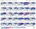
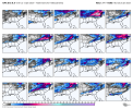
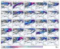
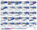
Is there any ensemble support for snow during this timeframe?
Operational models have backed off somewhat on a significant and/or major winter event. However, they haven't backed off on a major shot of cold air after the 20th.
The latest ensemble is more generous than the operational models. First Euro Ensemble is Members 1-25 and 2nd one is Members 25-50. Euro Ensemble has 50 members. GFS has 30 members and Canadian has 20 members.Is there any ensemble support for snow during this timeframe?
Attachments
-
 gfs-ensemble-all-avg-se-snow_total_multimember_panel-7849600.png163.3 KB · Views: 0
 -
 cmc-ensemble-all-avg-se-snow_total_multimember_panel-7828000.png134.5 KB · Views: 0
 -
 ecmwf-ensemble-avg-se-snow_total_multimember_panel_ecmwf_a-7828000.png172.6 KB · Views: 0
 -
 ecmwf-ensemble-avg-se-snow_total_multimember_panel_ecmwf_b-7828000.png171.5 KB · Views: 0
- Thread starter
- #99
Thanksgivingbrown
Member
6z GFS spit this out 
The only way I could see that kind of snowfall happening is if the upper trough is positively tilted and slowly pivots while more vort maxes.are feeding into it....nearly impossible and extremely rare upper air pattern.6z GFS spit this out View attachment 33018