
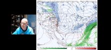
Yep. There's even some hints of it on the 12z Canadian.OK, James Spann shows the GFS with another very cold blast with snow coming in 10 days & the EURO in 11. The EURO 1st brings rain but turns it to snow. @JPWX
Navigation
Install the app
How to install the app on iOS
Follow along with the video below to see how to install our site as a web app on your home screen.
Note: This feature may not be available in some browsers.
More options
-
Welcome to TalkWeather! We see you lurking around TalkWeather! Take the extra step and join us today to view attachments, see less ads and maybe even join the discussion. CLICK TO JOIN TALKWEATHER
You are using an out of date browser. It may not display this or other websites correctly.
You should upgrade or use an alternative browser.
You should upgrade or use an alternative browser.
Winter Weather 2025
- Thread starter Thanksgivingbrown
- Start date
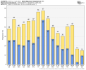
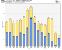
18z GFS doesn't show anything wintry around 20th, but it does have that look for something. Meanwhile, look at what the 12z Canadian and Euro both have for temps/wind chill values around and just after the 20th. I've attached the Monroe County, MS meteograms off the 12z Canadian/Euro.
Attachments
-
 gem-all-alms-apparent_temperature_f-7374400.png153.2 KB · Views: 0
 -
 gem-all-KM40-daily_tmin_tmax-6510400.png22.5 KB · Views: 0
 -
 ecmwf-deterministic-alms-t2m_f-7633600.png145 KB · Views: 0
 -
 ecmwf-deterministic-alms-apparent_temperature_f-7633600.png158.6 KB · Views: 0
 -
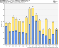 ecmwf-deterministic-KM40-daily_tmin_tmax-6510400.png25.8 KB · Views: 0
 -
 gem-all-alms-t2m_f-7374400.png147.1 KB · Views: 0
I can't recall the last time I've dealt with a post Christmas severe threat that was followed closely by another January severe outbreak plus storm damage, then snow flurries/icicles the day after, then a significant winter storm event 4 days later. To say I'm exhausted is an understatement.
Ledian
Member
Next Saturday, the high here is 56 with a 75% chance of storms...my goodness, this next temperature swing will likely be more wild than the last
brianc33710
Member
Hopefully we get a good snow with this 1 not washed away by rain. I have windmill Palms. I was prepared to wrap them with bubble wrap thinking we were getting 5 deg weather with this last bout. I may still have to do it this winter.
12z Canadian would be total disaster around the 21st (ice storm city) if that verifies. Now, the biggest obstacle as well as biggest forecast challenge with any late month winter threat is going to be timing of cold air. Unlike with this most recent event where you already had the cold air in place, this could be the opposite of that where the cold air is chasing the system. So timing is going to be even more critical unless the cold air plunges in before another gulf low forms, etc.
brianc33710
Member
This mornings run has the bluk of the cold going toward the S plains with the SE getting more of a slightly modified air mass 2-3 days later. But that could change again. Central & S. FL basically make it thru unscathed. I miss Tampa Bay :-(.
brianc33710
Member
Tomcats Forever!
Member
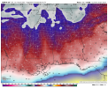
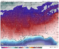
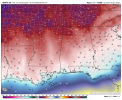
Just a bit chillyWell the map Spann shared tonight definitely doesn't spare us. Here's the Euro from Sun 25 Jan.
If the 12z Euro verifies for around the 25th, Tupelo will see their coldest January high/low temperature since 1985 and Aberdeen will see their coldest January high/low temperatures since 1962. Those wind chills values are extreme and I can't remember the last time I've seen such low wind chill values outside of a winter storm all the way down to the Gulf Coast. If anyone knows of a good website that has archived wind chill values, I would love to know!
Attachments
brianc33710
Member
Did yall have temps like this in Dec 89 & Feb 96? Huntsville & Muscle Shoals were <0 Dec 89 last time & Bham hit 1. Had we not been so windy we would've been <0 too. Last time Bham was <5 was Feb 96 when we hit 4. Both of these spells featured multiple days in the 10s too. Bham hasn't been <0 since Jan 85. Maybe wind chills were similar in Jan 2010/1/4 along the Gulf Coast? I know temps dropped very low in Jan '14 down there & in Jan '10 Dauphin Island water temp dropped to 39.If the 12z Euro verifies for around the 25th, Tupelo will see their coldest January high/low temperature since 1985 and Aberdeen will see their coldest January high/low temperatures since 1962. Those wind chills values are extreme and I can't remember the last time I've seen such low wind chill values outside of a winter storm all the way down to the Gulf Coast. If anyone knows of a good website that has archived wind chill values, I would love to know!
Last edited:
- Moderator
- #73
Did yall have temps like this in Dec 89 & Feb 96? Huntsville & Muscle Shoals were <0 Dec 89 last time & Bham hit 1. Had we not been so windy we would've been <0 too. Last time Bham was <5 was Feb 96 when we hit 4. Both of these spells featured multiple days in the 10s too. Bham hasn't been <0 since Jan 85. Maybe wind chills were similar in Jan 2010/1/4 along the Gulf Coast? I know temps dropped very low in Jan '14 down there & in Jan '10 Dauphin Island water temp dropped to 39.
I was a teenager in December '89 and remember it was record-breaking cold for days. It was horrible.
kcyalater
Member
having lived in birmingham all my life, it’s really hard for me to believe we could stay this seasonal + colder for so long. it’s beaten into my soul that we’re just as likely to see 92* and balmy on the 25th/26thIf the 12z Euro verifies for around the 25th, Tupelo will see their coldest January high/low temperature since 1985 and Aberdeen will see their coldest January high/low temperatures since 1962. Those wind chills values are extreme and I can't remember the last time I've seen such low wind chill values outside of a winter storm all the way down to the Gulf Coast. If anyone knows of a good website that has archived wind chill values, I would love to know!
i would love to see the cold stick for a bit. just no ick.
I was just focusing on January and trying to match up both the high/low temps as close as I could. However, we did see similar readings to this potential upcoming cold in December 89 and Feb 96. If I had the archive data for Wind Chill values, I would definitely be interested to know and confirm that. North MS has never had a Wind Chill Warning/Watch issued per IEM. Plenty of Wind Chill Advisories though. 12z Euro yesterday would certainly qualify for warning criteria.Did yall have temps like this in Dec 89 & Feb 96? Huntsville & Muscle Shoals were <0 Dec 89 last time & Bham hit 1. Had we not been so windy we would've been <0 too. Last time Bham was <5 was Feb 96 when we hit 4. Both of these spells featured multiple days in the 10s too. Bham hasn't been <0 since Jan 85. Maybe wind chills were similar in Jan 2010/1/4 along the Gulf Coast? I know temps dropped very low in Jan '14 down there & in Jan '10 Dauphin Island water temp dropped to 39.
brianc33710
Member
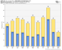
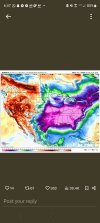
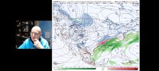
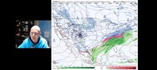
OK here are some weather maps temps for Bham. The GFS & EURO couldn't be further apart for 2 wks from now. The NBM is trying to split the difference. The GFS has 60s for highs & 50s for lows when the EURO has 10s & 5 for a low.
Attachments
-
 Screenshot_20250112-095717_YouTube.jpg1.1 MB · Views: 0
 -
 Screenshot_20250112-095854_YouTube.jpg1.1 MB · Views: 0
 -
 Screenshot_20250112-095922_YouTube.jpg1.1 MB · Views: 0
 -
 Screenshot_20250112-095629_YouTube.jpg477.6 KB · Views: 0
 -
 Screenshot_20250112-095636_YouTube.jpg540.8 KB · Views: 0
 -
 Screenshot_20250112-100240_YouTube.jpg408.6 KB · Views: 0
- Thread starter
- #77
Thanksgivingbrown
Member
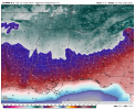
Euro just spit out an all-timer!

After digging, I finally found last subzero wind chill readings for both Tupelo and Aberdeen. Sadly, nothing I've come across has wind chill data going back to 1960. Might have to email someone higher up to get that. This also happened with no snow on the ground.
Tupelo, MS: -6 wind chill with actual temp of 7 at 7am January 17th, 2018
Aberdeen, MS: -6 wind chill with actual temp of 5 at 7am January 17th, 2018
Wind chill of 7 at Mobile with actual temp at 19 while Gulfport had wind chill of 3 with actual temp at 18. Both at 7am January 17th, 2018.
This was the day too that a patch of frost formed on the inside of my front door.
Last edited:
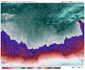
12z Euro has the Gulf low that produces this in the same general area as this most recent one albeit further south. Would like to see more consistency in both GFS/Euro on this plus how fast each bring in the cold air before this system. However, given the GFS and Euro did far better than the Canadian with this more recent system, this does warrant further consideration.Euro just spit out an all-timer!
View attachment 33008
That's incredible. I'll take it, as long as it's on the weekend.Euro just spit out an all-timer!
View attachment 33008