- Thread starter
- #21
Thanksgivingbrown
Member
Brad Travis is aboard the snow train 
Follow along with the video below to see how to install our site as a web app on your home screen.
Note: This feature may not be available in some browsers.

yeah the snow pack north of us is going harbor some very cold air not far awayfreezing rain could become a major issue for i20 corridor in alabama.

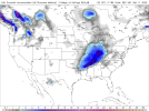
speak for yourself, there's a 10.2 right on top of meLatest GFS run snow totals. Looking good
SW AR would be such a mess with that. W SC too, and realistically any place in between in N MS, AL, and GA.Dang the ice in north Alabama on the 12z gfs


Just give me a once in a decade snow of half a foot here in Birmingham on Friday night and I'll be as happy as a little kid on Christmas haha. No ice or sleetYep, as Richard said, the 12ZGFS run is an icy mess for Cullman and south. What? A system in Alabama where the rain/frz/snow line is somewhere between Bham and Huntsville? No.... that never happens. <snicker>
There's no confidence to be had in where that line will exactly set up yet, and there won't be for days. But the trend towards a gulf low and with snow cover just to the north, there's little doubt that "something impactful this way comes".
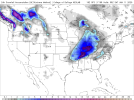
View attachment 32542
This is a better setup than I've seen in while, but these are always a goldilocks scenario - gulf low, enough cold, warm nose not too far north, etc, etc. Entirely too many variables to nail down more than a day or two in advance, and as "snowmageddon" taught us, sometimes not even then. Loving the possibility though - any time a warm gulf and and arctic blast are involved together, there's a chance that is too tantalizing to ignore.Just give me a once in a decade snow of half a foot here in Birmingham on Friday night and I'll be as happy as a little kid on Christmas haha. No ice or sleet
What has me worried is that the cold air is a bit too dense for models to handle and models maybe coming in a little warmer than it actually will be. I kinda hope that happens cause I want some snow hahaThis is a better setup than I've seen in while, but these are always a goldilocks scenario - gulf low, enough cold, warm nose not too far north, etc, etc. Entirely too many variables to nail down more than a day or two in advance, and as "snowmageddon" taught us, sometimes not even then. Loving the possibility though - any time a warm gulf and and arctic blast are involved together, there's a chance that is too tantalizing to ignore.
Yeah, I expect the model runs after this system today will look a bit different - reality being ingested after a system tends to do that. If Louisville is any indication, seems to be overperforming.What has me worried is that the cold air is a bit too dense for models to handle and models maybe coming in a little warmer than it actually will be. I kinda hope that happens cause I want some snow haha