Rapideswx
Member
@brianc33710 Yeah 14 is quite cold for here, though we got down to 12 following sleet event January of last year. It got down to 11 following the winter storm of 2021.
Follow along with the video below to see how to install our site as a web app on your home screen.
Note: This feature may not be available in some browsers.
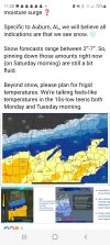
Yes this is a true observation. However, I don’t really care for the fluffy powdery snow near as much as the heavy wet snow because you can’t really do too much with the powder type. That’s the personal liking however.If temps are really cold in the I-20 area, snow ratios could/would be in the 15:1, maybe even 20:1, like 2014. So not much water would produce more snow. @cyelle21 My best friend lives in the Mobile area so I want all of us to get snow.

LONG TERM...
(Sunday night through Friday)
Issued at 324 AM EST Sat Jan 18 2025
At a glance:
- Hazardous cold to start the week -- portions of north Georgia
are likely to see dozens of hours below freezing Monday through
Wednesday
- Monitoring increasing chances for winter weather Tuesday into
Wednesday
We enter the extended range on Monday with north and central Georgia
freshly post-front, and the center of a strong (1035+ mb) Arctic
surface high nudging toward the Eastern Seaboard. With a reinforcing
shot of cool, dry air rounding the base of the broad mid-level
trough situated across southern CONUS, the stage is set for a
hazardous cold snap. The airmass that is progged to settle in across
the South originated from over Siberia, and it will certainly feel
like it. Highs on Monday and Tuesday will be in just the 20s to near
40 areawide (20-28 degrees below average) -- with highs in the teens
possible on Monday for portions of northeast Georgia at elevation.
Lows will be positively frigid, in the single digits to lower 20s
each morning through Wednesday. Lingering breezy to gusty winds in
the wake of the front Monday will support morning windchills as much
as 5-10 degrees below zero for portions of northeast Georgia, and in
the single digits to teens elsewhere. We`re looking at a slam dunk
for Cold Weather Advisory conditions pretty much everywhere, but
cannot rule out the necessity for Extreme Cold products for the far
northern part of the forecast area. Some areas along and north of
the I-20/I-85 interchange may not see real chances for temperatures
to rise above 32F until Wednesday. Proper precautions will need to
be taken to prepare for an extended period of frigid temperatures --
remember the 4 P`s of winter preparedness (people, pets, pipes,
plants) and be sure to leave your faucets dripping and under sink
cabinets open before heading to bed.
Beyond Monday, the elephant in the room is increasing confidence in
some type of wintry precipitation impacting portions of north and
central Georgia from Tuesday afternoon through Wednesday morning.
What We Know:
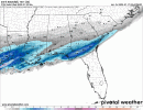
1) Unlike the previous storm system, greatest impacts are likely to
be felt further south. WPC`s Key Messages yesterday evening painted
a 40% chance of moderate winter impacts primarily along and just
slightly north of the Columbus to Macon corridor. Highest GFS and
Euro ensemble probabilities of >=1" of snow also highlight areas
south of the Metro. Some especially interesting probabilities to
note from the 01Z (most current as of the time of writing of this
AFD) NBM run:
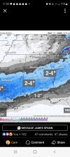
- Probability of at least 1.5" of snow in the 24 hour period
ending 7AM Wednesday for Columbus/Macon corridor: ~40-43%
- Probability of at least 2" of snow in the 24 hour period
ending 7AM Wednesday for Columbus/Macon corridor: ~30-35%
- Probability of at least 2.5" of snow in the 24 hour period
ending 7AM for Columbus/Macon corridor: ~30%
2) 24-36 hours of unseasonably cold conditions before precipitation
onset will support very cold ground/road temperatures, allowing for
impacts to ramp up quickly. It will not take much accumulation to
create hazardous travel conditions, and what accumulation does fall
is likely to linger courtesy of the cycle of diurnal melting (highs
in the 30s Wednesday, near 40 Thursday) and re-freezing (lows in the
teens Wednesday night, 20s Thursday night).
3) Our initial airmass looks to be much drier than January 10th`s.
We are currently forecasting dewpoints in the single digits to teens
areawide mid-morning/early afternoon Tuesday. This increases the
potential for wet-bulbing (evaporation of precipitation falling into
a drier airmass removes heat and introduces moisture, tugging
temperatures down and dewpoints up), which could result in
temperatures cooler than forecast.
4) The dominant p-type at this time appears to be snow for a
combination of the above reasons, with chances for freezing
rain/sleet/a wintry mix relegated to our far southern/southeastern
tier. At this time, any ice accumulations are unlikely to be as
impactful as forecast snowfall, but things can and will change over
the next several days as features become better resolved.
5) The 00Z runs of the GFS and Euro ensembles have trended wetter
than their 18Z counterparts (with the GFS serving as the theoretical
floor for this event). The Euro ensemble has also trended toward a
broader and higher snow accumulation footprint, and progs the onset
of winter precipitation to be earlier than the GFS (late
morning/early afternoon vs. mid-to-late afternoon, respectively).
The Canadian ensemble continues to be the coldest and snowiest
solution, and remains our far upper bound/ceiling for this event.
Our chances of a non-event precipitation-wise thus appear to be
lower.
What We Don`t:
1) How much wet-bulbing will occur -- could have a large impact
on who receives snow and just how much (we saw the upper bound of
wet- bulbing with the band of heavy snow that set up across the
Metro last week, and dewpoints this time around are forecast to be
even lower.
2) Exact accumulation amounts. This will depend heavily on
temperature profiles, the number of p-types, and the placement of
any surface features. Once we introduce HiRes guidance into the
mix (the next day or so) details will be able to be expounded
upon.
Given remaining uncertainty (coupled with the knowledge that
ensemble guidance overall has trended toward at least SOME snowfall
for much of the area, with higher totals the further south you go),
feel that the NBM continues to have a decent handle on the forecast.
Interests in the Atlanta Metro and points further south -- and
especially areas along and south of a line extending from Columbus
to Macon -- should keep a close eye on the forecast. If trends hold
(BIG if), this could pan out to be one of the more impactful
southern/coastal winter storms in recent memory. Stay tuned.
.png")


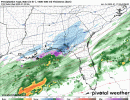
I was hoping that it would shift a tad further north myself so that the Hwy 80 corridor would be in the heavier snow area...but a lot can happen in 3 days.Because hey, the low may just go to Cuba. Expected a northerly shift of the low, went south instead.

Maybe a little.I THINK that the Euro has trended a little north.
Thank you for the comparison of the different runs...it's hard to tell sometimesMaybe a little.
")
Looked it up and appears it’s 4” officially, but unofficially may have been higher in places.Just curious, what is the snowfall record for the state of Florida? This system might put the current state record in jeopardy.
And that was on March 6th, 1954Looked it up and appears it’s 4” officially, but unofficially may have been higher in places.
So if the ratio is 15:1 in Bham, do we multiply EUROs estimates by 1.5 to get our snow totals?Maybe a little.