brianc33710
Member
That's what I've said .Hmmm. And at 10:1, I’d expect it to be a little higher on the totals given temps obviously
View attachment 33137
View attachment 33136
Follow along with the video below to see how to install our site as a web app on your home screen.
Note: This feature may not be available in some browsers.
That's what I've said .Hmmm. And at 10:1, I’d expect it to be a little higher on the totals given temps obviously
View attachment 33137
View attachment 33136
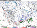
May I see the image?18z nam is a good bit south this run with precip.
*Also slower
I am still learning how to make GIFs of the model runs, so I haven't quite figured out how to do a comparison from one model run to the next.May I see the image?
Looks like the bad model trends continue as the 18z GFS is also coming in colder and farther south with the low. At least through the first part of the event.I am still learning how to make GIFs of the model runs, so I haven't quite figured out how to do a comparison from one model run to the next.

What gets me is this could totally flip on its head and go the other way real quick. I remember the last event we got down into 24 hours from the event and it changed drastically with the low pressure dissolving into like a double barrel low lol. And then also the snow line was a lot further south. I trust Blount county wolf and the more experienced guys in there take of this event instead of models at the moment. Things are being a little weird with models currently lolLooks like the bad model trends continue as the 18z GFS is also coming in colder and farther south with the low. At least through the first part of the event.
Thank you! In AL I'm feeling BMX might initially issue the WS Watch for the counties not included in the last warning. Then further northern counties could be added later. The NAM shifting south hurt.I am still learning how to make GIFs of the model runs, so I haven't quite figured out how to do a comparison from one model run to the next.
Yeah. The Canadian model might be the best option to go with this round until we get consistency (if any)All hail Canada at this point….its been so consistent!
do we know how much stock the National Weather service is putting into the Canadian model? I know this thing has been consistent the last several days were up and down.Yeah. The Canadian model might be the best option to go with this round until we get consistency (if any)


This was recently updated...they added the "significant" category to the map. View attachment 33149

")


Hey what does this mean ?Looking for guidance in a higher resolution model on the strength of the coming high pressure and HRRR throws out 1041 for Memphis... View attachment 33154
Brr.
A stronger high pressure means a) more intense cold and b) could push the low pressure further south, diminishing precipitation chances.Hey what does this mean ?
What wx_guy said.Hey what does this mean ?
That's 17 degrees at 10am in the South cold.