Chris3024
Member
Yeah, they are.I've been seeing where a lot of the local village idiots are trying it though.
Follow along with the video below to see how to install our site as a web app on your home screen.
Note: This feature may not be available in some browsers.
Yeah, they are.I've been seeing where a lot of the local village idiots are trying it though.

221
FXUS64 KHUN 101949
AFDHUN
Area Forecast Discussion
National Weather Service Huntsville AL
149 PM CST Fri Jan 10 2025
...New NEAR TERM, SHORT TERM...
.NEAR TERM...
(Tonight)
Issued at 149 PM CST Fri Jan 10 2025
A significant winter storm continues to create extremely hazardous
travel conditions across the Tennessee Valley this afternoon. By
late morning, precipitation changed from all snow to a wintry mix,
before switching to light rain over portions of the area from
the HSV/DCU metro southward as temperatures warmed just above the
freezing mark. Light precipitation will continue across the region
through the remainder of the day in the form of light rain,
sleet, or freezing rain (depending on surface temperatures) in
north Alabama -- and a mix of light snow/sleet in southern middle
Tennessee.
As the deeper moisture departs with the system pushing east,
precipitation will gradually taper off this evening and overnight.
A glance at model soundings indicates that temperatures will cool
enough to support some low chances for light snow (or possibly
freezing drizzle). Any additional snow/ice accumulations should be
light. However, the impacts (as they say) are already baked into
the cake from the earlier accumulations of snow/ice. The
combination of a snow/ice pack and subfreezing temperatures will
maintain/further create dangerous travel conditions, especially on
secondary roads as lingering snow/slush refreezes into black ice.
We will maintain the Winter Storm Warning until 12z Saturday for
now -- though this may be able to be trimmed back later this
evening once wintry precipitation finally ends. In this event,
we`d like need to replace it with an Advisory to highlight the
travel dangers from icy roads and any other lingering impacts.
&&
.SHORT TERM...
(Saturday through Monday)
Issued at 149 PM CST Fri Jan 10 2025
A stout inversion will be present overnight, keeping the dense
overcast stratus decks in place. These clouds will keep the cooler
temperatures in place for most of the day, and combined with a
decent snow/ice pack make it difficult for temperatures to warm
above the freezing mark. Latest hi-res guidance indicated
sufficient mixing should allow for a decent erosion of these
clouds late in the day -- and some limited sun may help to improve
road conditions in some areas. Still, would bank on dangerous
travel conditions continuing on secondary roads for most of the
day on Saturday.
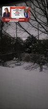
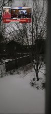
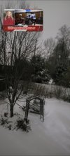
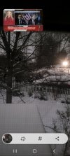

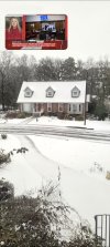
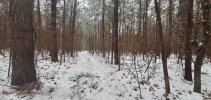
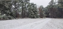
Get well soon! Pneumonia is no joke!Here are photos from my house. I'm recovering a very serious & lengthy pneumonia case, so this is the 1 time I'm not going outside to take snow pictures. The 1st 5 pics are from 545 am, which is why they're so dark.
URGENT - WINTER WEATHER MESSAGE
National Weather Service Peachtree City GA
342 PM EST Fri Jan 10 2025
GAZ001>009-011>016-019>025-027-030>039-041>060-111000-
/O.CON.KFFC.WS.W.0001.000000T0000Z-250111T1200Z/
Dade-Walker-Catoosa-Whitfield-Murray-Fannin-Gilmer-Union-Towns-
Chattooga-Gordon-Pickens-Dawson-Lumpkin-White-Floyd-Bartow-
Cherokee-Forsyth-Hall-Banks-Jackson-Madison-Polk-Paulding-Cobb-
North Fulton-Gwinnett-Barrow-Clarke-Oconee-Oglethorpe-Wilkes-
Haralson-Carroll-Douglas-South Fulton-DeKalb-Rockdale-Walton-
Newton-Morgan-Greene-Taliaferro-Heard-Coweta-Fayette-Clayton-
Spalding-Henry-Butts-Jasper-Putnam-
Including the cities of Blue Ridge, Greensboro, Washington,
Decatur, Rome, Douglasville, Monroe, LaFayette, Trenton, Comer,
Conyers, Bremen, Riverdale, Summerville, Lawrenceville,
Woodstock, Hiawassee, Commerce, Peachtree City, Homer, Cumming,
Cedartown, Madison, Monticello, Dallas, Jackson, Covington,
Carrollton, Gainesville, Franklin, Newnan, Winder, Atlanta,
Watkinsville, Griffin, Blairsville, Cleveland, Marietta, East
Point, Stockbridge, Fort Oglethorpe, Chatsworth, Calhoun, Athens,
Eatonton, Dawsonville, Ellijay, Dalton, Jasper, Cartersville,
Crawfordville, Crawford, and Dahlonega
342 PM EST Fri Jan 10 2025
...WINTER STORM WARNING REMAINS IN EFFECT UNTIL 7 AM EST SATURDAY...
* WHAT...Heavy mixed precipitation. Additional snow accumulations of
one inch or less are expected, mainly north of the Atlanta metro
area. Locally higher snow accumulations are possible across the
northern mountains. Additional ice accumulations of up four tenths
of an inch possible.
* WHERE...Portions of central, east central, north central,
northeast, northwest, and west central Georgia.
* WHEN...Until 7 AM EST Saturday.
* IMPACTS...Roads, and especially bridges and overpasses, will
continue to be slick and hazardous. Significant ice accumulation
on power lines and tree limbs may cause widespread and
long-lasting power outages. Power outages and tree damage are
likely due to the ice. Travel could be nearly impossible. The
hazardous conditions will impact the afternoon and evening
commute. Impacts will continue overnight and into the morning
hours Saturday, as slushy roads refreeze.
PRECAUTIONARY/PREPAREDNESS ACTIONS...
If you must travel, keep an extra flashlight, food, and water in
your vehicle in case of an emergency. The latest road conditions for
the state you are calling from can be obtained by calling 5 1 1.
Persons should consider delaying all travel. Motorists should use
extreme caution if travel is absolutely necessary.
&&
$$

Thank youGet well soon! Pneumonia is no joke!
") .
.