

Navigation
Install the app
How to install the app on iOS
Follow along with the video below to see how to install our site as a web app on your home screen.
Note: This feature may not be available in some browsers.
More options
-
Welcome to TalkWeather! We see you lurking around TalkWeather! Take the extra step and join us today to view attachments, see less ads and maybe even join the discussion. CLICK TO JOIN TALKWEATHER
You are using an out of date browser. It may not display this or other websites correctly.
You should upgrade or use an alternative browser.
You should upgrade or use an alternative browser.
Winter threat: 1/9-12/ 25
- Thread starter DetectiveWX
- Start date
Vertical
Member
About 10 miles north of I-20 in St. Clair. There’s not much on the ground at all. Very light snow atm.
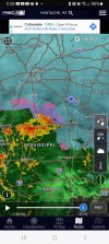
Basically - Lake Pontchartrain area/New Orleans. This is a result of the evap cooling when the heavy precip hit the dry air, IMO - cooled the whole column to height, and thus, snow.So far, the rain/junk line vs sn is well to my SW. If anything, it "appears" to be retreating more SW.
Not sure if, or how long, that will hold.
Is the low in the gulf still offshore? I'm guessing yes.

sak
Member
i think i now have a snow/frz rn/sleet mix as i’m hearing a few ice pellets hit my roof
We are seeing a change to a mix in Bham at times. Mostly snow right now and quite heavy
Smokedevil
Member
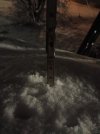
Bout 2" here now. Sning very hard.
Smokedevil
Member
The Bammer
Member
About 2 inches here and still steadily falling. Temp is down to 30. Looked and sounded like a rain/mix and 34 degrees at 3 when I got up to check. Then had this nice surprise when I got up at 5!
Suspicious boundary in S Jefferson now. Still snowing in Tuscaloosa?

Geno
Member
Changed to rain in Tuscaloosa. Still 32.
Smokedevil
Member
I was afraid of that. There's your rain/snow line on the Nexrad I shared above. SW Jefferson, I expect.Changed to rain in Tuscaloosa. Still 32.
Smokedevil
Member
I hate to say it, but that mix line is now creeping NE.
Mr. Plow
Member
All sleet here in Hoover now. Temps still around 30 per nearby Wundergound sites.
- Moderator
- #755


Nice wet snow coming down in Wedowee, AL!!
Man I feel like my work could have just delayed start times if that rain line is creeping up this quick. Albeit no guarantee where I'm at that the temp will get above freezing today.
Yep - the HRRR scenario. I am somewhat hopeful that the lesser returns back west will mean we see less "wash it away" or freezing rain though. Fingers crossed we get to keep a bit of this or at least don't get much freezing rain.I hate to say it, but that mix line is now creeping NE.
Last edited:
31.5 degrees here with a inch of snow.
Equus
Member
Couple inches of snow on everything, it's a nice serene sight before the mix comes to ruin it all lol
sak
Member
29.7, 3 inches, now pretty much all sleet/frz rn